

Kmlwx
-
Posts
13,203 -
Joined
-
Last visited
Content Type
Profiles
Blogs
Forums
American Weather
Media Demo
Store
Gallery
Posts posted by Kmlwx
-
-
3 minutes ago, Eskimo Joe said:
Per some sky cams, there is some blue sky trying to work into Garrett County. It's definitely a bit more muted than i'd like for today, but it's not going to take much instability for an active afternoon to be realized.
There's also not a whole lot of a gap between the current clouds on satellite and the clouds forming behind. Needs to hurry up and get here.
-
 1
1
-
-
The forecaster for the new D1 was Thompson and Kerr - are they known to be bearish?
-
Did the 12z IAD sounding get abducted by aliens?
-
The new SPC D1 is pretty lame lol. For the superstitious folks out there that's probably exciting news.
-
1
-
-
3 minutes ago, Eskimo Joe said:
All the low levels clouds are clearing out pretty rapidly down here. Event some if the mid level junk is trying to break up.
IT'S HAPPENING
-
 1
1
-
-
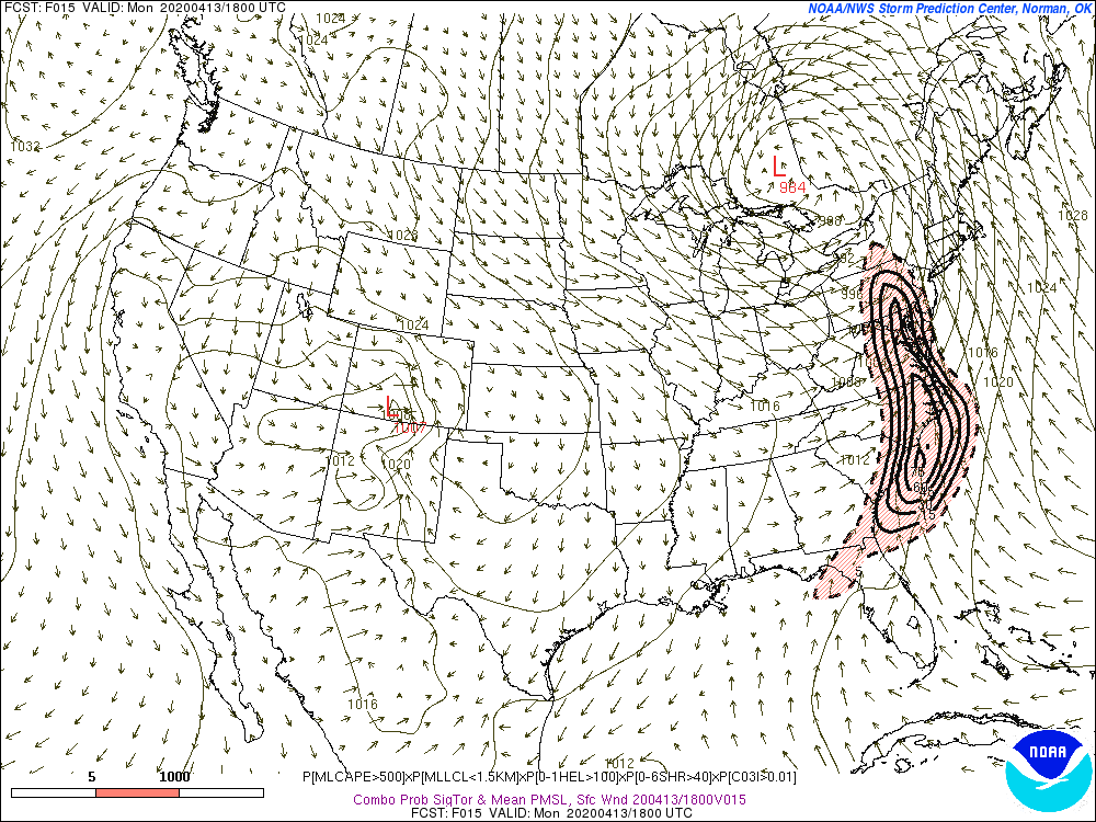
From the 03z SREF products on the SPC page -
-
1
-
-
1 minute ago, mappy said:
then whats the point of this thread and an obs thread? if we are going to post our severe winds, watches, rain, etc in that thread... why have this one?
True - and it's already day-of. I think in the past we had treated this one as more like the winter-time "Long Range Discussion" thread. Arguments for both I guess - I definitely don't mind staying here. Though for anybody reading back in future years - does make it easier to find if it's a separate event thread.
Let's stay here. -
1 minute ago, Eskimo Joe said:
The latest one.
The 06z 3km NAM is really nice around 16-17z locally too. Good UH tracks too...those are weak sauce on the HRRR for now.
-
Should we migrate to the obs thread? Or should we split into a thread specifically for this event? I realize it's kind of late into the event...but still something to consider.
@mappy - what say the mods?
-
Just now, Eskimo Joe said:
HRRR is lit for us later today. Tons of discrete stuff through 18/19z. Really hope this isn't a care of the HRRR being HRRible.
It could be - nice when it improves in closing, though. What run are you looking at?
You know the joke - the HRRR will be right 2 hours after our event! -
This batch of rain is going to be really bad for later. Even areas of my parent's yard (I'm in Colesville today) are completely water logged and spongy. There is major ponding. We are moving all of our cars out from under trees once the rain tapers off.
-
Just now, Eskimo Joe said:
For @Kmlwx et al, here is the SRM color palate that I use.
Thanks!
-
1 hour ago, Chinook said:
Not sure if anybody replied
Here's what I use
Thank you!!
-
Ready for my prefrontal wind.
-
1
-
-
10 minutes ago, Eskimo Joe said:
I could see the ENH get pushed to Mason-Dixon for wind. And have the 10% TOR go from a JYO to DCA to SBY line.
My ceiling scenario for the D1 would be 10% TOR w or w/o hatching to the Mason Dixon Line, 45% wind, 15% hail. I think that's max for us.
-
My call for the new D1 outlook will be (for DC proper) 5% TOR with the 10% very nearby. 30% wind and 15% hail.
-
-
5 minutes ago, Eskimo Joe said:
So far, things appear to be on time, if anything the system is a tad north of everything and the activity is remarkable discrete down south. Not really congealing into a QLCS.
Still time for that to happen, though. It would be great if we weren't socked in tomorrow morning when the sun came up.
-
12 minutes ago, Eskimo Joe said:
FYI, this was posted in the SE forum. Impacts potentially the timing, etc. for tomorrow:
This always happens as we close - things slow down but ultimately the storms race out faster.
-
1
-
-
2 minutes ago, osfan24 said:
Business picked up in a hurry. Pretty concerning for what we could see tomorrow.
Also a linear system back in western MS producing winds of up to 70mph according to the warning.
-
1 minute ago, Eskimo Joe said:
RAP is usually very stingy IIRC. I still think the major tornado risk is along and south of I-66 to DC to US 50 to SBY, but man it's not going to take that much for this to be a very memorable event in these parts even by my standards.
A lot of the CAMs (like the ARW, ARW2, NMM) want to throw all the eggs into the morning stuff and don't really have all that much for the 2nd round. I honestly would not be surprised if only one round really comes to fruition. Which one that is will probably determine our threat. It looks like a corridor to watch is going to be a slightly steeper angle than I-95 and running from like DC southward to the RIC area.
-
The 21z RAP is coming in with upwards of 2300 (corrected) 180mb MLCAPE
Pockets of 2600 SBCAPE...
-
2 minutes ago, Eskimo Joe said:
Let me remote into my work PC and I'll send you the SRM that I use.
EDIT: Our VPN is down for maintenance right now so I'll just share the SRM file tomorrow morning in this thread when I get in work.
You rock. No rush. It's ultimately not that urgent. I see all kinds of pretty ones on Twitter during events and I've never gotten around to loading something other than the default.
-
7 minutes ago, southmdwatcher said:
I have a transparent BR file and some other SRV/BV files.
Biggest issue I have with the velocity color tables I'm using now is they aren't bright enough. I think they are actually the defaults. If they work with level 2 data would you mind sharing? DM me? Thanks!

2020 Mid-Atlantic Severe Weather - General Thread
in Mid Atlantic
Posted
What would be really nice is if the back edge of these clouds we are under now started to erode while concurrently moving out. Not seeing that so far.