

Kmlwx
-
Posts
13,203 -
Joined
-
Last visited
Content Type
Profiles
Blogs
Forums
American Weather
Media Demo
Store
Gallery
Posts posted by Kmlwx
-
-
In practice - I feel like these lines tend to speed up even if just by a bit with time.
-
25 minutes ago, Eskimo Joe said:
IMO, tomorrow is a QLCS tornado kind of day. Wouldn't surprise me to see a D1 ENH and a red box or two go out.
Whoa...who are you?
-
 1
1
-
 1
1
-
-
3k NAM gets MLCAPE to 500+ into the area. Not bad.
-
1
-
-
28 minutes ago, Sparky said:
6/1/12 - the day of the tornadoes. It was a scary day for me with a relatively close call near my neighborhood with an EF1 tornado followed by a couple more menacing cells that day which threatened dropping one.
I think there was also a day (was it that one?) that had tornado watches for all or part of the area for like 24 straight hours or something. And I think a day in June 2013 that had a long track EF-0 tornado in MoCo.
-
21 minutes ago, George BM said:
I too remember that day. I just remember it raining heavily at times (with some lightning early in the afternoon) through about 3pm followed by skies rapidly clearing for late afternoon sunshine.
That day was certainly nothing compared to your favorite event two springs later on a June 4th afternoon. I wouldn't make it out of school to see that one though.
For as much crap as we all love to talk about DC failing at severe - we've had some pretty memorable days to track around the area - even if everyone didn't get hit. 9/24/2001, 4/28/2002, 6/4/2008, 6/29/2012 have all been truly special severe days around the DC area. There are some others as well.
-
1
-
-
7 minutes ago, George BM said:
Would be interesting to get the line through the region between 6 and 9pm.

I think even with it coming in during peak heating it'll probably have very limited instability to work with. Ultimately it'll probably turn out very similar to the other day...tough for us to get anything of significance this late.
November 16, 2006 had a 10% hatched tornado locally. It was exciting but not a whole lot happened. I remember rushing home from school. I think there was some isolated flooding. The reports from that day are very anemic on the SPC archive.
ETA link for reference: https://www.spc.noaa.gov/exper/archive/event.php?date=20061116 -
23 hours ago, high risk said:
it's definitely on the table, as the wind fields ahead of the fropa will be fantastic. As with all of our fall systems, though, it's a question of instability. Should be plenty warm and moist ahead of the front (Thursday night ?), but we may again deal with showers being too widespread to allow for any decent low level lapse rates.
The timing looks pretty poor for now. 3km NAM and GFS seem to bring any sort of line in here at bad times in the diurnal cycle. I know this time of year the cycle matters a little less than it would in summer. But that doesn't bode well for having a peak of instability. Would like to see it either speed up to arrive Thursday afternoon - or slow down and nudge into the day on Friday. Shear looks excellent as you said. Assume we'll just get a pencil thin squall with no thunder/lightning with some gusty winds. Sub-severe would be my guess.
-
2 hours ago, yoda said:
Looks like one more chance Froday force severe storm... SPC day 4-8 disco mentions the chance
We'll see how it looks when we get to the midweek timeframe. GFS has the timing pretty bad right now.
-
It's about as good as we can get for this time of year short of a massively dynamic storm. I can recall a decent severe day in mid-November back when I was in high school. Maybe 2006?
-
1
-
-
36 minutes ago, EastCoast NPZ said:
Moderate drought on the heels of a 2 inch rainstorm in the Eastern areas seems odd.
It had been in the "severe" category. 2 inches still leaves a deficit. That map is typically a slow adjustment too since hydrology can be a trickle down effect at times. If we don't revert to a super dry pattern, you'll see that improve more next week.
-
1
-
-
40 minutes ago, bigtenfan said:
The one coming off Cape Verde now looks almost certain to be a threat to shipping lanes only. The orange coming out behind it also looks like it might recurve.
Not according to the 12z GFS in fantasy land

We'll see every solution in the coming week.
-
17z HRRR is pretty much missing a bunch of the ongoing activity. We'll see if the 18z looks different.
-
Maybe an isolated shot at some severe this week.
-
Looks lame unless you're south of DC.
-
No real changes on the 1730z
-
14 minutes ago, yoda said:
SPC seems like they are going to go mod at 2000 OTLK across SE IA/IL/W IN for either wind and/or tor probs... 1630 has 10% hatched tor and 30% hatched wind... wonder if any of that will make it over to us tomorrow... 1730 SPC disco should be interesting
Would assume nothing will be changed until D1.
-
The College of Dupage site has been down for days it seems...shame.
-
The SKYWARN training was postponed to the alternate date for anyone registered.
-
 1
1
-
-
HRRR and 3km NAM both blow some storms up I-95 and east but the area between there and the BR is pretty boring. .
-
24 minutes ago, nw baltimore wx said:
Have you got a map? Thanks in advance.
-
1
-
-
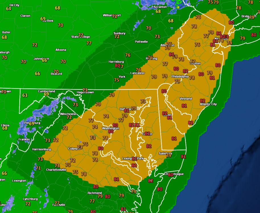
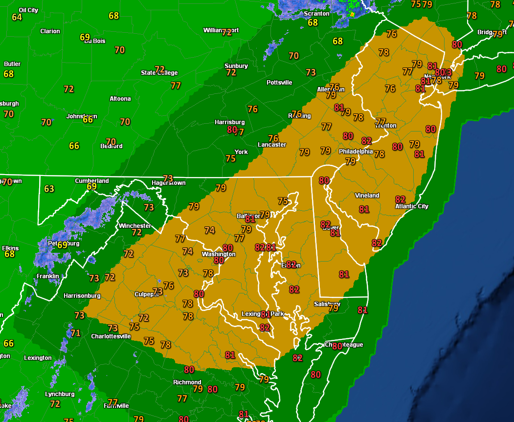
Slight risk expanded.
-
There's a fast moving outflow boundary coming NE from the storms in VA. That could ignite some additional storm development into the metro areas. Radar is looking pretty lit up to the west and southwest.
-
1
-
-
The wind gust product on the COD model page shows that line packing 50-55kt winds.
-
18z NAM nest brings a bow echo type complex on a direct hit through the metro area tomorrow PM.
-
1
-
October Discobs 2019
in Mid Atlantic
Posted
Lol...from the 12z HRRR.