ORH_wxman
-
Posts
93,110 -
Joined
-
Last visited
Content Type
Profiles
Blogs
Forums
American Weather
Media Demo
Store
Gallery
Everything posted by ORH_wxman
-
Active mid December with multiple event potential
ORH_wxman replied to Typhoon Tip's topic in New England
That stat can’t be right for snow depth. Do they mean snowfall on Christmas Day itself? (2012 and 2017?) -
Active mid December with multiple event potential
ORH_wxman replied to Typhoon Tip's topic in New England
No it definitely looks more miller A than a couple days ago. That said, it could still go more hybrid f we get some NW ticks as it would result in a stronger primary trying to go into OH valley before the coastal becomes fully dominant. We’ll just have to wait and see. Some of the NW solutions are kind of like that. -
Active mid December with multiple event potential
ORH_wxman replied to Typhoon Tip's topic in New England
Tickled SE a little on the 06z but still there. I’m not convinced yet of more than a C-2” but we watch...id love to grab a couple inches as an appetizer. Maybe we get lucky and it’s a little more. -
Active mid December with multiple event potential
ORH_wxman replied to Typhoon Tip's topic in New England
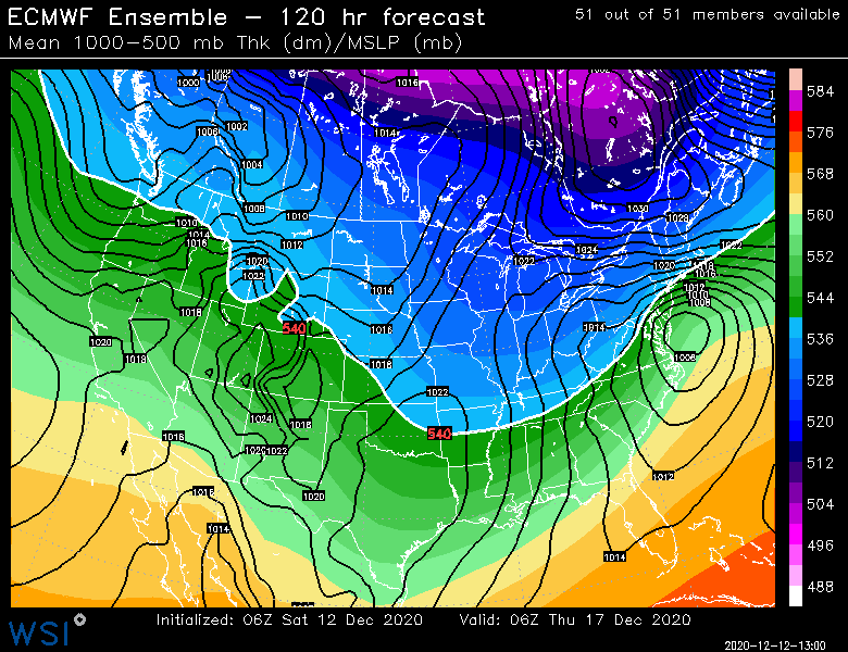
Notice how it kind of hugs the coast down south and gets warmer midlevel air into NJ but then runs into a bit of a brick wall and moves ENE. Youre probably going to get a hellacious fronto band near on the northern side of that. -
Active mid December with multiple event potential
ORH_wxman replied to Typhoon Tip's topic in New England
06z EPS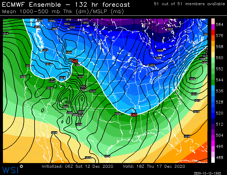
-
Active mid December with multiple event potential
ORH_wxman replied to Typhoon Tip's topic in New England
He sometimes thinks he lives in Pittsburg, NH. He’s in double digits on most guidance and near jackpot in midlevels on a couple runs. -
Active mid December with multiple event potential
ORH_wxman replied to Typhoon Tip's topic in New England
Lol 06z GFS goes insane. Juicier than 00z for most of SNE. -
Active mid December with multiple event potential
ORH_wxman replied to Typhoon Tip's topic in New England
Ukie at 120. By 144 it’s way northeast so we’d need to see 132 but this looks more NW than the more sheered 12z run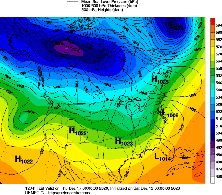
-
Active mid December with multiple event potential
ORH_wxman replied to Typhoon Tip's topic in New England
It’s def a miller A on some of these runs where the S/W digs down and then shears a bit. You never get a strong primary into the Oh valley on those runs. I’m still a bit leery though of that considering how potent the shortwave is and going neutral pretty early on. -
Active mid December with multiple event potential
ORH_wxman replied to Typhoon Tip's topic in New England
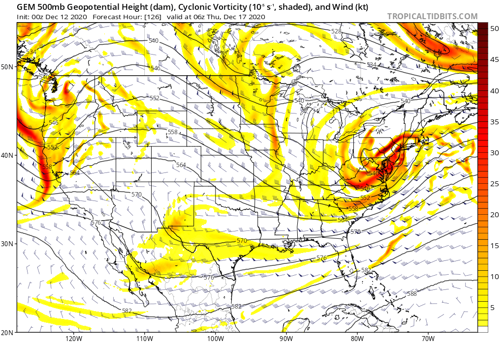
Canadian showing the H5 pretty strong here...you can see how this can get snow pretty far NW without too much more trending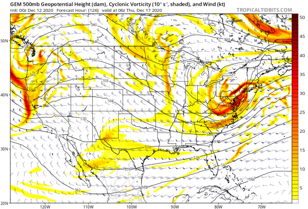
-
Active mid December with multiple event potential
ORH_wxman replied to Typhoon Tip's topic in New England
Yep. This is the solution when the shortwave gets sheared pretty strongly in the final 18-24 hours. You can imagine the storm making a pretty strong run at that high on runs where it holds together better. -
I think I’d still want to be north of philly on that setup despite the runs today getting the snow pretty far south. The shortwave is pretty amped out in the plains/Midwest so I’m envisioning this thing getting more zonked as we get closer. Though northern MD is as good as anywhere if you’re going to be south of PHL. Doesn’t always happen but there’s a pretty consistent pattern of the storms that get squashed a lot and almost all of them are much weaker shortwaves when they are still pretty far west. One of the exceptions was Feb 5-6, 2010 but that one had a MONSTER block that was way further south than this setup. So unless this shortwave ends up a lot weaker or the fundamental orientation of the block changes, I’d hedge northward bumps.
-
Active mid December with multiple event potential
ORH_wxman replied to Typhoon Tip's topic in New England
Trended southeast from 12z. I mostly expect a non-event for Monday in SNE. -
Kind of a bummer that NNE won’t get much snow out of this (CAD region of W Maine might see a little) ...I was thinking that they probably would once it started trending but then it kind of stalled and trended a slight bit back NW. At least the sfc wedge is happening so very little snowpack loss up there. 4 days ago it was a 55F cutter.
-
Yep, there's a lot of events that are not coastals that will hit our area and maybe not V NT or NH/ ME....things like clippers that track S of LI or even overrunning events that struggle to get warning snows north of central VT/NH. Also the occasional IVT that dumps a few inches. The Killington number definitely looks inflated unless maybe they were measuring near the 4k summit and perhaps it's only mildly inflated. But then it wouldn't be apples to apples comparison to other ski resorts since you shouldn't measure at the summit.
-
You might get decent snow this weekend too. One thing that will tak a while getting used to is not to fear modeled cutters as much....they often turn into what we're seeing on the Euro. It doesn't make a difference for MD, but in NE (esp NNE) it can go from 50F rainer to snowstorm in a couple cycles.
-
Megan and I stayed at the evergreen inn a couple times before we had kids when we were doing “budget” Sunday River trips. That place is hilarious. They haven’t changed anything inside since they built the place around 1970. The decor is straight out of that era. Also, when we pulled up, there was always like milk and beer in the snow outside staying cold, lol. Always tons of snow mobiles chained up to the trees out back since the trails have access right to the inn. When I chatted with the owner, he told me how it’s mostly snow mobilers but that they do get some skiers like us too that make the 25-30 min trip to SR or Mt Abram.
-
For a MA hill east of the Berkshires, it has some good vertical. Like almost 600 feet? Its kind of surprising that it couldn’t stay open given the lack of areas within an hour of Boston. I wonder how it would do if it reopened today with some decent infrastructure. I’m guessing it would be viable. We wont find out though. I think it’s like designated wilderness land or something now which would probably make it really hard to reopen a ski area.
-
There was a pretty localized event in February 2015 in Boston I recall. I think it was maybe feb 11th or 12th. There was like an IVT with a streamer coming in off Boston Harbor. I rode the train into work that day...back then my office was on the seaport pretty close to Logan. There was sun shining in back bay and Fenway area, by the time I got to south station is was snowing steadily but pretty light. Prob like 3 mile vis. By the time I got to the seaport east of south station there was these perfect LES dendrites falling with like 1 mile vis. I think we ended up with 2 or 2.5” in about 4 hours there while even just north at Logan had about 1.5 and then back west around Fenway they had just a dusting. It was so weird. I think parts just south of where I was near Hull had at least 3”+ of pure 30 to 1 blower powder.
-
Wow nice. Watatic still has a lot of very skiable trails visible on it. It's amazing how long they have lasted considering it hasn't been open in over 30 years.
-
Yeah Jefferson is still way better than places like Lancaster and Whitefield, but they are on the "same side" of the terrain as them, so that's definitely why there is a notable difference between them and Randolph which is on the other side of those key terrain features. The snowfall seems to really increase once you get into the "curve to the east" part of Rt 2 about a couple miles east of downtown Jefferson.
-
The old Jefferson coops and the NORHC snow map archives showed a clear decrease of snowfall into Jefferson vs Randolph on the other side of Pilot/Pliny range.NE wind def downslopes them and they don't have the CAD capacity that further east does.
-
Yeah your top storms in Jackson will be way better than N Conway. Some of those long duration firehose storms give almost grotesque snowfall totals there. Like I think the late February 2010 storm put up some ridiculous number in Randolph.
-
I'd feel pretty good for the white mountain gang over eastward into interior Maine....that swath has the most wiggle room.
-
Best event by far where I am was 2/5/16. I had about a foot of mashed potatoes. The snow was even wetter down in SE MA where I think they had some legit power issues from 7-8” of cement.