

ORH_wxman
-
Posts
93,098 -
Joined
-
Last visited
Content Type
Profiles
Blogs
Forums
American Weather
Media Demo
Store
Gallery
Everything posted by ORH_wxman
-
ID card requirement is gonna be tricky....hippa act stuff. That's also a bit of a despotic road you don't want to go down. Once the vaccine has been widely available for a couple months, you just lift all restrictions. If people don't want to get it, it's on them and it is not up to society to cater to them.
-
I'm sure after a certain amount of time has passed, they can mandate it for things like public schools (which already have vaccine requirements).....but yeah, in an absolute sense you can't actually force people to take a vaccine if they don't want to.
-
Once there is widespread availability of the vaccine (i.e. no waiting for anyone who wants it), there should be no restrictions. Hopefully that means by the time we get into warm season 2021.
-
It’s still pretty early. Even up there November can be quite spotty...some years it seems to really feel like deep winter and permanent snowpack sets in by 2nd or 3rd week but there’s plenty of years where it’s not much at all.
-
Yeah in Jackson, he will get less upslope than phin and def less upslope than Alex. Wrong side of the presidentials. But that area does really well on the typical WAA systems and coastals.
-
You’re gonna clean up on some of these easterly flow events/coastals and on CAD events you’ll do really well too. You’ll be like one of the last places to mix with sleet on those CAD type of systems (if you do at all). Places like Plattsburgh over to BTV might be ripping sleet pellets while you are S+. Jspins location was designed in an upslope weenie’s basement on their computer game “sim snow 2000”. That’s their bread and butter. Getting a few inches here and there when similar elevations are getting a dusting or flurries.
-
I mentioned boxing day in the part you bolded.
-
2010-2011 was weird in that the pattern actually got pretty damned good in early December, but we got skunked for like 2 weeks straight. Huge -NAO and active PJ, but we still found a way to get a massive cutter in there and then everything else got shredded in poorly-timed meat grinders. We finally got a storm to retrograde underneath the massive block in the Dec 20-21 timeframe that hammered Cape Cod (and parts of Maine?) and gave 2-4" to the rest of us in New England, and then of course the Boxing Day model bust. Then we relaxed the pattern a bit around New Years before going into the epic January 2011 stretch. The model guidance didn't really "see" an epic stretch per say. It showed a persistently favorable pattern though without any warmups. We had the big -NAO until the 1/12/11 storm and then we actually went into a bit of a +PNA pattern for a time before another weak NAO block formed and then was erased in the 1/27/11 storm. We had loaded dice and they kept coming up 7s for us is essentially what happened.
-
That's true for younger kids, but not as much for the high school aged and college aged kids. They still transmit pretty effectively. Might not be as efficient as a 45 year old, but pretty close it seems from the prelim papers. The elementary school aged kids seem to only transmit at half the rate and toddlers even less. I'll also add that the spreading seems to be done outside of school more than in it. There was that study from CT a month back or so that showed a ton of transmission is occurring in carpool settings and after-school gatherings.
-
High school kids don't wear them very much outside of school. My wife tells me she will see them all hanging around someone's car after school and they have all taken their masks off and they are terrible about staying distanced at lunch time when they are allowed to take them off inside. That's definitely one reason cases are spreading...they teenagers and younger college-aged crowd don't really wear them....they'll spread it to older people. People are also staying inside more now that the weather is colder.
-
Yep, the usual suspects would say "oh here we go again!!!11! Always 10 days away!!!11!1!" That said, this has been increasing in intensity as we inch closer the last couple days. So I think there's a good chance is materializes.
-
Every time guidance has shown a pig since early month, it hasn't materialized in any meaningful way. This one looks a bit more robust but who knows. It's still in the 11-15 day.
-
Yeah....I feel like every April recently has blocking, lol....but the correlation during the winter months with robust blocking in November/early December is pretty good. For some reason it just never happened.
-
Pig last winter didn't set it until late December. Kind of a weird year. Usually when you have good blocking early in November and December, it reloads during the winter....sometimes multiple times. Last year the early blocking just gave way to a horrendous pattern. There was a brief time it looked like high latitude blocking would come back in late January....it actually almost looked like a 2015 EPO-redux, but then it collapsed spectacularly on guidance inside of 7 days. The key on the pig is does it stick around? If we get to, say, 11/25, and it doesn't show signs of breaking down on the ensemble guidance in December, then I think I'd be very worried.
-
zzzzzzzzzzzz for a while
-
Had my first when I was 34. Have two now...older one is 4 and younger one is 1. They make me laugh a ton. It’s pretty underrated how funny young kids are. I don’t think I woulda been ready in my 20s but who knows for sure. Might have forced me to grow up a lot faster too, lol.
-
Even if there were a few issues with the house, the plot of land with that type view is worth a long term investment. Just that view alone is worth a lot. It’s almost gravy that the house is in pretty good shape. That part of NH barely north of the presidentials over to the mahoosucs in adjacent Maine is still a relative secret but it won’t be forever.
-
Western slope is tough for retention. Esp if it's steep.
-
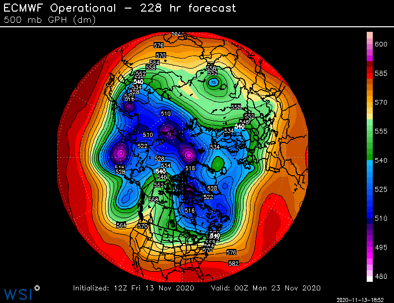
Even this run, after going a little bit zonal for a couple days, it buckles the flow again at D9.....this is just a useless OP run, but you can "see the potential" if things were to break the right way in the details
-
Isn't this essentially what places like the Hermitage Club already are? Country club setting for a ski resort. Out west, you get even bigger/more exclusive ones like Yellowstone Club. I'd hope that there are enough survivors post-covid to keep prices reasonable.
-
There's plenty of debate to be had on lockdown severity and the pros/cons of it....but this isn't the thread for discussing general lockdown policy....we all know where most everyone stands on it and it always goes around in circles. I think it's fine to discuss local covid-related issues in here (i.e. what our local schools are doing, local ski areas, etc, etc) but when we start going back to generalizations and policy theory/discussion, it inevitably just turns into a political discussion.
-
2020, the year skiing went from a middle class/upper middle class hobby to a silver spoon hobby.
-
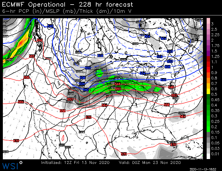
This pattern definitely looks a bit like a roller coaster....Sunday could be pretty mild, esp if we get some sunshine. 60+ not out of the question? Then we go pretty damned cold for several days following with a good possibility of flurries or snow showers around on Tuesday and Tuesday night/Wed morning could be our coldest night yet. The pattern beyond that though looks interesting...it's showing up as pretty blocky but also a tendency for western troughing, so those will be opposing forces for our corner of the CONUS. Yeah at least they looked good....they aren't worth much that far out, but that was a flip from earlier runs. I'm starting to be intrigued by the blockier look on a lot of runs for the D8-12 range. That is a good sign because it wasn't that long ago that those days looked kind of ugly on guidance. So I'm hoping that it means there is a tendency to not allow an AK vortex to set up shop for any amount of time. Also, historically, it is good to have blocking in November. I know it doesn't work all the time (see last 2 years), but you'd rather have it than a death vortex for sure.
-
I'm hoping this will cause more people to go to some of the smaller mountains. Some of those places are nearly empty during week days, but perhaps they can pick up some extra business because larger resorts are capped. Hopefully that helps offset at least some of the losses they are going to have on the weekend.
-
I think many could see flakes on Tuesday....as the trough axis moves underneath us. Not a big deal but some snow showers around. Prob some minor accumulations in the usual mountain spots (Berks up to Greens and Whites)


