

ORH_wxman
-
Posts
93,099 -
Joined
-
Last visited
Content Type
Profiles
Blogs
Forums
American Weather
Media Demo
Store
Gallery
Everything posted by ORH_wxman
-
Yeah, it's just the timing of the epic grinch distorts the "feeling" of it. But I personally enjoyed Xmas eve a ton...it had the reggae weekend vibe at the ski resorts....we were burning the firepit outside with temps near 50F and deep snow cover. My son making and then destroying a snowman, lol. Xmas day itself though was a total bummer. No denying that. 2017 this was not.
-
This was admittedly worse than most grinches. There was deep snow cover across a huge percentage of the posting subforum after a pretty big time storm on 12/16-17....those types of storms don’t grow on trees, especially first 3 weeks of December. Then the progged NAO blocking for late December started to look crappier in the days approaching the grinch storm, which caused us to lose 12/29 and then recently it looks worse in early January. So a lot of people are playing the “pattern pushed back so it’s bogus” card. Even if that isn’t really sound reasoning.
-
Grinch storm broke a lot of people. Kind of ruined the vibe of the good start for many peeps...so I kind of get it. But that isn’t an excuse to start punting January. Especially when model guidance is all over the map...and these same models basically wanted to puke all over December too. Then they started getting optimistic, and then tried to pull the rug out again early in the month.... Remember all the panic of December not panning out after 12/5 disappointed some folks and they were complaining that the pig was coming back by 12/15 or 12/20? Lol...then we got a major snowstorm.
-
Lol it’s definitely a small random town.
-
Even in Holliston I have 17” for the month with 15 days of snow cover so far. Both solidly above climo.
-
That's actually a decent PAC, look at that AK ridging. It's a classic massive poleward Aleutian ridge...-EPO/-PNA/-NAO pattern. The NAO is crucial there though for avoiding some cutters, but the PAC is keeping a lot of cold in Canada there.
-
A true davis strait block will trump a shitty PAC, but a garbage N ATL ridge won't. So it all depends on where it sets up.
-
Cancelling January is just as bad as locking in 2011 at this point. Guidance isn't consistent at all right now.
-
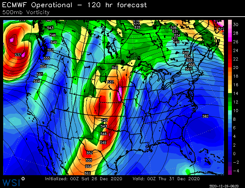
Euro did change a lot aloft though. It definitely made a step toward the less phased scenario even if t didn’t come all the way there. It wouldn’t take a whole lot more to bring the wintry scenarios into play. Check out 108h today vs 120h on the 00z run...notice up in Canada you see today’s run having a bunch of energy sheared out north of Lake Superior...that also causes the main trough to the south to become more elongated and positive tilted

-
Verbatim it’s mostly just in the high elevations but in reality it could be more widespread. I’d like to see the isobars orient the sfc front more NE to SW though for a classic icing event.
-
I’m not even sure what the 12z Ukie is doing now. It basically leaves about half the energy behind but still has some ejected into the southeast. Almost looks like it would have trouble even getting the storm this far north. That could be an icing setup though... Lol
-
Ggem whiffs on the phase too now but it still tries to track the low pretty far west. However, because it whiffs on the initial phase, it allows some high pressure to build in ahead of it so it starts to act more like a SWFE in NNE. Esp at the surface with icing. Trend that a little more and there could be a snowier solution on the table.
-
We had a massive fake-out on model guidance progged for MLk day and beyond. Looked almost like a 2015 patter and then it utterly vanished in mode guidance after being there for like a week. Thats’s when I personally felt the winter was screwed. This winter is pretty weird. The NAO is still in doubt but theres sign it eventually helps out...and if t doesn’t, there are some signs that the PAC may improve around 1/10 and beyond. Who knows for sure though. This hasn’t been a good winter for LR forecasting. Nobody saw the El Niño pattern coming from weeks out.
-
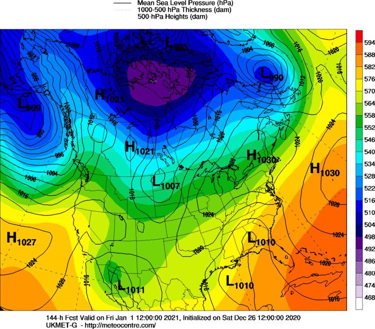
If you are grasping at straws, the 00z Ukie changed the setup for the New Years storm. Prob a decent winter storm brewing there at 144h for NNE anyway...unfortunately no other model shows this
-
Sounds kind of like voodoo. Only a couple days in the 40s would be a way below avg temp January..even in your hood. Our recent Januarys in the past 3 or 4 years have been pretty torchy though, so I can see the fatigue of warm Januarys. I guess 2019 wasn’t but all other years since 2015 have been.
-
Or late Jan ‘15/Feb ‘15
-
The models flip flopping badly gives some hope that they aren’t handling the entire evolution well in the N ATL. Hopefully one of these systems wave-breaks a nice block into the Davis Strait. Hopefully the weeklies actually have a clue and we pop that +PNA after about 1/10 because that would be a pretty nice pattern...+PNA/-NAO.
-
I mean, that’s pretty much every single winter in New England unless you are at high elevation and/or upslope region. Once in a blue moon we get winters where it’s fairly consistently good or the bad periods are short (‘00-‘01 is a good example) but they are the exception rather than the rule. A legit threat could still pop after New Years but it’s going to need more help I think than the models suggested a few days ago given the pattern deterioration.
-
NAO blocking isn’t progged like it was a few days ago. It’s well south of where it was so it doesn’t really help us. Still could change, but that’s the main reason it looks worse. PAC has always looked meh for early January.
-
Ensembles have steadily gotten worse each run for early January. We might be punting 3 weeks (roughly Xmas to Jan 10) if there’s no improvement.
-
The New Years storm has looked terrible for 2 or 3 days now. That’s a big time cutter again I think unless we get a major synoptic change (still plausible but increasingly unlikely) It’s amazing how far north that one is progged to warm sector again. That’s what has been weird about these cutters...not that they are simply cutters, we get those relatively frequently early in the season, but that they are literally pushing 50s into Quebec City with zero high pressure at all creating any resistance even in far northern New England. Meanwhile they are causing snow thicknesses deep into northern Mexico...LOL.
-
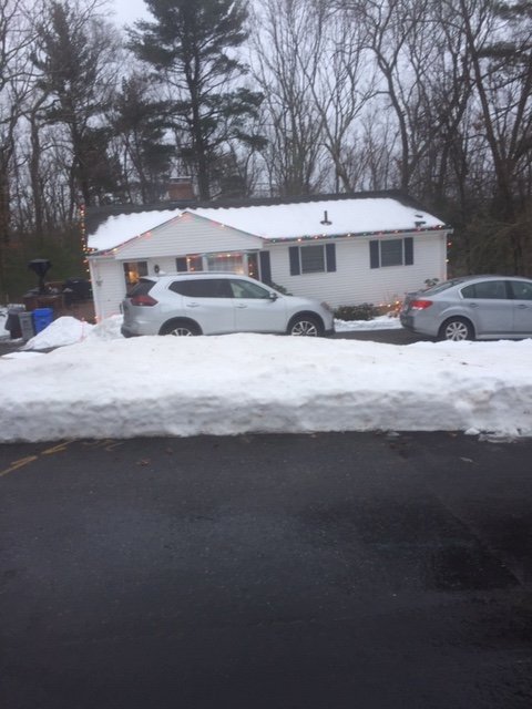
24 hour snowpack comparison (actually more like 25 hours...4pm yesterday to almost 5pm today)
-
I’d take the North Atlantic ridging with Feb climo wavelengths over a typical Feb La Niña gradient which often porks us. But who knows, maybe we get neither pattern and it’s a nice +PNA which is the best in February
-
Tropical dewpoints from the Bahamas visiting Quebec City again.
-
Jim Hughes. Don’t think i ever saw him after about 2008 or 2009. Hopefully he didn’t pass and just went elsewhere.


