

ORH_wxman
-
Posts
93,099 -
Joined
-
Last visited
Content Type
Profiles
Blogs
Forums
American Weather
Media Demo
Store
Gallery
Everything posted by ORH_wxman
-
Dec (Edit: Jan1/..2 ) multi-faceted ptype mess potential...
ORH_wxman replied to Typhoon Tip's topic in New England
It has a few hours in N CT from Kevin to your old stomping grounds before it goes to 33-34 rain. Nothing big but it doesn't take much to be dangerous for anyone driving. -
Dec (Edit: Jan1/..2 ) multi-faceted ptype mess potential...
ORH_wxman replied to Typhoon Tip's topic in New England
prob starts around midnight friday night give or take a couple hours...might be 2 or 3 inches there? Hard to say...mid-levels warm quick, but sfc stays cold. Def some sleet and ZR in there. -
The 1961 Xmas eve storm was pretty epic in parts of SNE. Over 20” in many areas.
-
Dec (Edit: Jan1/..2 ) multi-faceted ptype mess potential...
ORH_wxman replied to Typhoon Tip's topic in New England
18z euro tickled colder. Def more snow for CNE and NNE than the 12z run. Maybe a quick inch or so for the pike region too. -
Kettlebrook is a great course... But back on topic. 18z eps still interested in 1/3-4
-
Charlton is def a pretty good weenie spot ...but there’s a definite difference between them and those places to the north of them we are discussing. Esp in CAD setups with icing and pack retention. It also sounds like runnaway can’t live in the total sticks, lol....so he’s gonna have to stay pretty close to ORH proper in this hypothetical scenario.
-
Paxton MA. The town west of the airport. 1200+ feet. Real weenie spot. The only pain with the west side and towns like Paxton is that it’s not near any highways for quick travel east (if you need to get to Framingham for example)...north side of ORH and towns along 190 would be better for quick highway access.
-
No the airport is not north. It’s west side over by Tatnuck Sq. Winter hill is north-northwest side near the Holden line.
-
And i was telling you +8 for two weeks isn’t close to record warmth. You’d need to go up a lot higher than that.
-
You’ll need like +14 or 15 for a two week stretch...which would require the Davis Strait stuff to disappear. Anything’s possible but I ain’t seeing it. Maybe Caribou.
-
Oh yeah...he will def want to PM me. There’s massive difference within the city...there’s a definite N to S gradient too overall but also elevation obviously.
-
Dec (Edit: Jan1/..2 ) multi-faceted ptype mess potential...
ORH_wxman replied to Typhoon Tip's topic in New England
Wolf not howling tonight? -
He might have been issuing a forecast for the Davis Strait or northern Quebec.
-
They are a little more bullish on a Davis Strait block...and we will need it for sure the first 10 days of the month with the garbage PAC. Hopefully a better PAC materializes beyond that.
-
Underdog that it will end up a big storm, but can't rule it out. Marginal airmass (though at least it appears better than 12/5 as modeled) and a lot of shortwaves in the flow don't allow for much margin.
-
Euro develops a legit Davis Strait block in clown range around 1/7. We'll see if that can help keep things underneath us until the PAC improves. We will need it so hopefully it has the right idea.
-
I have to admit, that would send Kevin on an MLK-2010 style melt
-
H5 low tracks in Ottawa, lol....tries to redevelop SE, but I'll take this with a grain of salt obviously until we get closer.
-
Yeah it's a sloppy development....initial pulse of PVA is well west which is a red flag to me, but it doesn't really have room to amplify so it redevelops east....the QPF and clown maps will look fine, but there's a lot of moving pieces that will change over the next few days.
-
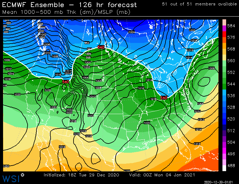
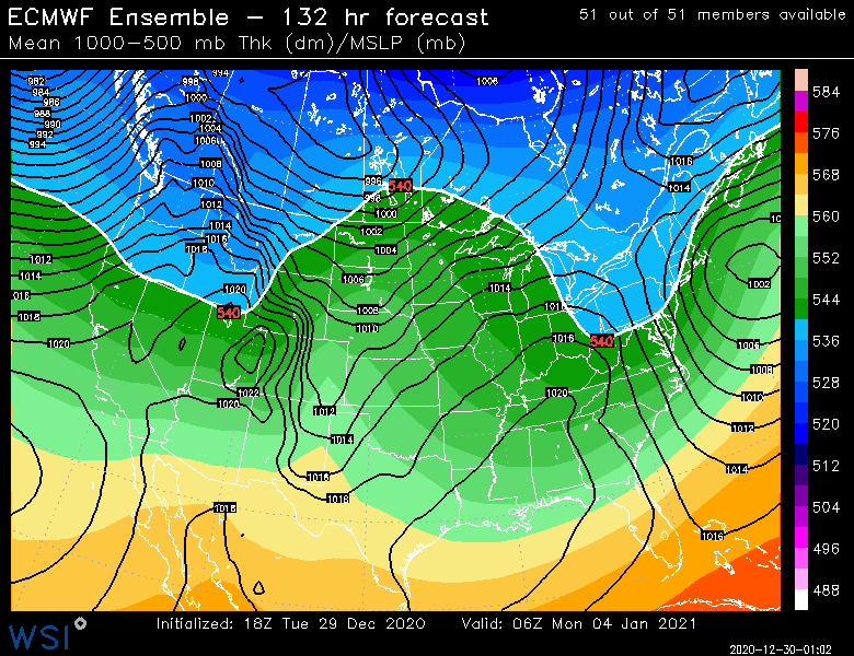
Ugly evolution on the euro for 1/4...but system is still there for sure. Something to watch.
-
Yeah that is a pretty major storm actually...prob warning snows for a chunk of the area if it ran another 6-12 hours out...esp eastern half of SNE
-
It's a little bit colder as modeled, which could potentially be a big difference in sensible wx.
-
It's good enough for interior SE NY and interior SNE.
-
Dec (Edit: Jan1/..2 ) multi-faceted ptype mess potential...
ORH_wxman replied to Typhoon Tip's topic in New England
I've mostly agreed with Scott on this threat....meh for SNE but there was an outside chance that interior spots like ORH to the berks could see something more interesting. Euro has never looked good for this icing threat in SNE....which is why I haven't really posted much on it. We saw some other guidance toy with the idea of a more impactful event, but they have trended toward the Euro (kind of predictably IMHO). Still have to watch for a few hours of glaze over the interior....even a little glaze can be a hazard. But outside of that, I don't see much. You'll have to go much further north to get some accumulating snow that breaches advisory threshold. -
Yeah don't count on building sustained pack until the PAC gets better. If 1/4 ends up pretty big, then it might last, but otherwise, we wait.

