ORH_wxman
-
Posts
93,099 -
Joined
-
Last visited
Content Type
Profiles
Blogs
Forums
American Weather
Media Demo
Store
Gallery
Everything posted by ORH_wxman
-
Significant upper middle Atlantic S/CNE mix/snow potential Jan 3+
ORH_wxman replied to Typhoon Tip's topic in New England
V16 GFS is a bit late to the party too. Not gonna get it done for anything higher than advisory stuff except for downeast. -
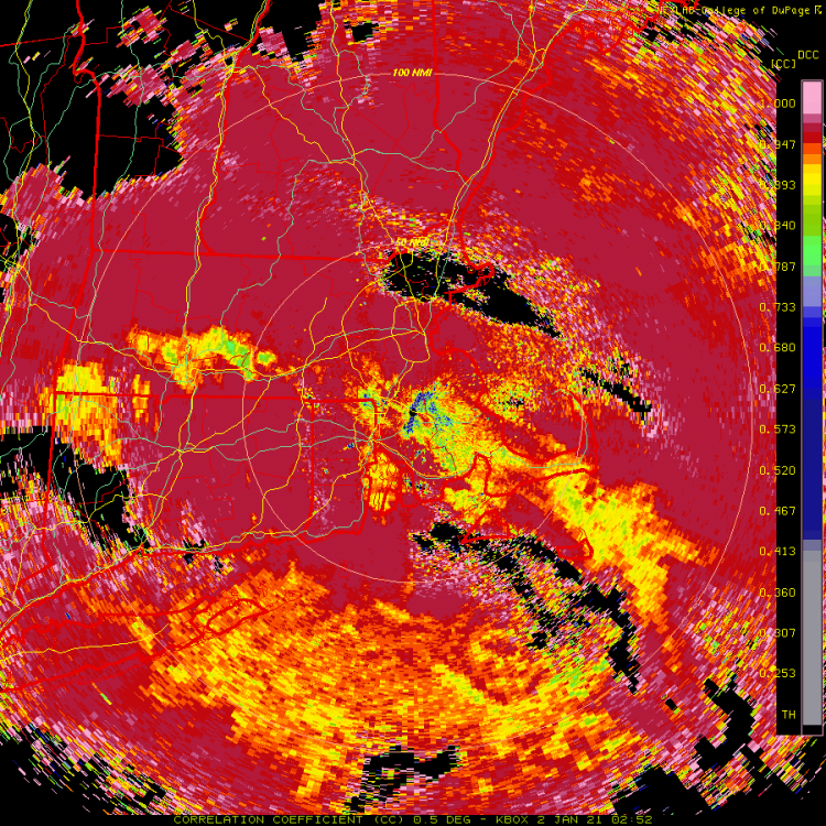
Pounding huge aggregates in this heavy band....can hear some pingers mixed in too, but it's prob 80-90% snow at the moment.
-
Significant upper middle Atlantic S/CNE mix/snow potential Jan 3+
ORH_wxman replied to Typhoon Tip's topic in New England
Kind of amazing how differently models are handling the evolution of the upper air low even 48-60 hours out. -
Sleet line trying to press northeast though it's struggling a bit southwest of ORH
-
Significant upper middle Atlantic S/CNE mix/snow potential Jan 3+
ORH_wxman replied to Typhoon Tip's topic in New England
-
Significant upper middle Atlantic S/CNE mix/snow potential Jan 3+
ORH_wxman replied to Typhoon Tip's topic in New England
Too bad we can't see a few more panels of the 3km NAM...that was about to be a real weenie solution for E MA into Maine I think. -
Absolutely ripping. PRob half an inch down. Too bad it won't last all that much longer...looks nice.
-
Weird. BOX dualpol on weathertap isn’t updating. Must be their site.
-
Already busted down south. ORH getting blitzed at the moment.
-
Of course dual pol goes down at box at a great time. No update since 8:23 (regular base reflectivity is still updating)
-
Significant upper middle Atlantic S/CNE mix/snow potential Jan 3+
ORH_wxman replied to Typhoon Tip's topic in New England
Banter y’all. -
Significant upper middle Atlantic S/CNE mix/snow potential Jan 3+
ORH_wxman replied to Typhoon Tip's topic in New England
Yeah the euro slowly getting better. You can see how close this comes to a really big hit and I’d expect a bigger solution anyway even if the upper air didn’t change. -
Significant upper middle Atlantic S/CNE mix/snow potential Jan 3+
ORH_wxman replied to Typhoon Tip's topic in New England
This first one you posted did. He’s in Methuen now not Wilmington. It’s not worth parsing over the NAM run anyway but he’d do quite well imho even if he didn’t jackpot that run. He might not get 12”+ but probably at least 8-10. -
Significant upper middle Atlantic S/CNE mix/snow potential Jan 3+
ORH_wxman replied to Typhoon Tip's topic in New England
One of the few storms you would’ve done noticeably better in Methuen than Wilmington. -
Significant upper middle Atlantic S/CNE mix/snow potential Jan 3+
ORH_wxman replied to Typhoon Tip's topic in New England
For Kevin it could easily be an advisory 3-6” event if there’s no earlier capture...he’s interior and elevated enough that it will snow with the residual WAA stuff on the front end. This airmass isn’t as bad as Dec 5th...there’s at least some dry dewpoint drain from that high to the north. If closer to the coast with little elevation then I’d want the rates to pound more. -
Significant upper middle Atlantic S/CNE mix/snow potential Jan 3+
ORH_wxman replied to Typhoon Tip's topic in New England
Not necessarily. There’s plenty of storms I’ll worry more about a scraper or whiff than an amped solution. This is definitely not one of them despite seeing several weak SE solutions on the euro. -
Significant upper middle Atlantic S/CNE mix/snow potential Jan 3+
ORH_wxman replied to Typhoon Tip's topic in New England
Doesn’t have to move NW to get a more tucked track. Just look at 18z NAM. You just need a more defined vortmax...ULL track and vortmax track are already plenty far enough NW for a hugger type solution. It’s just a matter of capturing that sfc baroclinicity early enough. -
Significant upper middle Atlantic S/CNE mix/snow potential Jan 3+
ORH_wxman replied to Typhoon Tip's topic in New England
I think he was asking from our point of view further south. -
Significant upper middle Atlantic S/CNE mix/snow potential Jan 3+
ORH_wxman replied to Typhoon Tip's topic in New England
Yes. -
Significant upper middle Atlantic S/CNE mix/snow potential Jan 3+
ORH_wxman replied to Typhoon Tip's topic in New England
Jerry's turn for the jackpot? Just wait one run if you don't like it.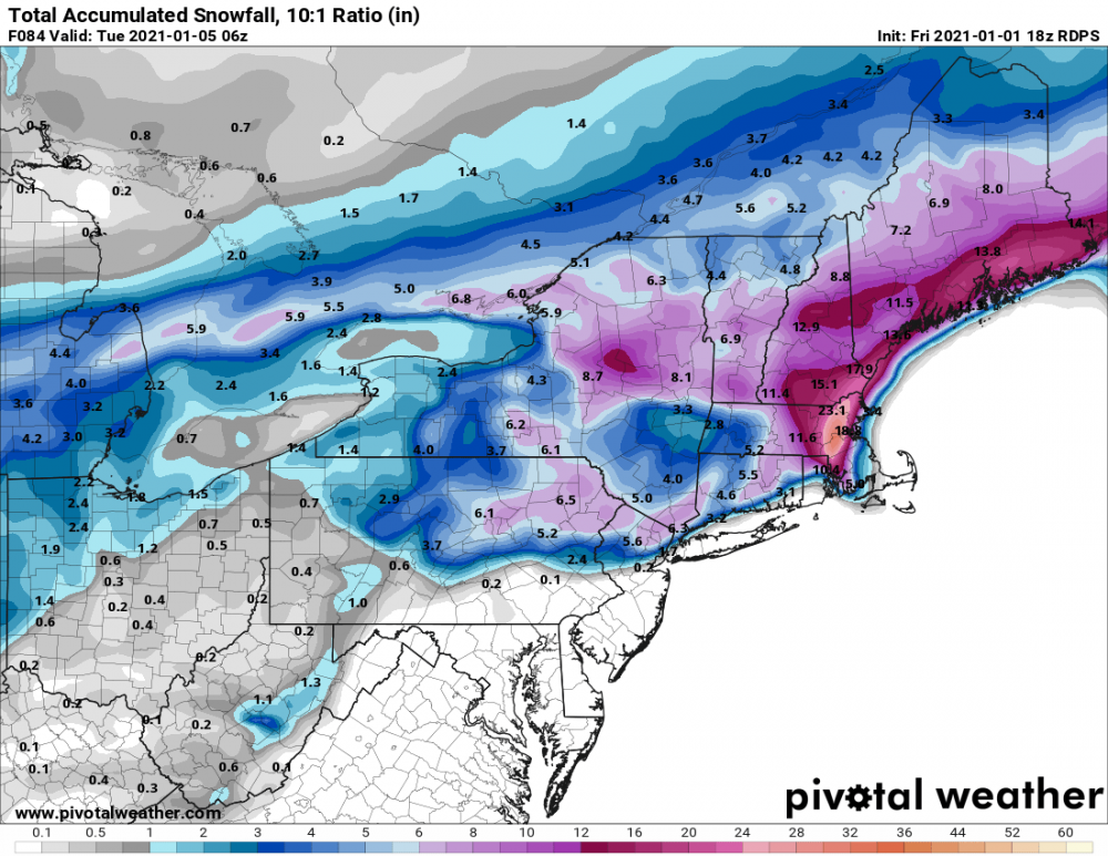
-
Significant upper middle Atlantic S/CNE mix/snow potential Jan 3+
ORH_wxman replied to Typhoon Tip's topic in New England
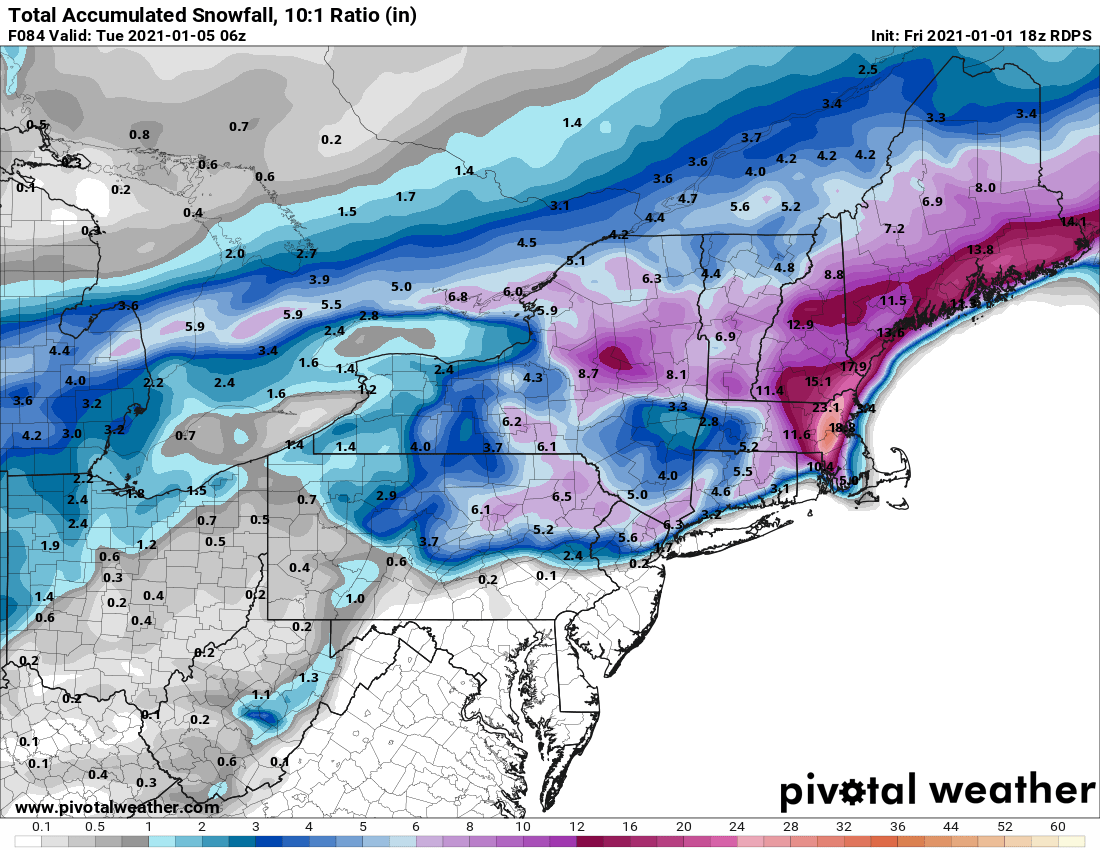
RGEM is actually going to capture it in a good spot for eastern spots...a little different than the NAM. -
Significant upper middle Atlantic S/CNE mix/snow potential Jan 3+
ORH_wxman replied to Typhoon Tip's topic in New England
RGEM not as amped as 12z so far...which isn't terribly surprising since it was one of the most amped models at 12z -
Dec (Edit: Jan1/..2 ) multi-faceted ptype mess potential...
ORH_wxman replied to Typhoon Tip's topic in New England
Cold layer below the warm tongue is pretty deep for the first several hours, so I wouldn't be surprised at a pretty good sleet-fest for a time. Esp in the zone between the pike and N CT/N RI. -
Significant upper middle Atlantic S/CNE mix/snow potential Jan 3+
ORH_wxman replied to Typhoon Tip's topic in New England
You're in a decent spot. -
Significant upper middle Atlantic S/CNE mix/snow potential Jan 3+
ORH_wxman replied to Typhoon Tip's topic in New England
You'd get like a foot-plus? What's wrong with that