ORH_wxman
-
Posts
93,099 -
Joined
-
Last visited
Content Type
Profiles
Blogs
Forums
American Weather
Media Demo
Store
Gallery
Everything posted by ORH_wxman
-
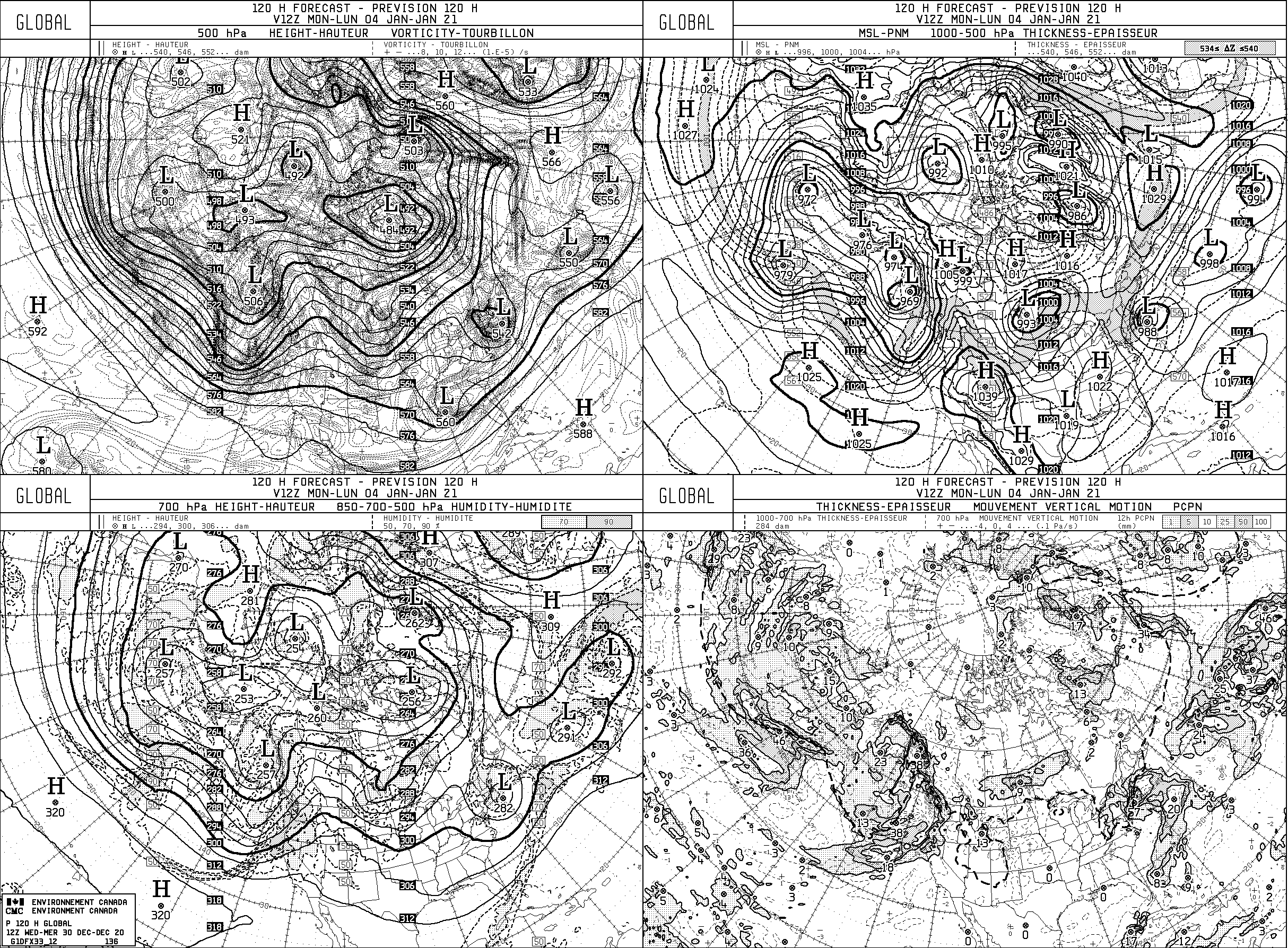
Significant upper middle Atlantic S/CNE mix/snow potential Jan 3+
ORH_wxman replied to Typhoon Tip's topic in New England
Ukie doesn't look bad at first glance....can't see thermals yet, but prob cold enough for most...at least away from water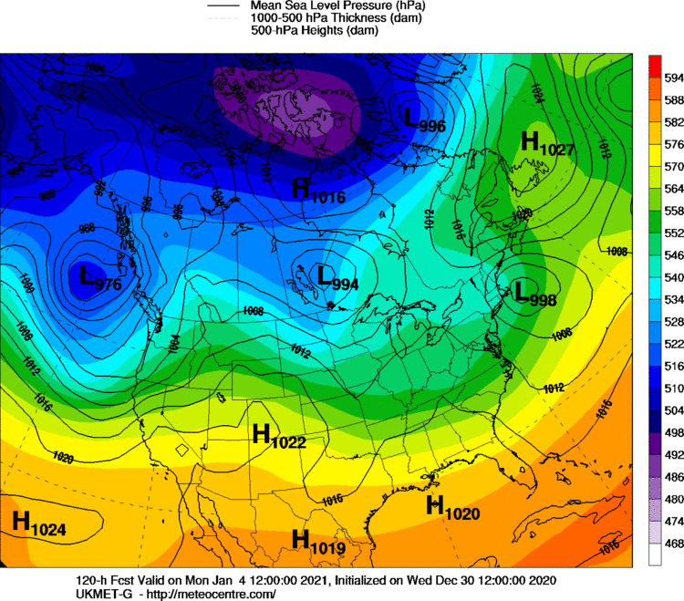
-
Significant upper middle Atlantic S/CNE mix/snow potential Jan 3+
ORH_wxman replied to Typhoon Tip's topic in New England
Yeah I looked at the H5 and then saw the QPF and was thinking "I highly doubt it...".....lol -
GFS has a miller B threat for 1/7-1/8....GGEM had this last night as well although wide right.
-
Significant upper middle Atlantic S/CNE mix/snow potential Jan 3+
ORH_wxman replied to Typhoon Tip's topic in New England
No idea, but they update quickly, lol. They literally are the EXACT same graphics as when I started looking at them in 2000 or 2001. They might have been already like that for a few years prior. -
Dec (Edit: Jan1/..2 ) multi-faceted ptype mess potential...
ORH_wxman replied to Typhoon Tip's topic in New England
v16 is pretty damned cold actually....colder than the RGEM down this way. -
Significant upper middle Atlantic S/CNE mix/snow potential Jan 3+
ORH_wxman replied to Typhoon Tip's topic in New England
SNE crush job on the GGEM.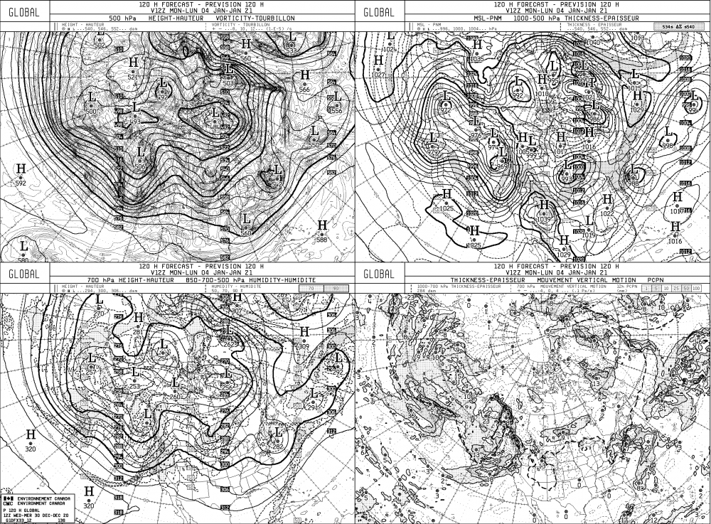
-
GFS finally starting to get precip into New England for the 1/4 threat. Light snow event for SNE this run.
-
Dec (Edit: Jan1/..2 ) multi-faceted ptype mess potential...
ORH_wxman replied to Typhoon Tip's topic in New England
Yeah ad the question is how much colder does it trend and if it does, is there enough QPF to make it matter? -
Dec (Edit: Jan1/..2 ) multi-faceted ptype mess potential...
ORH_wxman replied to Typhoon Tip's topic in New England
Colder than 06z GFS....but yeah, there's no real WAA thump of QPF. It's really weak overrunning crap. -
Dec (Edit: Jan1/..2 ) multi-faceted ptype mess potential...
ORH_wxman replied to Typhoon Tip's topic in New England
Pictures of advisory snowfall draped on the trees from Holliston to Methuen while 33F and rain in Tolland? Neighbors spot Kevin in his front yard beating the crap out of his computer office-space style with a baseball bat in his raincoat. -
Dec (Edit: Jan1/..2 ) multi-faceted ptype mess potential...
ORH_wxman replied to Typhoon Tip's topic in New England
It did well in the Dec 16-17 storm. -
Dec (Edit: Jan1/..2 ) multi-faceted ptype mess potential...
ORH_wxman replied to Typhoon Tip's topic in New England
Cold 12z RGEM run....has advisory snows almost to the pike. Really tight cutoff though...virtually zero snow south of the pike. Still not buying it yet, but may need to watch. That run was pretty much all snow from CON northward. -
Yeah you prob don't want a 2015-esque PAC with that block....though we could use it slightly better than it is. It's downright horrific so the cold is pretty marginal, it's enough for snow threats though. It would be nice to insert a little more CP airmass into the pattern....if only to freeze up the water bars and ponds/lakes quicker. Something like a Jan 2011 Pacific....it wasn't obscenely cold that month, but consistent below avg.
-
Dec (Edit: Jan1/..2 ) multi-faceted ptype mess potential...
ORH_wxman replied to Typhoon Tip's topic in New England
Yeah his jackpot fetish will peek out if he has one of the higher totals in SNE....he'll be all over it if he rips 3" in a few hours while ORH is IP/ZR and Kevin is 33F rain. -
Dec (Edit: Jan1/..2 ) multi-faceted ptype mess potential...
ORH_wxman replied to Typhoon Tip's topic in New England
If antecedent airmass aloft was like 2-3C colder, then it would be perfect. -
If the Davis Strait block sets up like we've seen on the Euro and other guidance at times, then it's a decent snow pattern. It isn't cold at all, but it's enough to get plenty of snow threats because virtually any disturbance in the flow is going to run into the block and be forced underneath it unless there's some crazy phasing.
-
Dec (Edit: Jan1/..2 ) multi-faceted ptype mess potential...
ORH_wxman replied to Typhoon Tip's topic in New England
The rapidly developing secondary cold tucks the sfc behind it....so yeah, I don't think we're getting 55F on Sunday. -
Look on the bright side....you prob just saw the worst cutter you'll see in the Dec 15-Mar 15 period you will see up there for at least a couple decades....lol.
-
Dec (Edit: Jan1/..2 ) multi-faceted ptype mess potential...
ORH_wxman replied to Typhoon Tip's topic in New England
Pike region may sleet bomb for a time....though Euro/Ukie are a bit colder and has a quick burst of mod/heavy snow for a couple hours. Kind of skeptical of the snow though unless we see another tick colder aloft. -
Who cares about the damage....the snow pack melting is what really hurt in that storm.
-
Dec (Edit: Jan1/..2 ) multi-faceted ptype mess potential...
ORH_wxman replied to Typhoon Tip's topic in New England
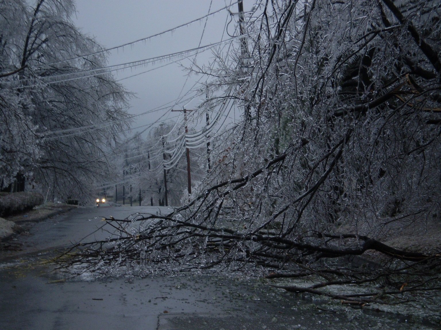
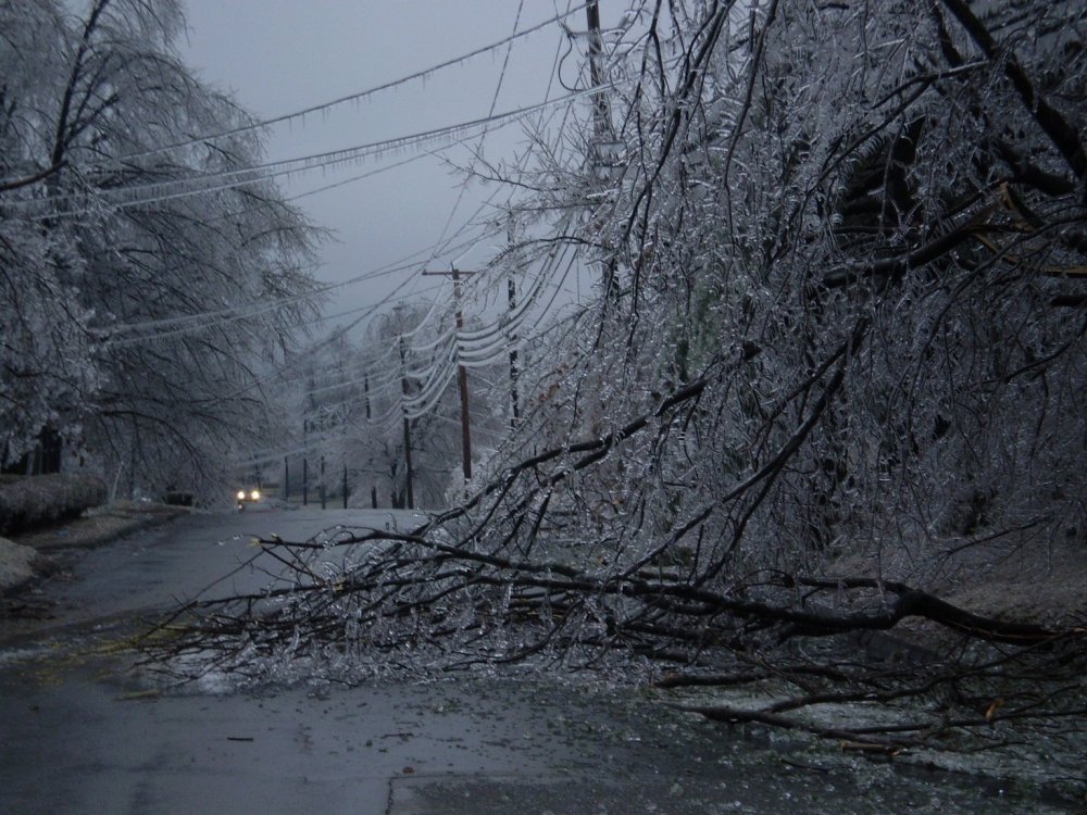
The 2008 ice storm in ORH was like that....no snow or sleet before hand or during the event....even up in N ORH county like near FIT they had some sleet or sleet/snow mix for a time which whitened the ground a little. But down in ORH it was all "clear ice" on everything.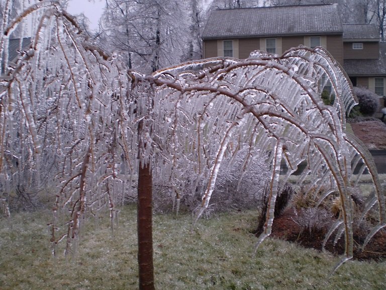
-
Def favors eastern areas for highest potential....track is near or just SE of benchmark. You'd get accumulating snow too though.
-
Dec (Edit: Jan1/..2 ) multi-faceted ptype mess potential...
ORH_wxman replied to Typhoon Tip's topic in New England
Yeah I’m sure you’ll breach 6” when you add in the upslope stuff. The synoptic stuff is good base-builder though even if it’s only 3 or 4 inches. It’s denser, especially if it’s borderline sleet or changes to sleet. -
Dec (Edit: Jan1/..2 ) multi-faceted ptype mess potential...
ORH_wxman replied to Typhoon Tip's topic in New England
Yeah euro was snowier up there than 12z run. It’s not super different from 00z NAM up there...but down here it was. Euro had a period of snow down here while NAM is mostly sleet at the onset after maybe a couple flakes. You’d still prob change to some sleet or ZR near the end but not before most of the precip thumps you as snow. It’s not a very prolific system (prob advisory type snows from the synoptic precip) but it beats rain. Lol. -
Dec (Edit: Jan1/..2 ) multi-faceted ptype mess potential...
ORH_wxman replied to Typhoon Tip's topic in New England
NAM did come in a little colder. Not quite as cold as the euro but colder than the 18z NAM. Bit of a sleet bomb for a few hours in the pike region. More snow into CNE.