Negnao
-
Posts
297 -
Joined
-
Last visited
Content Type
Profiles
Blogs
Forums
American Weather
Media Demo
Store
Gallery
Everything posted by Negnao
-
That’s the 7pm observation.
-
15z improved.
-
The Jan 31 Potential: Stormtracker Failure or 'Tracker Trouncing
Negnao replied to stormtracker's topic in Mid Atlantic
January 25, 2000 radar loop: https://mesonet.agron.iastate.edu/current/mcview.phtml?prod=usrad&java=script&mode=archive&frames=60&interval=60&year=2000&month=1&day=24&hour=0&minute=0 -
The Jan 31 Potential: Stormtracker Failure or 'Tracker Trouncing
Negnao replied to stormtracker's topic in Mid Atlantic
This has a chance to hit north as well. Need to start hoping this goes away. -
The Jan 31 Potential: Stormtracker Failure or 'Tracker Trouncing
Negnao replied to stormtracker's topic in Mid Atlantic
If we don’t get positive trends on the 12z runs it’s time to root for it to just go away. Otherwise we’re looking at it digging and cutting off and south of us and northeast of us will get snow and we’ll be left with the consolation prize of a cold and windy day. -
The fail scenario here is probably a Boxing Day type situation.
-
DCA 3.4 as of 7am.
-
January 24-26: Miracle or Mirage JV/Banter Thread!
Negnao replied to SnowenOutThere's topic in Mid Atlantic
I really hope the schools don’t close for more than a day over this. Two at the most. Hopefully they don’t inconvenience everyone if it’s just too cold in the mornings this week for school. -
Jan 24-26 Weekend Snow and Sleetfest Model Thread Part Tres
Negnao replied to H2O's topic in Mid Atlantic
If DCA gets 5 inches out of this synoptic setup that’s a huge win. Over under on Ocean City hitting 50 degrees during the storm is also interesting. -
Jan 24-26 Weekend Snow and Sleetfest Model Thread Part Tres
Negnao replied to H2O's topic in Mid Atlantic
Man if you just read the hyperbole here about the nam “improvements” and didn’t look at the run you would have thought it spit out the blizzard of 93. -
3-5 isn’t a bad outcome with a low that goes to Pittsburgh.
-
Surprised nobody mentioned how amped the 6z nam and 9z srefs are.
-
This one’s not ours. Time to face the music. It’s a Philly-NYC event.
-
Anyone know the final total at DCA? The 1.1 was at 10am. There was quite a bit more after that.
-
Good banding still at DCA. Good chance of 2 inches if measured correctly.
-
Really good returns over dc right now. Should easily be 1st inch at DCA.
-
So we swapped out the Canadian for the Gfs on our side but the Canadian has better verification scores. Lol
-
2/10 was definitely more than 20 at DCA and indeed they had an initial observation closer to what Dulles got. They then revised that observation but also acknowledged that they lost the snow board during the storm. Essentially they guessed.
-
Yes but as recently as last January DCA had a 4.1 inch storm and a 3.7 inch storm, barely missing this. And dc itself surely achieved it.
-
????? Baltimore (bwi) got 6.6 in the January storm this year as well.
-
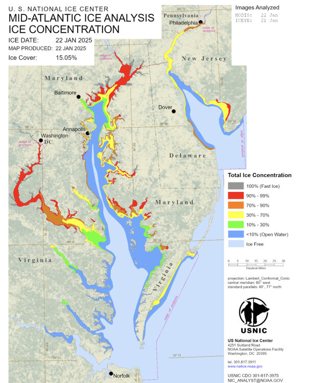
Any observations of ice on Potomac or bay? This map seems overdone.
-
This map doesn’t really tell the story that dc is on the wrong side of the thermal boundary on the hrrr for most of the event and gets saved by a nice backend band as the coastal pulls away. That’s too hard to predict.
-
DCA reported 1 inch at 1am observation but this morning the 6am observation was reported to be .7. Looks like they changed it.
-
DCA can’t be less than 7 but they are terrible with two part storms.
-
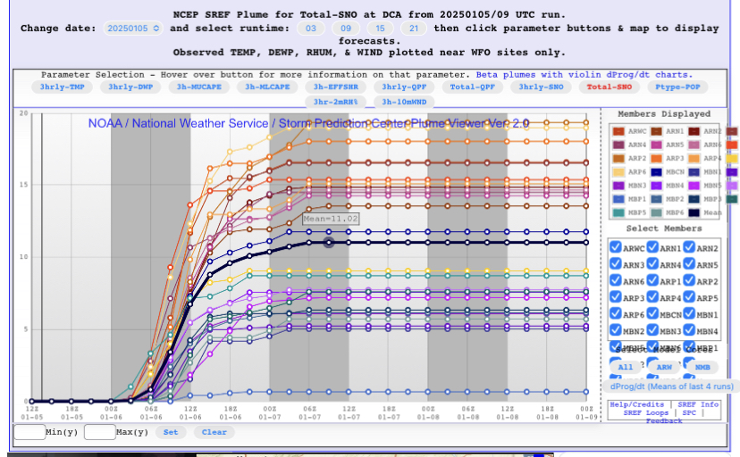
I know you guys hate the sref plumes but 11 inch mean at DCA is fun to look at.