

Newman
-
Posts
2,485 -
Joined
-
Last visited
Content Type
Profiles
Blogs
Forums
American Weather
Media Demo
Store
Gallery
Everything posted by Newman
-
HRRR develops an eyewall
-
Long range 12z HRRR is just insane, wow
-
SREFs coming in even more tucked and amped!
-
Yes it was Juno in Jan 2015. Different storm evolutions and scenarios though, that was a Miller B with a late capture. Still, a similar final outcome is still on the table though not likely.
-
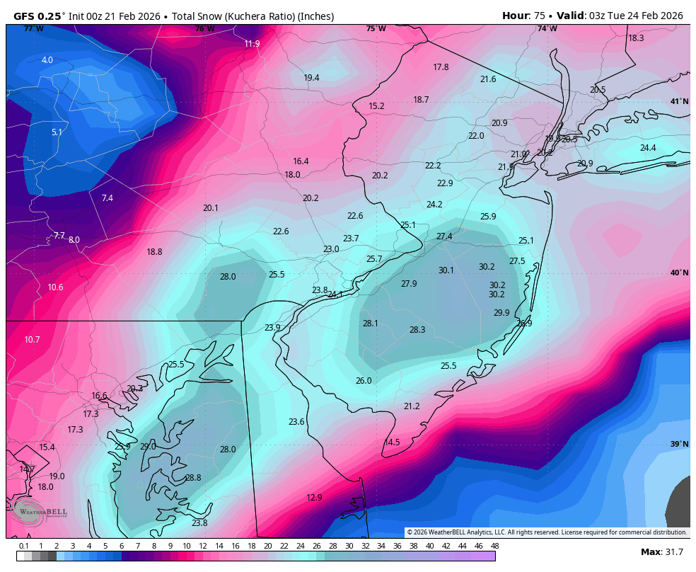
I would personally take the 12" line right up to Philly right now, just northwest of Philly 8-12, and Berks/LHV 5-8". Points along the Jersey coast will see localized 24"+. I'm leaning heavily on the Canadian guidance which is right in the middle seemingly of the GFS/Euro. I think the final solution is 20 miles west of the Canadian.
-
Really the only difference between the models is how quickly do the mid level/upper level lows fully close off. Euro is the slowest, meso models/GFS the fastest. This is exactly why I had a fear of it slipping east... Because more often than not these are "late" and end up being NYC -> Boston hits. I'm 100% not calling for whatever the hell that 0z Euro run was, in fact I'm still leaning towards a more GFS solution. But it is a valid concern and we will see at 12z here what happens.
-
I have a very hard time believing the Euro would be as east as it is with what it's giving us at the upper levels. It's essentially lock step with other guidance now, perhaps 20-25 miles further east with the h7 low passage. For folks in the Lehigh Valley and Berks, yes those 20-25 miles could be the difference between 6-8" or 12-16". For Philly SE, I think the Euro is still catching up
-
Ukie backs even further west again, precip shield looks weird and again I'd argue it could/should be better with where the h5 and H7 lows stack
-
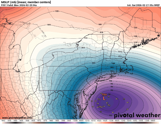
GEFS mean snowfall. Yes, ensemble MEAN.

-
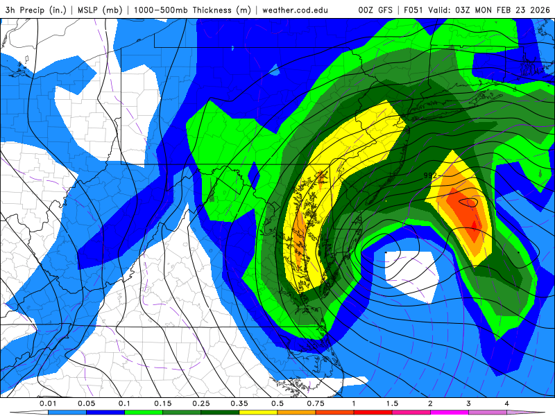
GFS mega band at 10pm Sunday. This run is gonna be insane!
-
If you look at the H5 and H7 tracks/pivot compared to th NAM, it's barely different at all. It's just banding differences and it seems like to me the RGEM is struggling with the precip output.
-
Here comes the GFS...
-
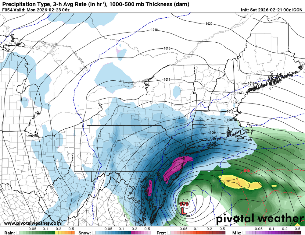
ICON!!!
-
0z FV3 GFS is absolutely insane
-
GFS is just a huge crusher
-
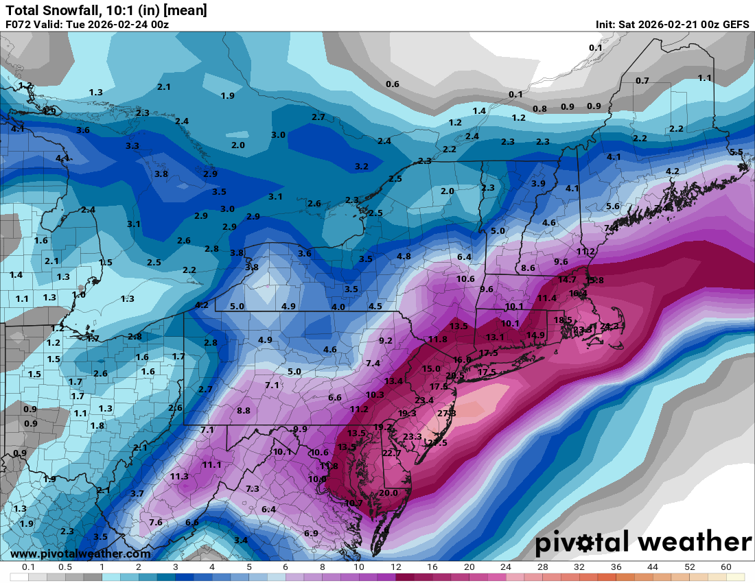
Entire state of Jersey is 18-36" on thar run, unreal!
-
18z NAM already looking much more amped
-
I know the High End snow maps can seem like weenie bait, but as an EM met they are crucial for communicating POTENTIAL impacts. In EM, we always prepare for or are staged to respond to the worst case scenario. You never want to be caught with your fly down
-
Mount Holly 90th percentile (i.e. reasonable worst case scenario)
.thumb.png.e54f5ea6bbea24f0f741077b31db97c5.png)
-
Maybe a bit bold, but I told my family in Berks and Lehigh to expect 5-8" right now. I think 3-5" is safe, but I'm thinking there could be an outer fringe 700mb fronto band that surprises. Dual band type of precip shield. Would feel even more comfortable if I was NW of 95 if the closed 700 mb low passage was tucked closer to the coast. My fear is this tries to slip east last second just based on past PTSD lol
-
Ukie with a massive shift west, gets 6-8" to Philly, 12-16" locally along the Jersey coast. 2-5" back to the Lehigh Valley
-
GEFS gonna be unchanged mostly for Philly SE, but the orientation of the more SW to NE precip shield is being reflected across the Lehigh Valley where the gradient is tighter. Probably just noise, I guess we'll see. MSLP low placements actually ticked west quite a bit on the GEFS at 12z. And I'm referring to MEAN Total QPF, so honestly there may have just been a rogue member that rained to I-95 that got removed this run
-
GFS is gonna score it's biggest coup ever here. I mean I just don't see how it doesn't at this point. 12z GFS: The trough is actually more amplified so the storm initially develops a touch further south. It tucks, but the occlusion process takes it a smidge further east this run which is why parts of the Lehigh Valley get lower totals overall (still 8-12"). The initial jet enhanced precip is also less expansive and has been trending less on the GFS, which also keeps totals lower further NW. Nitpicking here though, mostly just noise. Whichever areas get the most snow is dependent on the very fine scale phasing that occurs that we won't know for another day.


.png.44497121c75879bd8dff3948113cdeaf.png)
