

Newman
-
Posts
2,485 -
Joined
-
Last visited
Content Type
Profiles
Blogs
Forums
American Weather
Media Demo
Store
Gallery
Everything posted by Newman
-

E PA/NJ/DE Winter 2025-26 Obs/Discussion
Newman replied to LVblizzard's topic in Philadelphia Region
Holy shit CMC! -
E PA/NJ/DE Winter 2025-26 Obs/Discussion
Newman replied to LVblizzard's topic in Philadelphia Region
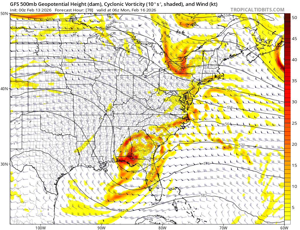
GFS just a bit too disjointed with phasing in that NS vort, verbatim it's still a huge hit for coastal Jersey. This 12z run is also completely different with how it handles that southern vort, it's amplitude, speed, etc. But I guess it goes to show that it's not a thread the needle scenario, we can score in different ways, though some locations will be favored depending on the final evolution. GFS being SE at this time though is classic, you wouldn't expect anything less. Actually looking at the final GFS solution, it's just a tad too late with fully phasing hence the strongest PVA is offshore and into Jersey -> NYC -> SNE -
E PA/NJ/DE Winter 2025-26 Obs/Discussion
Newman replied to LVblizzard's topic in Philadelphia Region
ICON starts us off great at 12z, 18-24" from Philly to NYC -
E PA/NJ/DE Winter 2025-26 Obs/Discussion
Newman replied to LVblizzard's topic in Philadelphia Region
I definitely understand the worry with an interior event, the AI GFS is essentially that. But seeing a pretty clear SE leaning cluster on Euro ensemble guidance tells me that's the most likely fail right now. Outside of the January storm, mid-range guidance has been seemingly too phase happy/amped this winter. I don't want to go against that seasonal trend based on current model guidance. We're also at that stage where we start to see storm evolutions warp, shift, and change. Probabilistically anything is on the table, and quite equally IMO. Excited for 12z runs as well -
E PA/NJ/DE Winter 2025-26 Obs/Discussion
Newman replied to LVblizzard's topic in Philadelphia Region
Have not been keeping up with this storm threat but might start doing so now that family is asking all about it ha. That 6z AIFS run is near mint perfection. Like Ralph said, a quick glance at the upper levels and you can tell the fail mode here is a slip east -
Early Monday morning 2/16 last minute event OBS/Discussion
Newman replied to The Iceman's topic in Philadelphia Region
2" in Fleetwood -
Early Monday morning 2/16 last minute event OBS/Discussion
Newman replied to The Iceman's topic in Philadelphia Region
Just a tiny difference between 12z and 18z RRFS. Something must've gotten into the NOAA mesoscale products at 12z LOL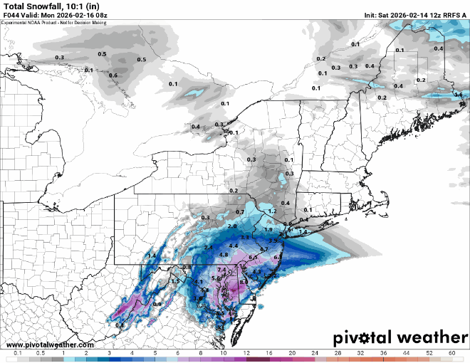
-
E PA/NJ/DE Winter 2025-26 Obs/Discussion
Newman replied to LVblizzard's topic in Philadelphia Region
Euro is a general 1-2" for most, maybe an isolated 3" in Jersey. That's what my forecast would be right now. Most accumulations on grassy surfaces, slushy inch or so on paved surfaces when rates are heavy enough. -
E PA/NJ/DE Winter 2025-26 Obs/Discussion
Newman replied to LVblizzard's topic in Philadelphia Region
Welp the NAM, HRW-FV3 suite, and RRFS are all showing real solid hits now -
E PA/NJ/DE Winter 2025-26 Obs/Discussion
Newman replied to LVblizzard's topic in Philadelphia Region
NAM is widespread 3-5", lolis of 6" across SE PA. I do think this is one of those overamped NAM runs, especially with how stark the difference in that NS wave is from last run. Really want to see Euro jump on board with a sharper NS wave. -
E PA/NJ/DE Winter 2025-26 Obs/Discussion
Newman replied to LVblizzard's topic in Philadelphia Region
I'd love to read Mount Holly's night shift AFD on this one -
E PA/NJ/DE Winter 2025-26 Obs/Discussion
Newman replied to LVblizzard's topic in Philadelphia Region
The last 5 run trend of the GFS is wild, at some point do we see this stop trending? I still think this run is over the top and we see something more like the ICON or Euro, but it's been a long time since we've seen such significant shifts in guidance to produce a *favorable* outcome within 72 hours of an event
-
E PA/NJ/DE Winter 2025-26 Obs/Discussion
Newman replied to LVblizzard's topic in Philadelphia Region
GFS is a real solid hit. Are we really doing this? Lol -
E PA/NJ/DE Winter 2025-26 Obs/Discussion
Newman replied to LVblizzard's topic in Philadelphia Region
GFS looks solid for SE PA. Like I said, keep ticking this slowly each run up until Sunday night and it's gonna be a legit storm -
E PA/NJ/DE Winter 2025-26 Obs/Discussion
Newman replied to LVblizzard's topic in Philadelphia Region
The Euro OP showing a similar shift is intriguing, as well as other guidance shifting towards it. If we can slowly tick that southern vort more progressive and that northern stream a tad slower/sharper from here until game time, we'll have a snowstorm on our hands. Still not buying it yet, but the 12z EPS is way north as well -
E PA/NJ/DE Winter 2025-26 Obs/Discussion
Newman replied to LVblizzard's topic in Philadelphia Region
Here are the individual AIFS ensembles. I counted about 24/50 members have plowable (3" or greater) snow into Philly. Just about that many have 6"+ or even 12"+ as well. Truly boom or bust. It all depends on if we phase or not with the NS wave. Let's ride member 29, 46 or 50 and call it a winter. And just to clarify, I'm not calling for a significant snowstorm with this one yet. I will need to see substantial shifts in other guidance and for the AIFS to hold the line in future runs.

-
E PA/NJ/DE Winter 2025-26 Obs/Discussion
Newman replied to LVblizzard's topic in Philadelphia Region
AIFS ENS is more tightly clustered off the Mid-Atlantic coast, QPF mean is 0.7" in Philly (some of that is probably rain at initial onset). There's probably a few big ones in the AIFS ENS individuals -
E PA/NJ/DE Winter 2025-26 Obs/Discussion
Newman replied to LVblizzard's topic in Philadelphia Region
I haven't chimed in on this threat really because it's super thread the needle, but the Euro AI has the favorable changes we need at hour 48-54 with that piece of northern energy. Also, our southern vort is a bit more progressive which allows for more constructive phasing vs destructive phasing between the two shortwaves. The flow is so progressive so I'm just not sure how we get that NS wave to phase in, but crazier things have happened -
E PA/NJ/DE Winter 2025-26 Obs/Discussion
Newman replied to LVblizzard's topic in Philadelphia Region
EPS is a 3.4" mean in Philly, 55% chance snow totals > 1", compared to only 33% at 6z -
E PA/NJ/DE Winter 2025-26 Obs/Discussion
Newman replied to LVblizzard's topic in Philadelphia Region
About 0.6" new snow in Fleetwood overnight and this morning. Current temp is 10° and dropping. Reading is currently blowing at 25 mph with gusts up to 45. -
E PA/NJ/DE Winter 2025-26 Obs/Discussion
Newman replied to LVblizzard's topic in Philadelphia Region
Long way out there, but it seems like models are hinting at two potential storm chances coming up: 2/11 and 2/15. Depending on how strong the first wave gets, it could dampen the flow and cause 2/15 to stay suppressed (ala 12z Euro AIFS). Everything will also depend on how strong the confluence holds across New England/southern Canada. Just first look seems like a SWFE would be favored with thump to ice/rain. Expect lots of changes until then -
January 30th- Feb 1st ULL and coastal storm obs
Newman replied to JoshM's topic in Southeastern States
Flurries are flying in Tallahassee, FL right now. -
West Central Florida Jan 31 - Feb 1 Winter Event
Newman replied to TPAwx's topic in Southeastern States
Looking forward to this cold here in Tallahassee. Might take a nice long walk Sunday morning in the single digit wind chills ha. The 3k NAM continues to show a Gulf effect snow band setting up across Pasco and northern Hillsborough counties around 10-11pm tomorrow. I'm excited to see the potential MCAO cloud streets across the Gulf on satellite imagery. That's something you don't see everyday!- 1 reply
-
- 2
-

-
E PA/NJ/DE Winter 2025-26 Obs/Discussion
Newman replied to LVblizzard's topic in Philadelphia Region
I had a call with some of Governor DeSantis' cabinet yesterday about the cold and potential Tampa snow flurries. People are being dumb and freaking out. True story. The extreme cold though... Not a joke. Single digit wind chills throughout North Florida, including here in Tallahassee. I'm a bit twisted and looking forward to it lol. The Ag business, not so much. Hope you picked your oranges already farmers! In PA weather news, I think KABE could very easily break the top 10 for longest stretches of temps at or below 32°, though it'll depend on Tuesday. Current forecasted high is 31 -
E PA/NJ/DE Winter 2025-26 Obs/Discussion
Newman replied to LVblizzard's topic in Philadelphia Region
Ha, I would love to hear his thoughts. I actually have no real issue with the NBM being used as a basis for the NDFD grids. In fact, I believe that's what it's really for. I just don't like how you can tell some WFOs get lazy and just send out the NBM or MOS guidance verbatim without even trying to input real climo or meteorological expertise. Also, speaking with the NWS Miami met, the NBM is being pushed programmatically in a way that it's not mandatory yet but highly encouraged. Let's be real here, what NWP guidance is even getting snow showers back to the I-95 corridor? I'd imagine very very few, and those that are are coming from the perturbed ensemble guidance like the GEFS, EPS, SREFs, etc. So right away I can tell you this forecast is heavily weighted by the NBM (which inputs those into it). In reality it could actually be a good forecast, if we believe the inevitable NW trend that hasn't commenced on guidance yet will occur so in that I give NWS Mount Holly plenty of kudos for not just sticking to the deterministic GFS and Euro. But also, I don't see any way it snows back to I-95 this weekend outside of a miracle personally..thumb.png.5d0d208b9cd380111bfe6246d0c77cae.png)


.png.b8bd1739341fca22561627c8000f09ab.png)