

Newman
-
Posts
2,485 -
Joined
-
Last visited
Content Type
Profiles
Blogs
Forums
American Weather
Media Demo
Store
Gallery
Everything posted by Newman
-

E PA/NJ/DE Winter 2025-26 Obs/Discussion
Newman replied to LVblizzard's topic in Philadelphia Region
The thing I like better about the post 1/22 timeframe is there's much easier ways to score vs playing the fickle game of hoping a vort rounds the trough at just the right time. With solid blocking developing and a decent Pacific, you shove the PV into Southeast Canada but also roll it on its side so it acts as an area of confluence and locks in deep cold across the northern tier. Essentially, it's a great overrunning signal. The ensembles have actually been enthused for that period. -
E PA/NJ/DE Winter 2025-26 Obs/Discussion
Newman replied to LVblizzard's topic in Philadelphia Region
One of the most insane fantasy runs I've ever seen on the 18z GFS -
E PA/NJ/DE Winter 2025-26 Obs/Discussion
Newman replied to LVblizzard's topic in Philadelphia Region
Overnight models showing a pretty reasonable "fail mode" in the fast flow we're in... 1. All of the PVA escapes east of the low and 2. The trough struggles to turn negative and fully consolidate due to the kicker system. In the end, it just turns into a paltry ULL passage with light snows. Even if a coastal low does pop, it's so far removed from any moisture. That's not to say the current OP runs are horrible, if the "floor" is a light 2-3" event with jacks to 6, that's fine. But some of the bigger solutions will only pan out if we can get this more consolidated. -
E PA/NJ/DE Winter 2025-26 Obs/Discussion
Newman replied to LVblizzard's topic in Philadelphia Region
The top CIPS analog from the 12z GFS is 1996 lol. No I'm not forecasting or even implying this could reach to that level. -
E PA/NJ/DE Winter 2025-26 Obs/Discussion
Newman replied to LVblizzard's topic in Philadelphia Region
Ha, well 2016 was one. I know 2021 had h500 closed off but it wasn't vertically stacked. -
E PA/NJ/DE Winter 2025-26 Obs/Discussion
Newman replied to LVblizzard's topic in Philadelphia Region
EPS last 3 runs trend. Again as is, the 12z Euro still gives much of the Lehigh Valley 4-8" of snow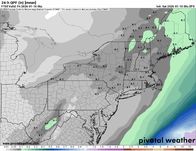
-
E PA/NJ/DE Winter 2025-26 Obs/Discussion
Newman replied to LVblizzard's topic in Philadelphia Region
Even as is interior locations get widespread 4-8". Tighten it up a bit more and it's the GFS -
E PA/NJ/DE Winter 2025-26 Obs/Discussion
Newman replied to LVblizzard's topic in Philadelphia Region
Very close, EPS will be telling -
E PA/NJ/DE Winter 2025-26 Obs/Discussion
Newman replied to LVblizzard's topic in Philadelphia Region
Like the 12z GFS advertised, yes if the energy diving down the ridge can cut off, it'll vertically stack and just crawl along the coast. What helps the GFS is that shortwave energy is super amped and dives meridionally down the ridge, so it amplifies the heights out ahead of it through PVA and T-advection very sharply, and then so much so that the trough cuts off. -
E PA/NJ/DE Winter 2025-26 Obs/Discussion
Newman replied to LVblizzard's topic in Philadelphia Region
Alot is dependent on what that TPV lobe does. The Canadian is vastly different from the GFS and dives that south into the country, the GFS scoots it east. Ideally, we want it to get out of the way like the GFS and just let the energy consolidate/cut off on its own -
E PA/NJ/DE Winter 2025-26 Obs/Discussion
Newman replied to LVblizzard's topic in Philadelphia Region
Yep, quite a few more legit storms on the GEFS. If this trend continues, we'll probably reach an inflection point. Still don't trust the GFS fully, but at least there's something on our side and all models at 12z have been improvements, some significant -
E PA/NJ/DE Winter 2025-26 Obs/Discussion
Newman replied to LVblizzard's topic in Philadelphia Region
Somehow the 12z GFS just became even more amped than 0z. Wow! Should be a great run. Probably brief rain to snow as the bowling ball rolls underneath -
E PA/NJ/DE Winter 2025-26 Obs/Discussion
Newman replied to LVblizzard's topic in Philadelphia Region
Check out the 12z GFS coming in, should be good news here -
E PA/NJ/DE Winter 2025-26 Obs/Discussion
Newman replied to LVblizzard's topic in Philadelphia Region
Admittedly I hadn't looked at the individual ensembles until now. You're right, the 0z Euro only had maybe 4 indis that even showed a coastal scraper. Haven't seen the 6z yet -
E PA/NJ/DE Winter 2025-26 Obs/Discussion
Newman replied to LVblizzard's topic in Philadelphia Region
Remember last February where the models were showing a HECS in the 120-160hour range, and then they completely backed off in literally like one model cycle after it was clear the massive TPV wasn't going to phase properly with our southern vort? That's what could happen again here, but maybe we trend more favorably? Just have to watch it play out -
E PA/NJ/DE Winter 2025-26 Obs/Discussion
Newman replied to LVblizzard's topic in Philadelphia Region
I think having a 51 member ensemble will inherently result in a pretty smoothed look over what is a fickle setup and truly boom or bust. However, even a few more ticks towards the GFS on the Euro ENS will probably start to yield at least some light upper level snows. Ride the ensembles though, them having nothing shows the low probability of this happening until we see more support -
E PA/NJ/DE Winter 2025-26 Obs/Discussion
Newman replied to LVblizzard's topic in Philadelphia Region
The Euro has been ticking slowly to the GFS for the 15-16th deal. We really need the southern vort to not get stuck behind the northern energy or else you get destructive wave interference. The 6z Euro jumped closer to better phasing and more favorable orientation. Continue watching for now, I don't think we've seen the final solution yet (for better or for worse). The 0z GFS was bonkers and probably the ceiling lol
-
E PA/NJ/DE Winter 2025-26 Obs/Discussion
Newman replied to LVblizzard's topic in Philadelphia Region
Well obviously the Jan 7-10th period isn't going to work out and we've regressed back to maybe around the 1/13-1/17 period or so for winter weather prospects returning. However, ensembles aren't too keen on any real help in the NAO department (perhaps a weak -NAO just to keep lower heights in Canada). So although we have a more favorable EPO/Pacific regime, which will help to bring the cold back, we might see a lot of waves zip down the ridge out west and slide quickly through the Mid-Atlantic. With no anomalous -NAO, there won't be opportunity for any 50/50 lows to settle into place. So yes there could definitely be snow in mid-January (as long as we don't regress any more), though I don't see any big wound up coastal storm chances outside of a rogue double/triple phaser if the northern and southern streams cooperate, though chances of that are slim with the faster flow. Perhaps a faster flow advisory or low-end warning type event. Things start looking better around 1/22, assuming the MJO progresses how I think it will. The 12z Euro for 1/15 looks close on the h500 maps with some phasing going on, though in reality there's the kicker system on its heels pushing everything quickly east so the trough can't turn negative. We're still 9 days out though so a lot will change from now to then -
E PA/NJ/DE Winter 2025-26 Obs/Discussion
Newman replied to LVblizzard's topic in Philadelphia Region
The big ones get sniffed out 8-10 days ahead of time. I remember tracking 2016 for what seemed like ages. The emotional rollercoaster ride when everything shifted south, only for the NAM to score a coup on bringing it further north within the last 2-3 days. Obviously the pattern coming up Jan 6-10th or so looks unreal with the retrograding NAO block and split flow, but details are TBD if there's good timing with short waves in the flow. If we can get a solidly timed PNA spike WITHOUT a shortwave kicker screwing things up, I truly think the ceiling is some of the big uns in history. Just go back and look at the preloading patterns of the biggest storms for PHL, DCA, BWI, NYC, etc Edit just to add: In no way am I guaranteeing a KU, but it's gotta be encouraging seeing some semblance of a pattern that can support said larger storms vs. Pac puke and zonal flow. Or cold and dry Northwest flow -
Boxing Night Snow/Sleet/Ice Dec 26-27 Storm Thread/Obs.
Newman replied to Mikeymac5306's topic in Philadelphia Region
Definitely time for nowcasting. The models are usually never perfect in nailing the warm nose and the timing of said warm nose. Who knows, maybe it comes in heavier and colder so areas thump for an hour or two and pick up more snow? Or maybe the warm nose is deeper and it's more freezing rain vs sleet? We'll see. -
Boxing Night Snow/Sleet/Ice Dec 26-27 Storm Thread/Obs.
Newman replied to Mikeymac5306's topic in Philadelphia Region
1-2" of snow/sleet looks like a good bet for most. Latest 12z HRRR is 0.4-0.5" of QPF area wide. With 3:1 sleet ratios, that'll get you the 1-2" of accumulation. Let's say something like the 0z FV3 comes to fruition which keeps the warm nose/WAA a bit muted, then perhaps in heavier rates you could stay snow longer for some areas and eek out an additional inch of snow. But the latest 12z FV3 came in with a lot of sleet. -
Saturday night/Sunday 12/13-12/14 Jawn
Newman replied to Ralph Wiggum's topic in Philadelphia Region
Really a great performance from the RRFS and HRRR which were highlighting the 6-8" strip somewhere across SE PA early yesterday morning -
E PA/NJ/DE Winter 2025-26 Obs/Discussion
Newman replied to LVblizzard's topic in Philadelphia Region
7.1" on the season in Fleetwood now, about 3 weeks ahead of normal -
Saturday night/Sunday 12/13-12/14 Jawn
Newman replied to Ralph Wiggum's topic in Philadelphia Region
5.75" in Fleetwood -
Saturday night/Sunday 12/13-12/14 Jawn
Newman replied to Ralph Wiggum's topic in Philadelphia Region
Wow! I just checked the radar loop and your area has been under the best banding all night. Love it.


