Newman
-
Posts
2,485 -
Joined
-
Last visited
Content Type
Profiles
Blogs
Forums
American Weather
Media Demo
Store
Gallery
Everything posted by Newman
-

E PA/NJ/DE Autumn 2025 Obs/Discussion
Newman replied to PhiEaglesfan712's topic in Philadelphia Region
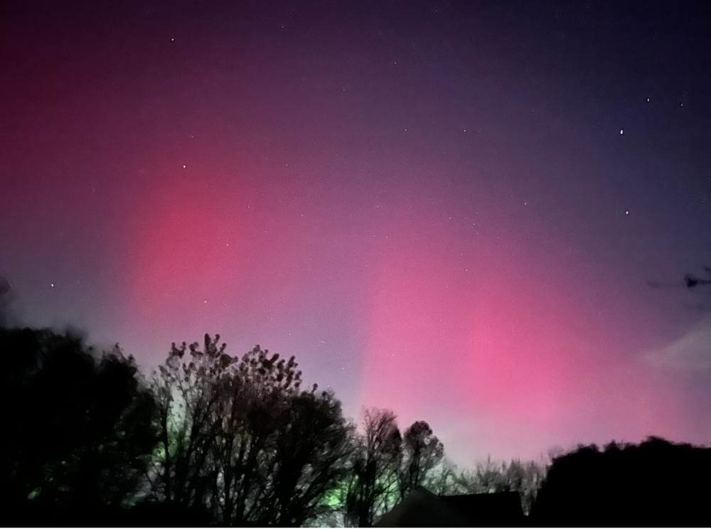
The red pillars were naked eye visible, couldn't believe it! Hoping tonight is even better, but we'll see. -
E PA/NJ/DE Autumn 2025 Obs/Discussion
Newman replied to PhiEaglesfan712's topic in Philadelphia Region
Took this at 9:13 PM EST last night from Florida From my folk in Fleetwood around the same time:
-
Tallahassee FL tonight

-
E PA/NJ/DE Autumn 2025 Obs/Discussion
Newman replied to PhiEaglesfan712's topic in Philadelphia Region
Although the chances of a KU are inherently lower in a Niña with a less active subtropical jet, we've seen some big ones in Niña winters such as 1996 and, a few years ago, Feb 2021. My biggest concern for this winter is a relentless Pac Jet which is helping to push along this brief cold snap this week. We had a perfectly timed rossby wave break that dislodged a piece of the Polar Vortex southward into the Eastern US, amplified by a peaking +PNA ridge. But too much energy crashing into the west coast is keeping the flow too fast, so this deep trough is unable to deepen and turn negative as the ridge out west breaks down quickly. I feel like that will be a theme this winter... The Western ridge breaking down too soon. I hope I'm wrong though! I'm favoring a near-normal snowfall year for Philly which will feel well above average compared to recent years. -
https://nowcastjobs.com/ Filter by any of the industries listed, this site is made specific for the atmospheric sciences/meteorology
-
Major Hurricane Melissa - 892mb - 185mph Jamaica landfall
Newman replied to GaWx's topic in Tropical Headquarters
Impacts in St. Johns/SE Canada from Melissa will largely depend on how far west it can get. The strongest winds will likely remain on the east side of the storm, so a miss east would keep any hurricane force gusts off the coast, though TS wind gusts would still be certain in areas -
Major Hurricane Melissa - 892mb - 185mph Jamaica landfall
Newman replied to GaWx's topic in Tropical Headquarters
The dropsonde with the crazy winds came from the South/Southeast eyewall, the backside winds are going to be equally as intense -
Major Hurricane Melissa - 892mb - 185mph Jamaica landfall
Newman replied to GaWx's topic in Tropical Headquarters
The center of the eye will actually go west of him -
Major Hurricane Melissa - 892mb - 185mph Jamaica landfall
Newman replied to GaWx's topic in Tropical Headquarters
11am update still 185mph, 892mb -
Major Hurricane Melissa - 892mb - 185mph Jamaica landfall
Newman replied to GaWx's topic in Tropical Headquarters
Yeah the jog north here right before landfall will get Josh head on in the eye -
Major Hurricane Melissa - 892mb - 185mph Jamaica landfall
Newman replied to GaWx's topic in Tropical Headquarters
1935 Labor Day was the strongest ever Atlantic landfalling hurricane, by pressure, at 892mb. This will tie or surpass that. -
Major Hurricane Melissa - 892mb - 185mph Jamaica landfall
Newman replied to GaWx's topic in Tropical Headquarters
There's the 10am update. WOW. 892mb and 185mph -
Major Hurricane Melissa - 892mb - 185mph Jamaica landfall
Newman replied to GaWx's topic in Tropical Headquarters
Another thing to be reminded of... Much of Jamaica is well above sea level. For example, Mandeville (which could get raked by the eastern eyewall) has a population of 47,000 people or so and is at an elevation of 620 meters (2,000 feet). So I would absolutely expect higher gusts in those locations -
Major Hurricane Melissa - 892mb - 185mph Jamaica landfall
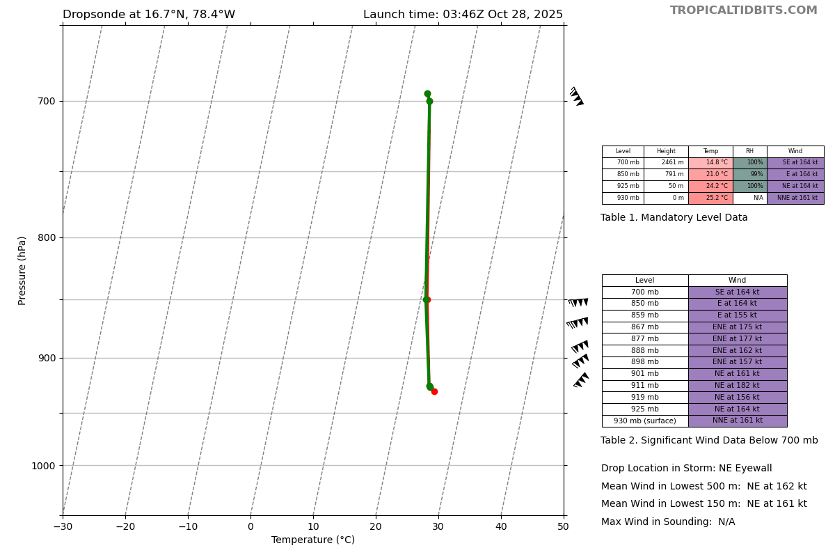
Newman replied to GaWx's topic in Tropical Headquarters
NE Eyewall Sonde. 160(!) knot surface winds?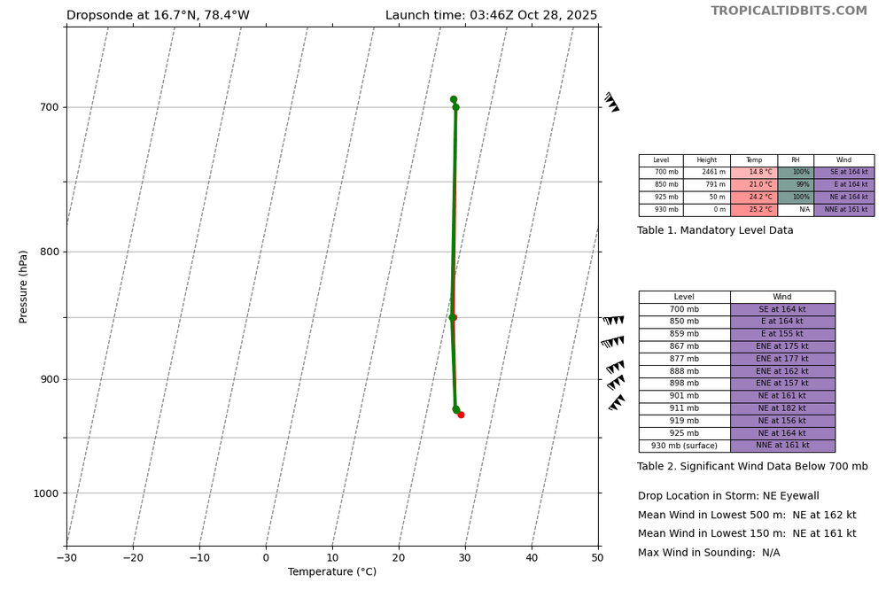
-
Major Hurricane Melissa - 892mb - 185mph Jamaica landfall
Newman replied to GaWx's topic in Tropical Headquarters
What looks like the coldest cloud tops we've seen yet wrapping around the southern CDO right now. Probably -95°C, maybe colder. -
Major Hurricane Melissa - 892mb - 185mph Jamaica landfall
Newman replied to GaWx's topic in Tropical Headquarters
11:00 PM EDT Mon Oct 27Location: 16.6°N 78.5°WMoving: NNE at 2 mphMin pressure: 903 mbMax sustained: 175 mph -
Major Hurricane Melissa - 892mb - 185mph Jamaica landfall
Newman replied to GaWx's topic in Tropical Headquarters
On Friday I listened to a briefing from the chief meteorologist for the Jamaican weather service and, at that time, the *center* of the NHC cone kept Melissa skirting around the western side of Jamaica. And in his briefing he stated "Right now, Jamaica should be protected as Melissa goes around the island". Like no sir, that's THE CENTER of the storm. Impacts are wayyyy outside the cone. I audibly gasped at his statement. I really really hope they are prepared for this. -
Major Hurricane Melissa - 892mb - 185mph Jamaica landfall
Newman replied to GaWx's topic in Tropical Headquarters
Cat 3, 4, 5... Whatever the landfalling intensity is, I'm sure much of Jamaica does not have infrastructure built to withstand major hurricane winds. Really hoping a worst case scenario (i.e. right eye wall traverses through Kingston) doesn't happen. -
Major Hurricane Melissa - 892mb - 185mph Jamaica landfall
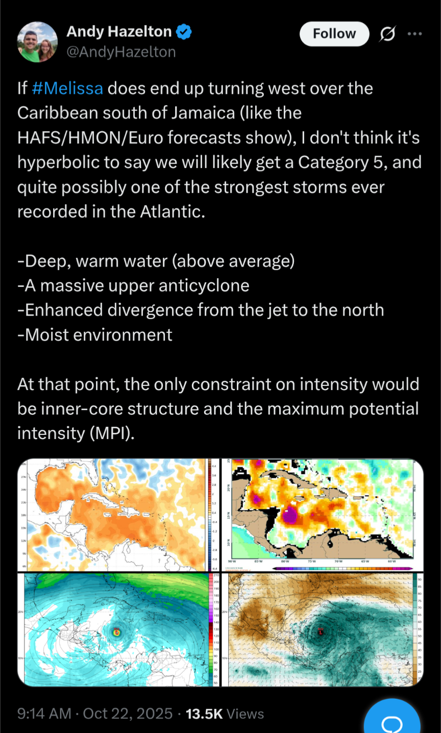
Newman replied to GaWx's topic in Tropical Headquarters
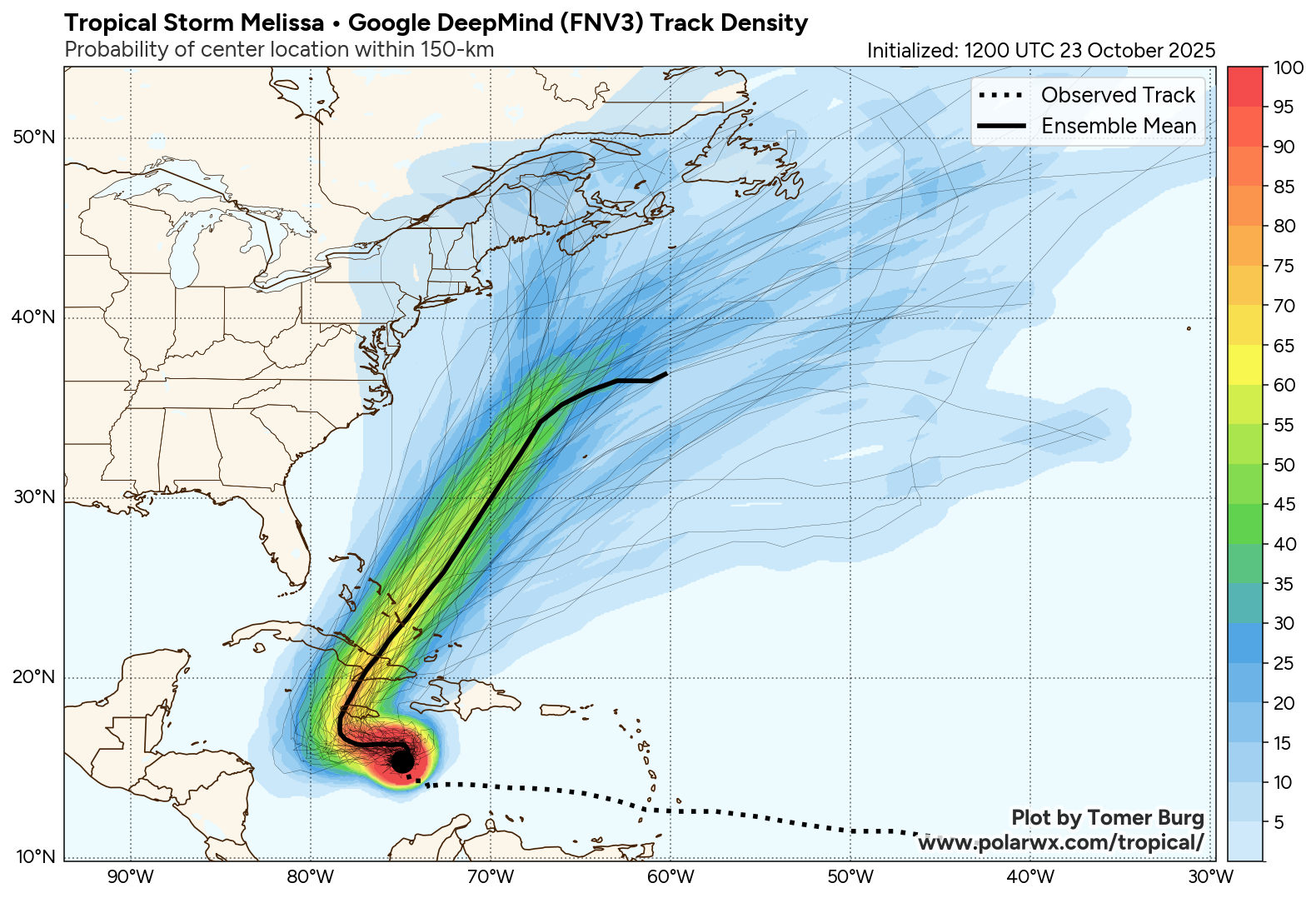
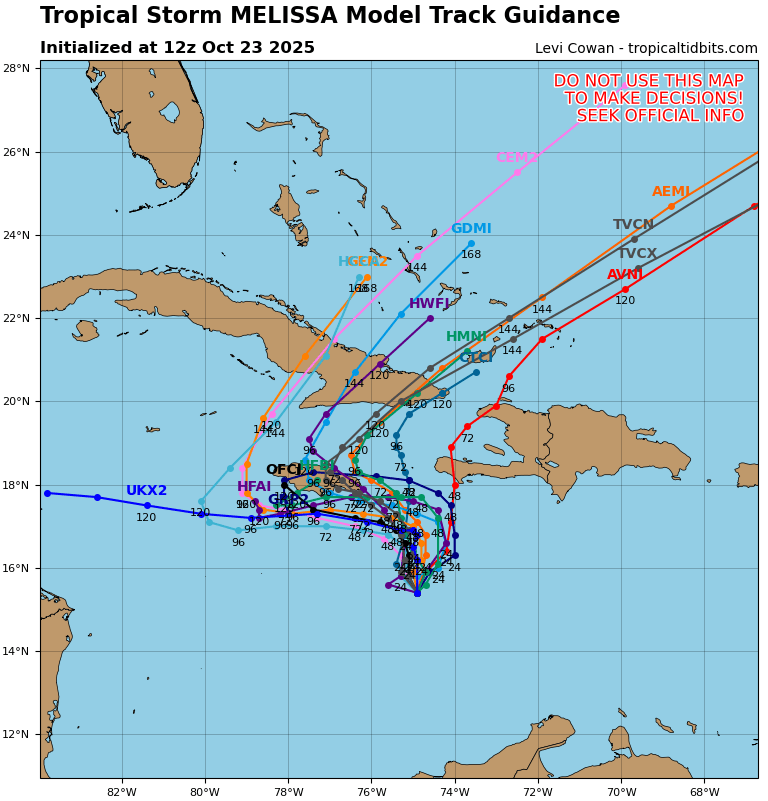
12z Google DeepMind And 12z Google GenCast The *current* consensus is to slide it towards Western Jamaica before it turns north
-
Major Hurricane Melissa - 892mb - 185mph Jamaica landfall
Newman replied to GaWx's topic in Tropical Headquarters
I'd also want to emphasize that until Melissa starts to vertically stack and become better organized, there may continue to be disagreement in model guidance in the short-term because of their proposed placement of the final organized, stacked circulation. -
Major Hurricane Melissa - 892mb - 185mph Jamaica landfall
Newman replied to GaWx's topic in Tropical Headquarters
Quite a shift east in the past day or so on the spaghetti hurricane guidance. The turn to the west is much shorter duration and Melissa gets pulled north and northeastward much quicker.
-
Major Hurricane Melissa - 892mb - 185mph Jamaica landfall
Newman replied to GaWx's topic in Tropical Headquarters
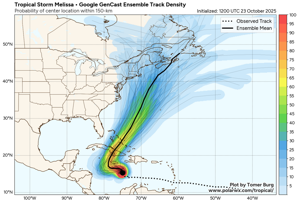
Here's the 12z EPS for reference. Right now, follow the ensembles. The clustering/highest probabilities keep it well off the coast. This is a complex setup and there will be lots of moving parts. The chance of a New England impact is still very low, but I do believe worth keeping an eye on. We've already seen this tropical season major shifts in guidance in the 7-10 day range vs what actually happened.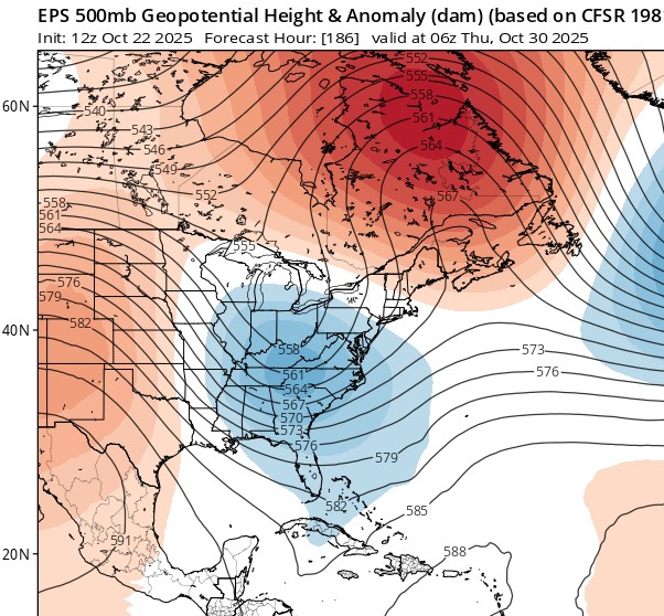
-
Major Hurricane Melissa - 892mb - 185mph Jamaica landfall
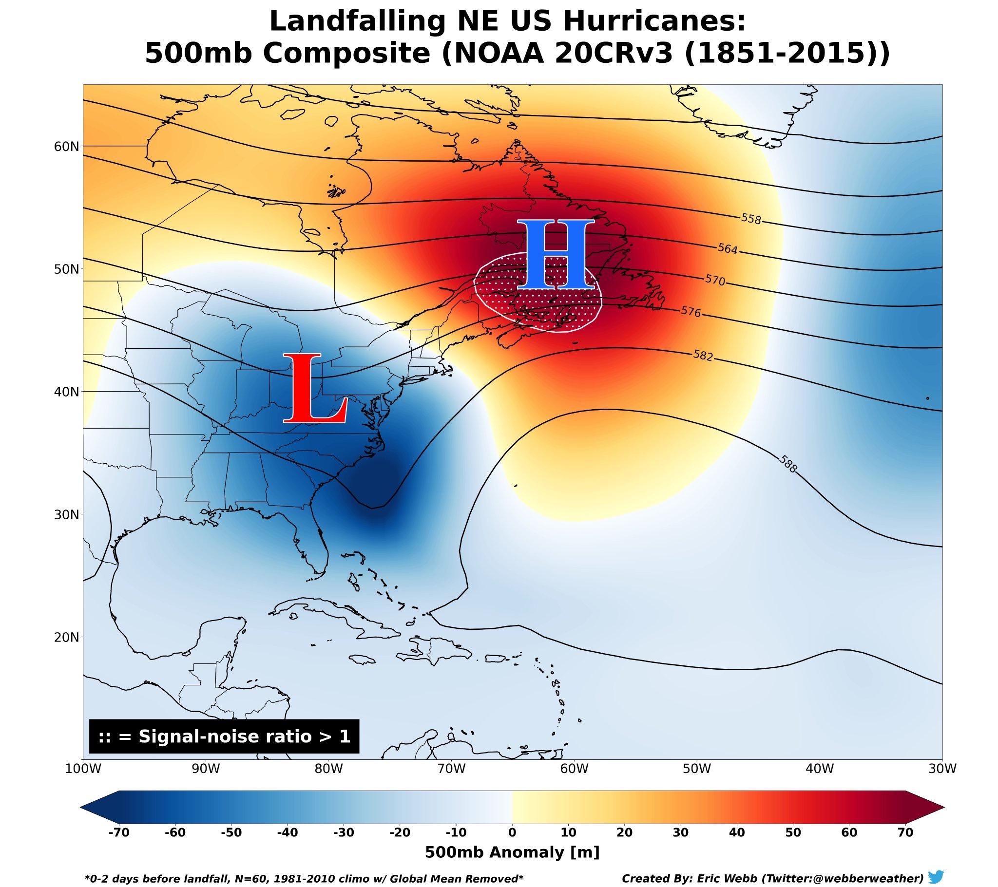
Newman replied to GaWx's topic in Tropical Headquarters
Just a reminder of what the typical upper level setup looks like for New England landfalling hurricanes. Obviously this is a broad brushed composite, but there are a lot of similarities to the currently forecast upper-level pattern from the EPS. New England hurricanes are rare for a reason - even if the overall larger pattern supports the possibility, the smaller details, exact placement of trough/ridges, etc. will have a role in impact (i.e. trough interaction) vs no impact (less trough interaction)
-
E PA/NJ/DE Autumn 2025 Obs/Discussion
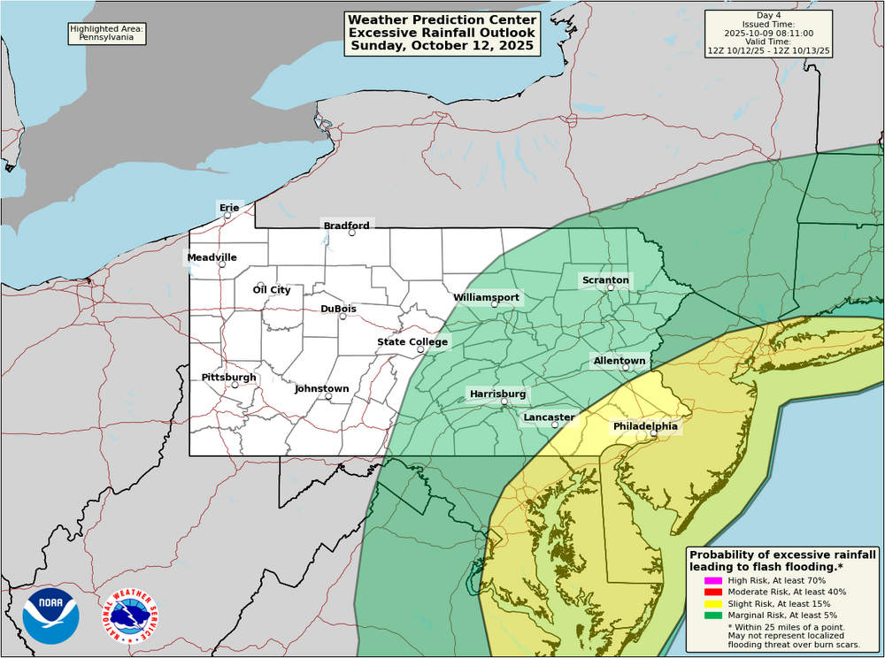
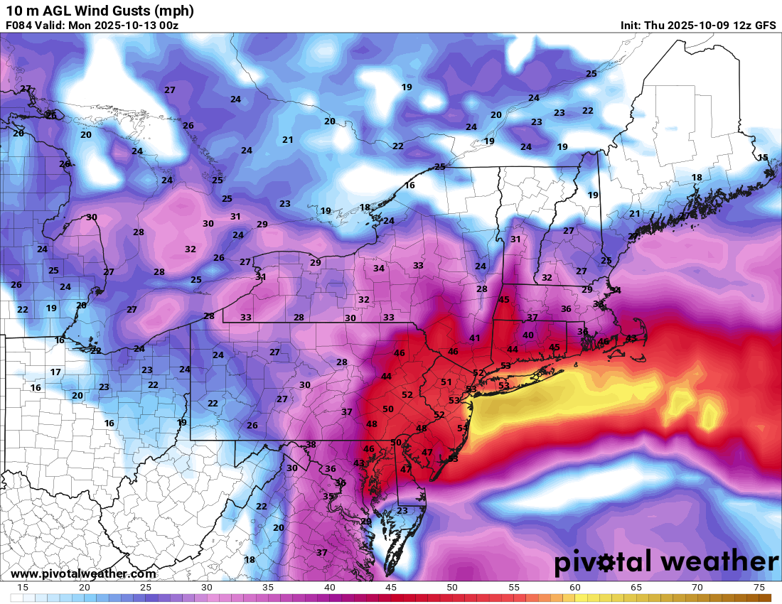
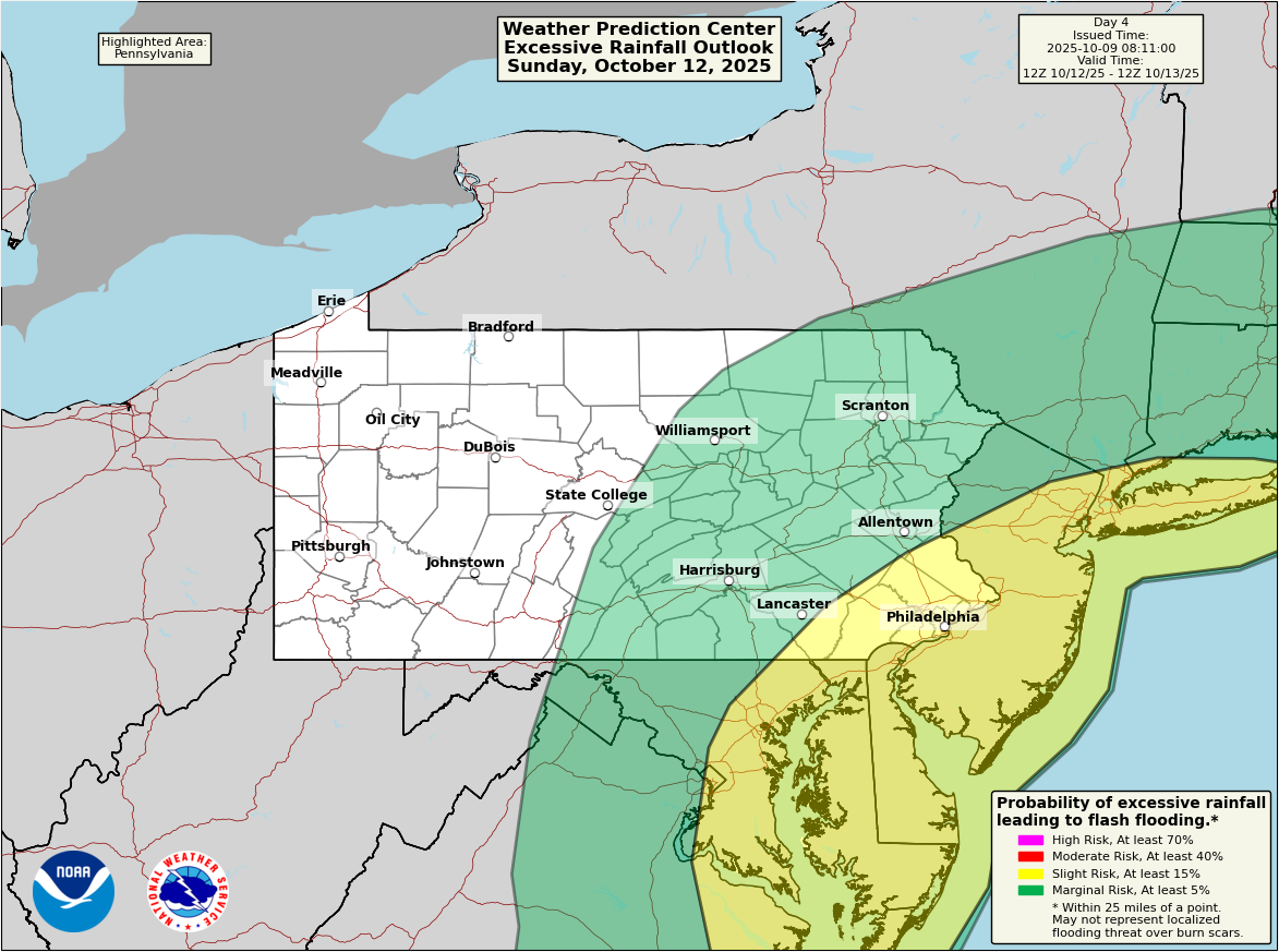
Newman replied to PhiEaglesfan712's topic in Philadelphia Region
That 12z GFS run is crazy for Jersey and much of SE PA. Verbatim, 40-55mph wind gusts extend across the Lehigh Valley and SE PA starting around noon on Sunday and lasting until noon on Monday. The most intense period from Sunday evening through the overnight hours. There is an inversion that will limit how much the strong winds aloft mix down to the surface. However, even 925mb winds are 45-50kts so any heavier showers/storms won't have any issues mixing those down. 850mb winds are closer to 65-70kts, which I haven't seen any guidance suggest those mix down beyond the immediate coastline in isolated gusts. Rainfall wise, WPC showing a slight risk for flash flooding on Sunday for the I-95 corridor and Jersey. Current forecast is widespread 1.5-3 inches of rain with higher amounts along the coast possible. Lots of time for changes to the track of the system, which will shift where the heaviest rains and strongest winds occur.