Newman
-
Posts
2,500 -
Joined
-
Last visited
Content Type
Profiles
Blogs
Forums
American Weather
Media Demo
Store
Gallery
Everything posted by Newman
-
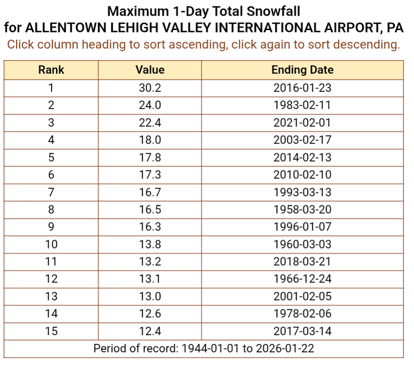
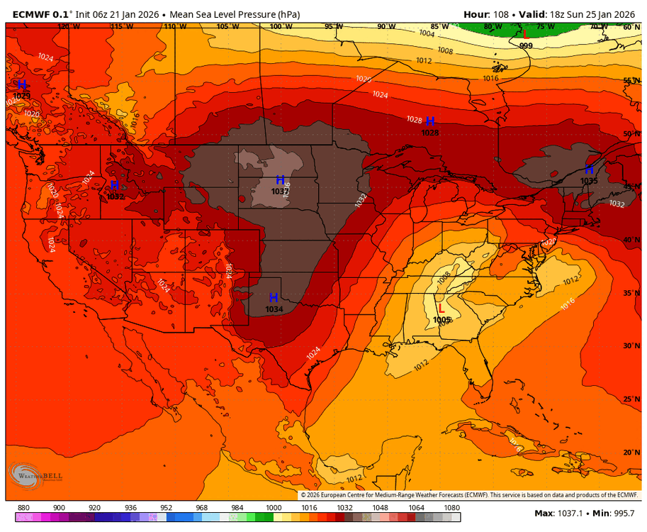
Here are the top 15 snowiest days (i.e. 1-day period) in recorded history at KABE dating back to 1944. This storm could very easily break into the top 15, or even top 10. Most if not all snow falls between 2am to 10pm Sunday.
-
Looks like Mount Holly included Berks for the 10-15" warning in the area between I-78 and I-95. And then areas along/near I-95 and south it's 8-12". North of I-78 it's 12-18".
-
I still like my Adams -> Dauphin -> Schuylkill -> Carbon -> Monroe call as to where the southern edge of the jackpot zone might set up. You want to be on the north side of the 850mb fronto and unfortunately I could see poor snow growth/crystal habit in the sinking air south of that fronto band. However, it is encouraging seeing things start to tick south and colder
-
Lol, the FV3 is super cold. That is its typical bias though so I wouldn't put much stock in it. It's got the sleet line still south of Philly by 0z Monday. Significant snows north of that across all of SE PA verbatim
-
By 1pm Sunday it also has significantly more snow across the area. It doesn't look like a timing difference to me, just more QPF and better ratios/rates.
-
Wow the 12z NAM just made a jump towards the GFS evolution, keeping things a bit more strung out and transferring to the coast sooner. Still gets the sleet line up to Central Berks county, but no further north. And then things crash back south with more to come early Sunday night. This is probably the NAM doing NAM things, but fun to see and if we see models tick that way at 12z, I might give it credence. Will need quite a few more ticks to see a lot of snow on the backside, the dry slot still kills anything past 03z
-

E PA/NJ/DE Winter 2025-26 Obs/Discussion
Newman replied to LVblizzard's topic in Philadelphia Region
6z GFS is big time for Feb 1 -
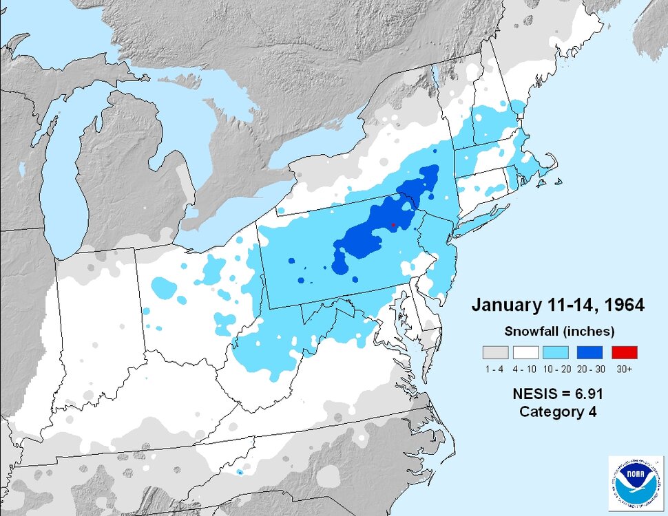
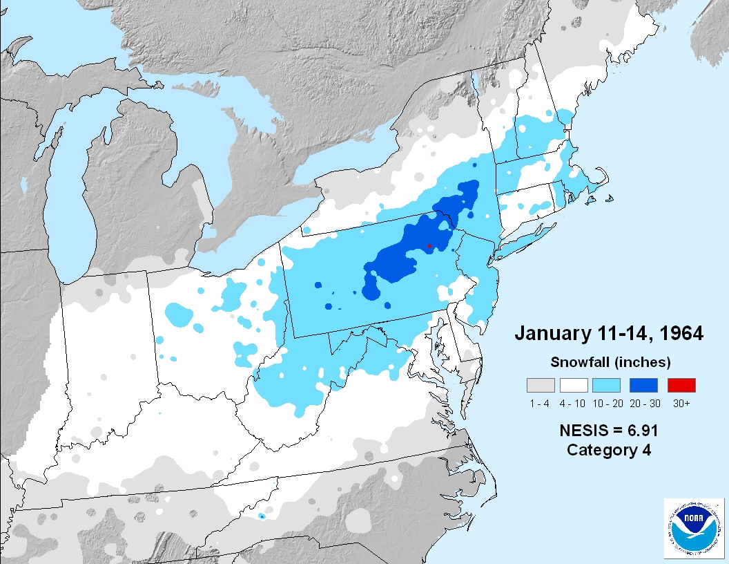
If the GFS is right, we will easily see this storm rank way up there on the NESIS scale. Below is Jan 1964 which is 8th on the list. And this storm could have an even more widespread 10"+ swath. Just something fun to think about. What really makes or breaks how high up these storms get on the NESIS list is how much snow DC, Philly, NYC, and Boston proper get. Because the NESIS equation specifically takes into account population AND how much snow said populations get
.thumb.png.1f45073816a27bebf9f7ff48c5a8b1c9.png)
-
The 18z Euro AIFS did make a small nod to the GFS in that it kills off the primary and transfers to the coast sooner
-
GFS looks nice but I'm not believing it. It's what you'd expect it to show at this stage with its typical progressive bias. With the snow last Sunday here in Florida, it trended significantly more amped just within 24 hours of the event.
-
Like Mike said above, looks like IP to me!
-
I would personally go 10-14" right now for Berks, briefly ending as sleet for up to 1-2 hours at most. I think the highest amounts end up along an arc through Adams -> Dauphin -> Schuylkill -> Carbon -> Monroe counties... so just north of Berks and Lehigh counties. I am personally expecting a slightly more north warm nose than what the NWS is currently forecasting, but if I am wrong and it stays all snow then 12-16" (as it says in their WSW) is right on the money. I think the ceiling is around 18" under a perfect scenario, the floor is around 8" if things really start to shift north. I haven't seen any guidance spit out more than 1.1-1.2" of QPF. A storm average 15:1 ratio with 1.2" QPF gets you 18" if it's all snow.
-
Absolutely, if we get heavy enough precip we could see that sleet line crash south at times. Though it depends on how potent that warm nose really is. Will be very interesting watching correlation coefficient radar for that Sunday.
-
I would really not be worrying at all about freezing rain in this system, outside of some freezing drizzle as the storm departs and we get the dry slot. When you look at the soundings, there's a barely above freezing warm nose at 750-700mb. Sleet will be the concern if we flip. I think some of the website model algorithms are off.
-
GFS is pretty much a hold from the last run, remains our coldest guidance
-
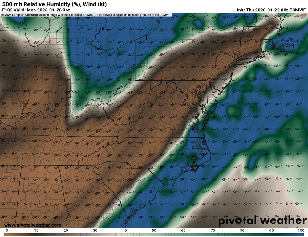
Convection Allowing Models
-
At the surface, high pressure has actually ticked stronger and further south at storm onset with deeper CAD down the spine Of the Appalachians. This can certainly help with keeping the sleet at bay, but again the warm nose is up at at 700mb level so it can only do so much if we still drive the primary up into WV or SW PA.
-
Ticked colder, so did the 06z Ukie with heights lower/confluence stronger over southern Canada.
-
GEFS and GFS are near mint perfect, which has me nervous because they're always cooler and more progressive. We're going to see some crazy QPF bombs with our CAMs in the next few days.
-
If the current evolution holds, there will definitely be a dry slot that quickly shuts off precip. Euro has it coming in almost immediately behind the initial thump.
-
All the caveats apply to the long range NAM, but it's got the sleet line up to the M/D line by 18z Sunday at hour 84 and quickly moving north. Much more significant CAD at 850 keeping things colder in that layer, but 700s above freezing. Still though, all of SE PA already has 0.7-0.9" QPF before any flip to sleet. Places further north would thump for much longer, the coastal transfer was occurring
-
Places NW of the mix line are still 100% in play to see totals near 15-18in, and that could easily set up still across the Lehigh Valley or even just NW of I-95. Even if this thing continues to trend towards a glorified SWFE, some places could grab 12" in just 4-6 hours if the models are correct. There was a SWFE quite a few years back (don't remember which one) where Berks grabbed 8-10" in 4-5 hours. Just extend the duration on this one.
-
Starting to get concerned about the way this is evolving, but would love to get through the next 0z and 12z runs to hopefully tick back south. There's no breathing room anymore for I-95 and Philly crew, and teetering on the edge for Lehigh Valley. No reason anyone should cliff jump yet though, we haven't even gotten into the NAM range
-
What I'm really interested in monitoring in modeling over the next couple days, outside of the typical synoptic features: 1. How does the heavy WAA banding translate northeastward towards SE PA? Does it weaken as the primary dies off and the coastal transfer occurs, or does it plow through the area with vigor? 2. Where do our DGZ layers (could be more than one) set up and do we have any deep omega through these layers? Even if the surface is frigid, poor snow growth could still occur if the omega and DGZ do not align. 3. Where the 700mb FGEN band sets up on models, because IRL it almost always ends up further north
-
GFS is a great run, longer duration too as you leave a bit of energy trailing. You get the southern energy to ride up along the baroclinic zone with PVA pointed across the region, and then the central Plains trough swings through. 24-30 hour event for many. A widespread 12-20" from DC to Boston hasn't happened in quite some time.


.png.d61b49bef2b172758a2d37eb89054d36.png)