Newman
-
Posts
2,500 -
Joined
-
Last visited
Content Type
Profiles
Blogs
Forums
American Weather
Media Demo
Store
Gallery
Everything posted by Newman
-

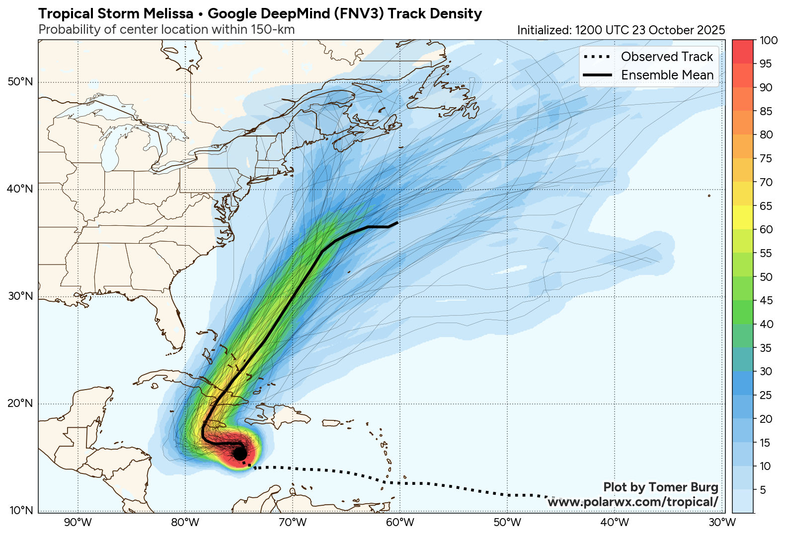
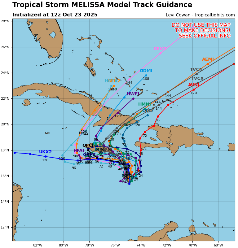
Major Hurricane Melissa - 892mb - 185mph Jamaica landfall
Newman replied to GaWx's topic in Tropical Headquarters
11:00 PM EDT Mon Oct 27Location: 16.6°N 78.5°WMoving: NNE at 2 mphMin pressure: 903 mbMax sustained: 175 mph -
Major Hurricane Melissa - 892mb - 185mph Jamaica landfall
Newman replied to GaWx's topic in Tropical Headquarters
On Friday I listened to a briefing from the chief meteorologist for the Jamaican weather service and, at that time, the *center* of the NHC cone kept Melissa skirting around the western side of Jamaica. And in his briefing he stated "Right now, Jamaica should be protected as Melissa goes around the island". Like no sir, that's THE CENTER of the storm. Impacts are wayyyy outside the cone. I audibly gasped at his statement. I really really hope they are prepared for this. -
Major Hurricane Melissa - 892mb - 185mph Jamaica landfall
Newman replied to GaWx's topic in Tropical Headquarters
Cat 3, 4, 5... Whatever the landfalling intensity is, I'm sure much of Jamaica does not have infrastructure built to withstand major hurricane winds. Really hoping a worst case scenario (i.e. right eye wall traverses through Kingston) doesn't happen. -
Major Hurricane Melissa - 892mb - 185mph Jamaica landfall
Newman replied to GaWx's topic in Tropical Headquarters
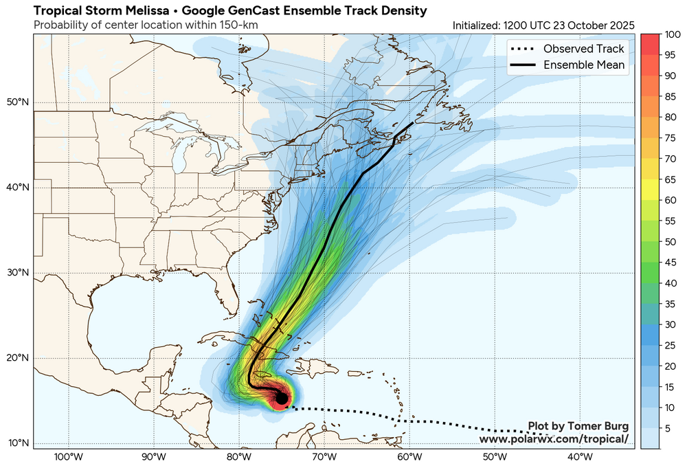
12z Google DeepMind And 12z Google GenCast The *current* consensus is to slide it towards Western Jamaica before it turns north
-
Major Hurricane Melissa - 892mb - 185mph Jamaica landfall
Newman replied to GaWx's topic in Tropical Headquarters
I'd also want to emphasize that until Melissa starts to vertically stack and become better organized, there may continue to be disagreement in model guidance in the short-term because of their proposed placement of the final organized, stacked circulation. -
Major Hurricane Melissa - 892mb - 185mph Jamaica landfall
Newman replied to GaWx's topic in Tropical Headquarters
Quite a shift east in the past day or so on the spaghetti hurricane guidance. The turn to the west is much shorter duration and Melissa gets pulled north and northeastward much quicker.
-
Major Hurricane Melissa - 892mb - 185mph Jamaica landfall
Newman replied to GaWx's topic in Tropical Headquarters
Here's the 12z EPS for reference. Right now, follow the ensembles. The clustering/highest probabilities keep it well off the coast. This is a complex setup and there will be lots of moving parts. The chance of a New England impact is still very low, but I do believe worth keeping an eye on. We've already seen this tropical season major shifts in guidance in the 7-10 day range vs what actually happened.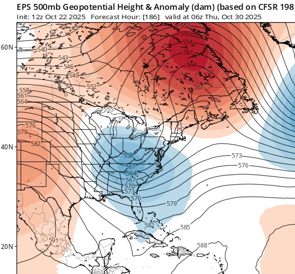
-
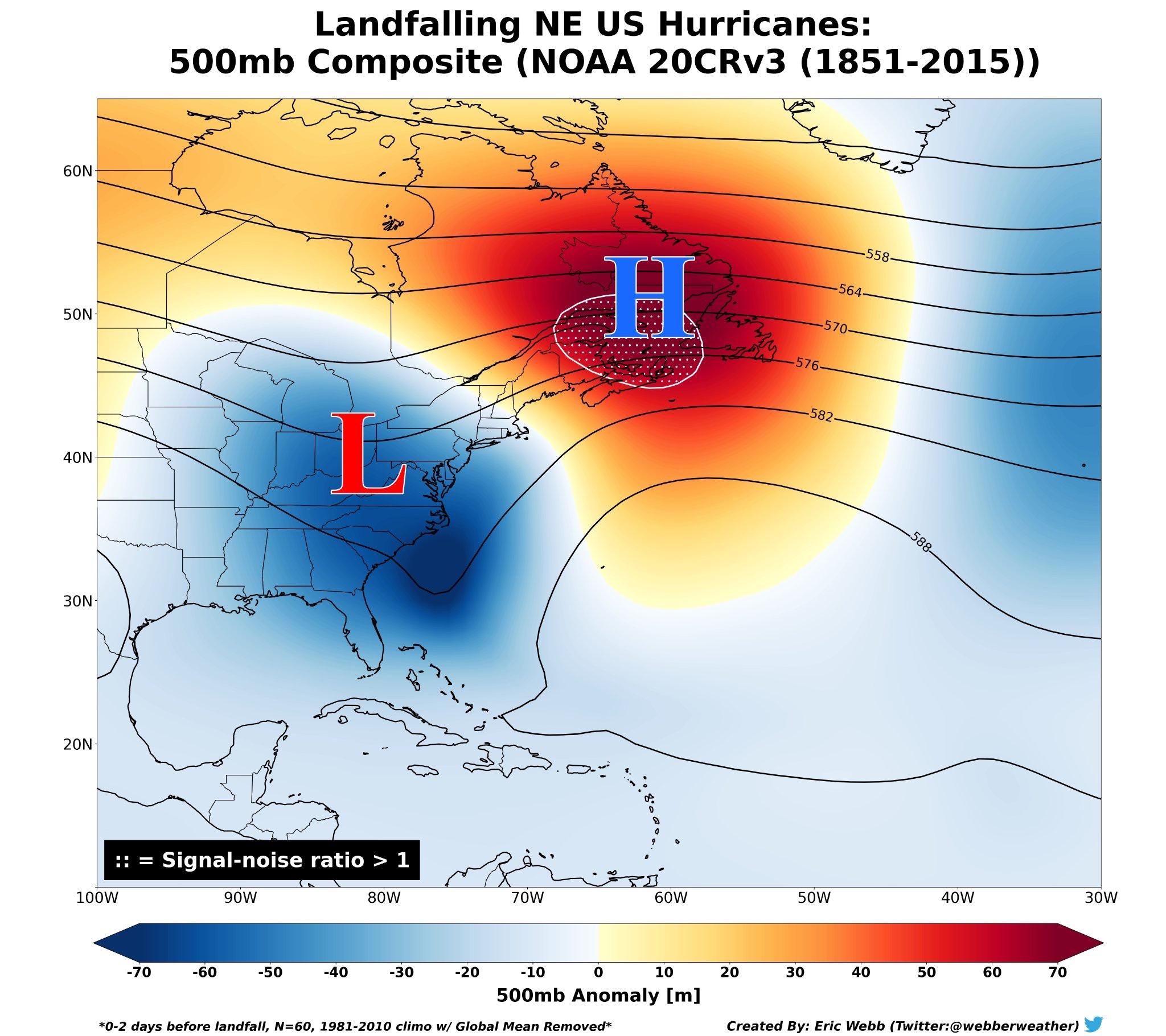
Major Hurricane Melissa - 892mb - 185mph Jamaica landfall
Newman replied to GaWx's topic in Tropical Headquarters
Just a reminder of what the typical upper level setup looks like for New England landfalling hurricanes. Obviously this is a broad brushed composite, but there are a lot of similarities to the currently forecast upper-level pattern from the EPS. New England hurricanes are rare for a reason - even if the overall larger pattern supports the possibility, the smaller details, exact placement of trough/ridges, etc. will have a role in impact (i.e. trough interaction) vs no impact (less trough interaction)
-
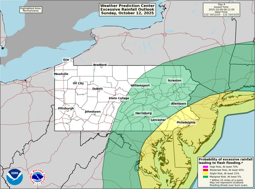
E PA/NJ/DE Autumn 2025 Obs/Discussion
Newman replied to PhiEaglesfan712's topic in Philadelphia Region
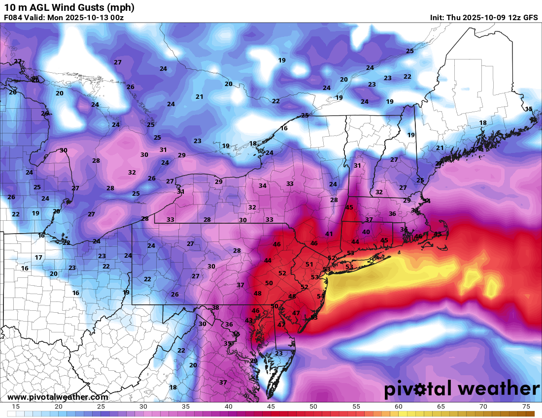
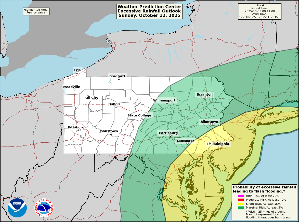
That 12z GFS run is crazy for Jersey and much of SE PA. Verbatim, 40-55mph wind gusts extend across the Lehigh Valley and SE PA starting around noon on Sunday and lasting until noon on Monday. The most intense period from Sunday evening through the overnight hours. There is an inversion that will limit how much the strong winds aloft mix down to the surface. However, even 925mb winds are 45-50kts so any heavier showers/storms won't have any issues mixing those down. 850mb winds are closer to 65-70kts, which I haven't seen any guidance suggest those mix down beyond the immediate coastline in isolated gusts. Rainfall wise, WPC showing a slight risk for flash flooding on Sunday for the I-95 corridor and Jersey. Current forecast is widespread 1.5-3 inches of rain with higher amounts along the coast possible. Lots of time for changes to the track of the system, which will shift where the heaviest rains and strongest winds occur.
-
If you haven't seen the ring camera footage of the storm, check it out.
-
The 12 year streak of no EF5 tornado is finally over after detailed forensic wind damage analysis of the June 20, 2025 Enderlin ND tornado: ...Enderlin Tornado #1 Upgraded to EF-5... The National Weather Service in Grand Forks conducted additional surveys and worked extensively with wind damage experts to further investigate the 20 June 2025 Enderlin, ND tornado #1. The estimated maximum wind speed of the Enderlin, ND tornado #1 is greater than 210 mph and occurred during the time of the train derailment south of Enderlin, ND. The analysis involved forensic damage wind speed estimates for tipping several fully-loaded grain hopper cars and lofting of tanker cars, including one empty tanker car that was tossed about 475.5 ft (145 m). The maximum wind speed also correlates to the maximum strength on the WSR-88D Storm-Relative Velocity data from KMVX. Additional high-end damage indicators that have been reanalyzed and adjusted to include damage to the trees near the Maple River east of Enderlin and damage to farmstead #2 on Hwy 46. Further analysis of the trees surrounding the Maple River show extensive tree damage throughout the entire river valley with only stubs of large branches or trunks remaining and debarking with a "sandpapering" effect prevalent. Trees with attached root ball displacements were noted, including one where the original location could not be determined. Wind damage experts analyses helped determine the damage at farmstead #2 to be complete destruction with the foundation considered to be swept clean, and debris swept downwind and scattered. However, issues surrounding the lack of proper anchoring will limit the overall rating in this area. Trees around the farmstead were also debarked, and saw root ball displacements. The National Weather Service in Grand Forks would like to thank Tim Marshall, Jim LaDue, Dr. Connell Miller, Dr. Greg Kopp, Dr. David Sills, and the entire Northern Tornadoes Project at Western University's Canadian Severe Storms Laboratory team for their assistance. Rating: EF-5 Estimated Peak Wind: Greater than 210 mph Path Length /statute/: 12.10 miles Path Width /maximum/: 1850 yards / 1.05 miles Fatalities: 3 Injuries: 0 Start Date: 06/20/2025 Start Time: 11:02 PM CDT Start Location: 3 S Enderlin / Ransom County / ND Start Lat/Lon: 46.5728 / -97.6031 End Date: 06/20/2025 End Time: 11:21 PM CDT End Location: 5 SSW Alice / Cass County / ND End Lat/Lon: 46.987 / -97.5803 Full review, including DI images: https://www.weather.gov/media/fgf/Enderlin.pdf
-
The CAG signal is definitely becoming more pronounced on some of the ensembles looking towards the 10-14 day period, which aligns with the expected MJO progression and climatology. No surprise that the CPC went >40% TC formation probability in this region the week of Oct 15-21.
.thumb.png.edea596af1e2e2636bc47fa9101bc1e4.png)
-
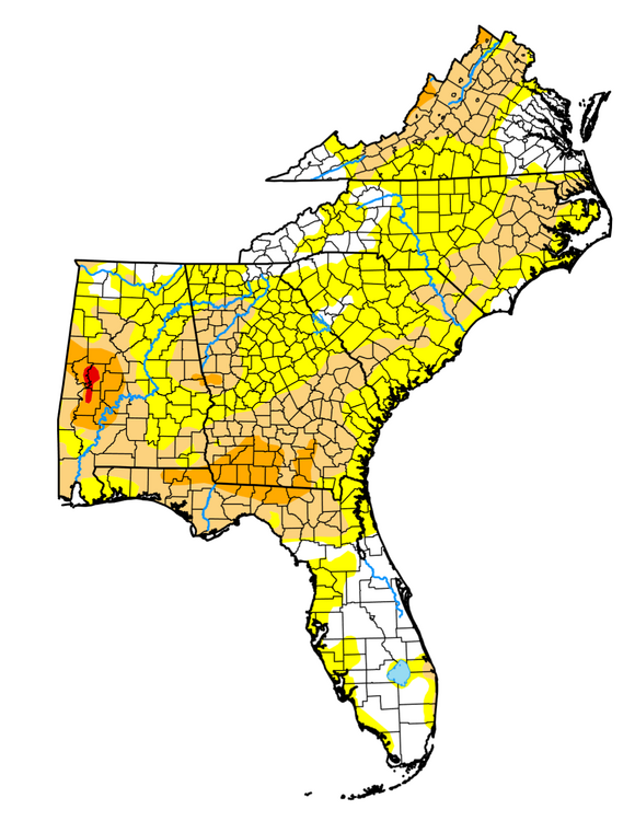
I know this sub-forum is mostly made up of North Carolina folk, but living in Tallahassee it's the closest I've got. We're currently under a severe drought after the 3rd driest September on record at TLH. Only ~0.5" of rain fell in September, which came at the end of the month on one day from one thunderstorm. There isn't any drenching rainfall expected in the next week or so, though scattered rainfall chances at least increase with a bit more southerly flow this weekend and early next week. Heading into our "dry" season, it could be an early start to the wildfire season as well. We might need a tropical system to really make a dent in the drought here across the Florida Panhandle, only at 10-20% of our normal rainfall in the past 30 days.
.thumb.png.8a97136344ec0b7deeb3e9a302ae6b3d.png)
-
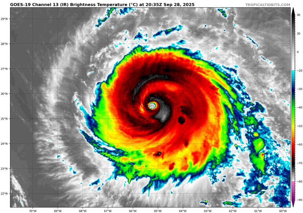
What an incredible beast
-
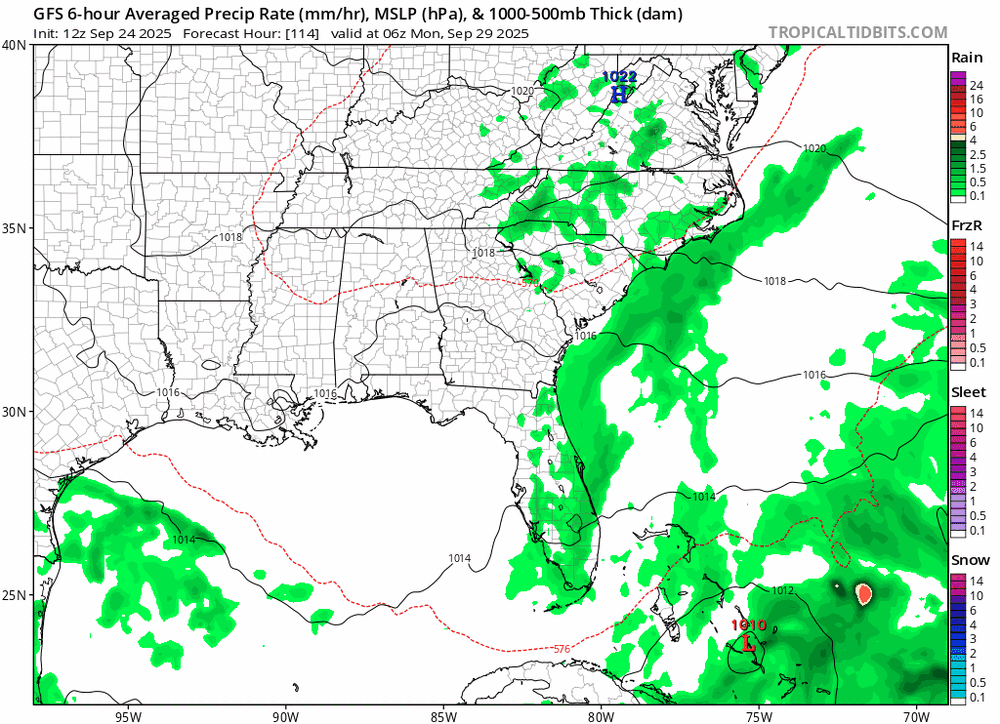
That 12Z GFS run definitely on the far western edge of the NHC cone and envelope, Florida East Coast most certainly gets in on outer rain bands in that scenario. TS Watches are up along coastal Martin to Volusia counties in East-Central Florida (Melbourne CWA)
-
0z hurricane models. More showing the stall and turn east motion now.
-
Agreed. I work at FDEM as one of the mets and we've been trying our best to communicate the uncertainty in the forecast at the 3-4 day range. But at this point, most people expect a solid "answer". Not expecting any direct impacts from Imelda here, but are keeping our Florida East Coast partners well informed. On another note, South Carolina has just declared a state of emergency
-
Should have PTC 9 at the 5pm or 8pm advisory at the latest, it's coming up on Tomer Burg's site as a PTC now. By the way, some really nice value added products on his tropics site: polarwx.com/tropical
-
The trend in the forward motion of 94L is perhaps one of the biggest changes in the past day or so. The GFS went from having it buried in the Bahamas late Sunday/early Monday to being 12 hours away from a Carolinas landfall at that same time. This has certainly helped with the questions regarding interactions between 94L and Humberto. Such a faster 94L eliminates really any fujiwhara conversations. But, we are still within the 4-5 day range where I wouldn't take much off the table yet, other than perhaps a northern Mid-Atlantic and New England hit with such strong confluence present up there
-
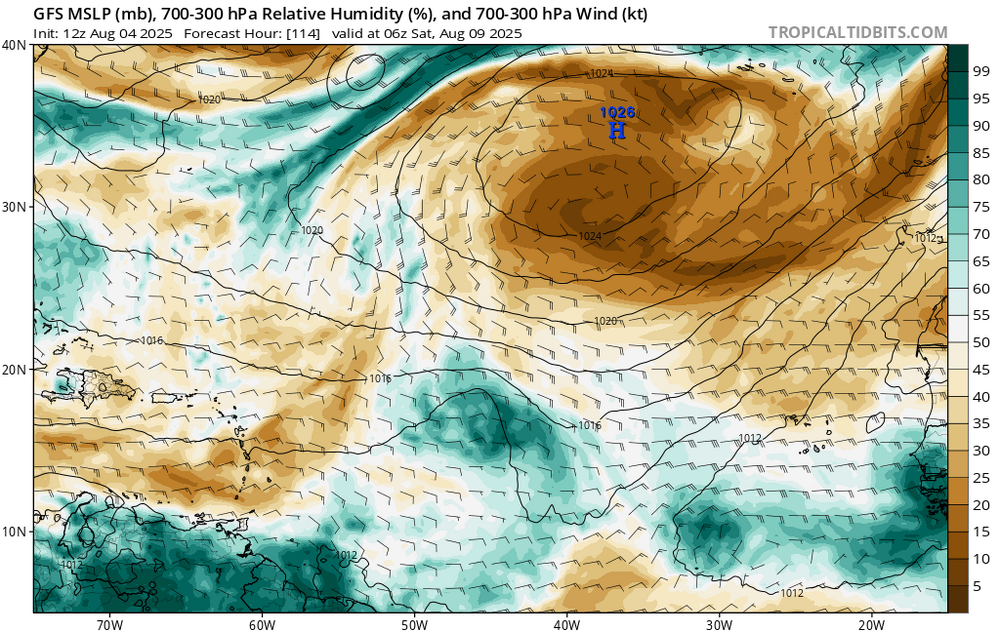
The trend in the recent GFS and Euro runs has clearly been towards a stronger HP system over the top of Humberto, which effectively allows it to strengthen faster, move slower, and travel more on a west-northwest heading vs purely northwest. This allows for greater spacing between 94L and Humberto, it "escapes" out ahead of Humberto without any real fujiwhara or interactions. Humberto plays a big role in the final evolution of 94L. How quickly 94L can develop once crossed over Hispaniola also is huge, but we don't know that yet. Until a well-defined center of circulation and system is there, there's lots of uncertainties
-
In most cases I wouldn't even think twice about the Euro AI showing a system developing in the Western Carribean at Day 11, but it is interesting to note that both the Google Deep Mind GenCast and regular Google Deep Mind ensemble are highlighting TC genesis in the same location and time, and then tracking into the Gulf. What are the AI models picking up on (or not) that the physics-based deterministic aren't? And to note, even the NHC is using the Google DM in their official forecasts. It has done very well this season.
-
Quite the bust with this wave. The Euro AI did well on not biting on this one
-
E PA/NJ/DE Autumn 2025 Obs/Discussion
Newman replied to PhiEaglesfan712's topic in Philadelphia Region
A couple climate statistics for Allentown as we wrapped up August: The average temperature was 70.0F, the coolest August since 2008. Likewise the average minimum was 58.3F, the lowest since 2008. The lowest minimum recorded was 45F, which is the lowest August min since 2000 (which tied with a min of 45). The next year that recorded a lower minimum in August is 1986! 1.6" of precip fell, which is the driest August since 2008. -
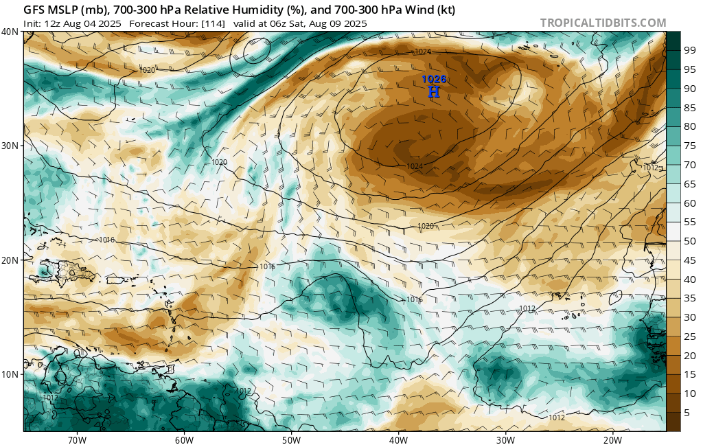
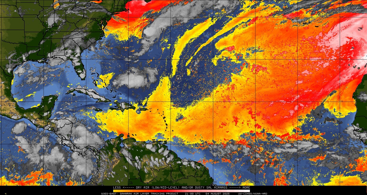
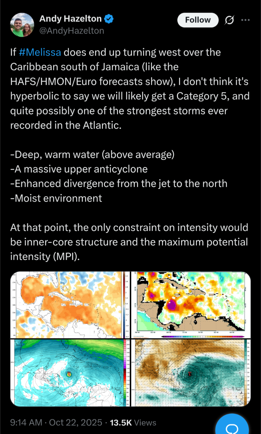
Echoing what Andy said on twitter here, this has been my thinking with any tropical system development in the MDR this month: https://x.com/AndyHazelton/status/1952439813619003854 We've had round after round of SAL outbreaks across the Atlantic the past month or two. It looks to relax a bit in this favorable stretch approaching, but I won't believe any model until we see a potent AEW with persistent convection. Also, beyond just a wave developing into a TC, I think the real key in the modeling is how they handle the weak ULL in the north Atlantic and if that allows for a weakness for a TC to slip north. Current SAL situation: 12z GFS with the tropical wave and some lessening of the dry upper air regime.


.png.9b2115fe4ff30ab0ce13cb9ed02f3918.png)

.png.11813b2b930a4b2f77967ff7ce56d9af.png)