Newman
-
Posts
2,500 -
Joined
-
Last visited
Content Type
Profiles
Blogs
Forums
American Weather
Media Demo
Store
Gallery
Everything posted by Newman
-
100%. Let's just keep it here and snag an upper echelon MECS board wide.
-
The 6z Euro backed off just a tad with how far the primary drives north which kept the mid-level warmth south of Philly for now and also keeps the dry slot a bit more muted as the low transfers to the coast
-
Just got the chance to look at the 0z suite... Wow, there's your north trend and then some. Now that it seems increasingly possible you aim the intense WAA snows over the region, the entire evolution and storm is a bit different. I know the global models are showing a solid 18-24 hour storm, but from experience you usually only get 12-15 hours at most from a WAA thump until you dry slot. If I were to be super picky and extra HECS hunter, that would be what I'm not a fan of. But hey, if the Euro is right and you throw 1.25" QPF into an air mass with surface temps in the upper single digits and lower teens, as well with localized 700 fgen, easily crank out a few hours of 2-3+ in/hr rates. Also, this could be an overreaction from the models with the shift north, we'll just have to see. But I do think if you want a true long duration event, you want to play the balance between getting into the WAA snows and the backside ULL/coastal that develops as the storm departs.
-
Y'all, just remember how these storms go. You will continue to see waffling of models for the next 4 days, but we're definitely reaching an inflection point where we raise the ceiling significantly for SE PA. EPS looks great, another huge tick north
-
GEFS another tick north, 0.6" QPF up to southern Berks and Lehigh. 0.7" into Philly.
-
EPS also bumped up quite a bit from what I saw. Widespread 6-8" across SE PA at 10:1. Ratios get you 8-12". I think most would sign up for that
-
Ukmet is a huge hit!
-

E PA/NJ/DE Winter 2025-26 Obs/Discussion
Newman replied to LVblizzard's topic in Philadelphia Region
DGZ is -12C to -17C. For many across SE PA, the entire atmospheric column is between this up to like 600 or 500mb. Even down to the surface in many places. If you throw some strong omega into the mix, poor snow growth would be the least of my worries. You're right though, if things were colder than -17C then we'd be looking at less stellar dendrites -
E PA/NJ/DE Winter 2025-26 Obs/Discussion
Newman replied to LVblizzard's topic in Philadelphia Region
6z GFS Op and GEFS came north again, AIGFS is a southern outlier for now. With a potential phase that models seem to be heading towards, I think a southern slider solution becomes much less likely -
E PA/NJ/DE Winter 2025-26 Obs/Discussion
Newman replied to LVblizzard's topic in Philadelphia Region
Are you thinking about chasing this one or gonna stick it out in Philly? I guess it depends on where we end up with this in a few days... -
E PA/NJ/DE Winter 2025-26 Obs/Discussion
Newman replied to LVblizzard's topic in Philadelphia Region
Yep, the 6z Euro AIFS also came back north and heading in that direction. We'll see if it's real at 12z -
E PA/NJ/DE Winter 2025-26 Obs/Discussion
Newman replied to LVblizzard's topic in Philadelphia Region
I'm pretty sure the Euro is going for an overrunning to coastal scenario. Looks like a completely different look now with a closed trough over the central Plains. Full phase -
E PA/NJ/DE Winter 2025-26 Obs/Discussion
Newman replied to LVblizzard's topic in Philadelphia Region
Absolutely, this will be a frigid storm. Just wait until we get into range for our CAMs that can handle banding. -
E PA/NJ/DE Winter 2025-26 Obs/Discussion
Newman replied to LVblizzard's topic in Philadelphia Region
Ukie another big hit. A bit less amped from the insane 12z run, but still gets 1" QPF to Berks and Lehigh. -
E PA/NJ/DE Winter 2025-26 Obs/Discussion
Newman replied to LVblizzard's topic in Philadelphia Region
Although I wouldn't go too crazy with ratios, seeing super deep DGZs like this could easily net you a 15:1 average ratio through the storm. Some places would exceed 20:1 within banding. -
E PA/NJ/DE Winter 2025-26 Obs/Discussion
Newman replied to LVblizzard's topic in Philadelphia Region
1" QPF line right along I-95 south on the CMC 0.8-0.9" throughout SE PA. 9° in ABE at the peak of the storm, 13° verbatim in Philly. -
E PA/NJ/DE Winter 2025-26 Obs/Discussion
Newman replied to LVblizzard's topic in Philadelphia Region
There's the north jump on the GFS and the CMC about to lay down the hammer. -
E PA/NJ/DE Winter 2025-26 Obs/Discussion
Newman replied to LVblizzard's topic in Philadelphia Region
Oof, +60Bz is absolutely insane and cruel. Probably one of the strongest CME impacts in decades and the Bz is positive instead of negative. Would've been a modern day Carrington if that came in negative -
E PA/NJ/DE Winter 2025-26 Obs/Discussion
Newman replied to LVblizzard's topic in Philadelphia Region
So obviously I don't live in SE PA anymore, I've got a comfortable met job in Florida. But these MECS/HECS are just so fun to track and a great way to keep my meteorology skills sharp. My met job down here in Florida is so focused on tropical weather, except this past weekend with the snow haha. Man I was getting so bored of sea breeze convection all summer. When I lived in Berks throughout the 2010s and early 2020s, I think I forgot how rare storms north of 15-18" really are. For Philly, anything above 17" gets you into the top 10 of all time. And it has only snowed 2 feet there twice in recorded history. For ABE, a 20" storm puts you into the top 7 of all time. Of course, the past few years have been rough for big ones and I think it should make this even sweeter (if it does happen, no guarantees yet). We got so used to these MECS during past decades that, personally, I lost sight of how rare and treasured they really are. Remember, places like KPHL go back to the late 1800s and early 1900s sometimes with record keeping. So when you see these model outputs throwing around 1-1.5" of QPF into a cold dome with surface temps in the lower teens, you're immediately talking about something that has only happened maybe a handful of times in like 100 years. That in and of itself makes me appreciate just tracking the opportunity for something like that. -
E PA/NJ/DE Winter 2025-26 Obs/Discussion
Newman replied to LVblizzard's topic in Philadelphia Region
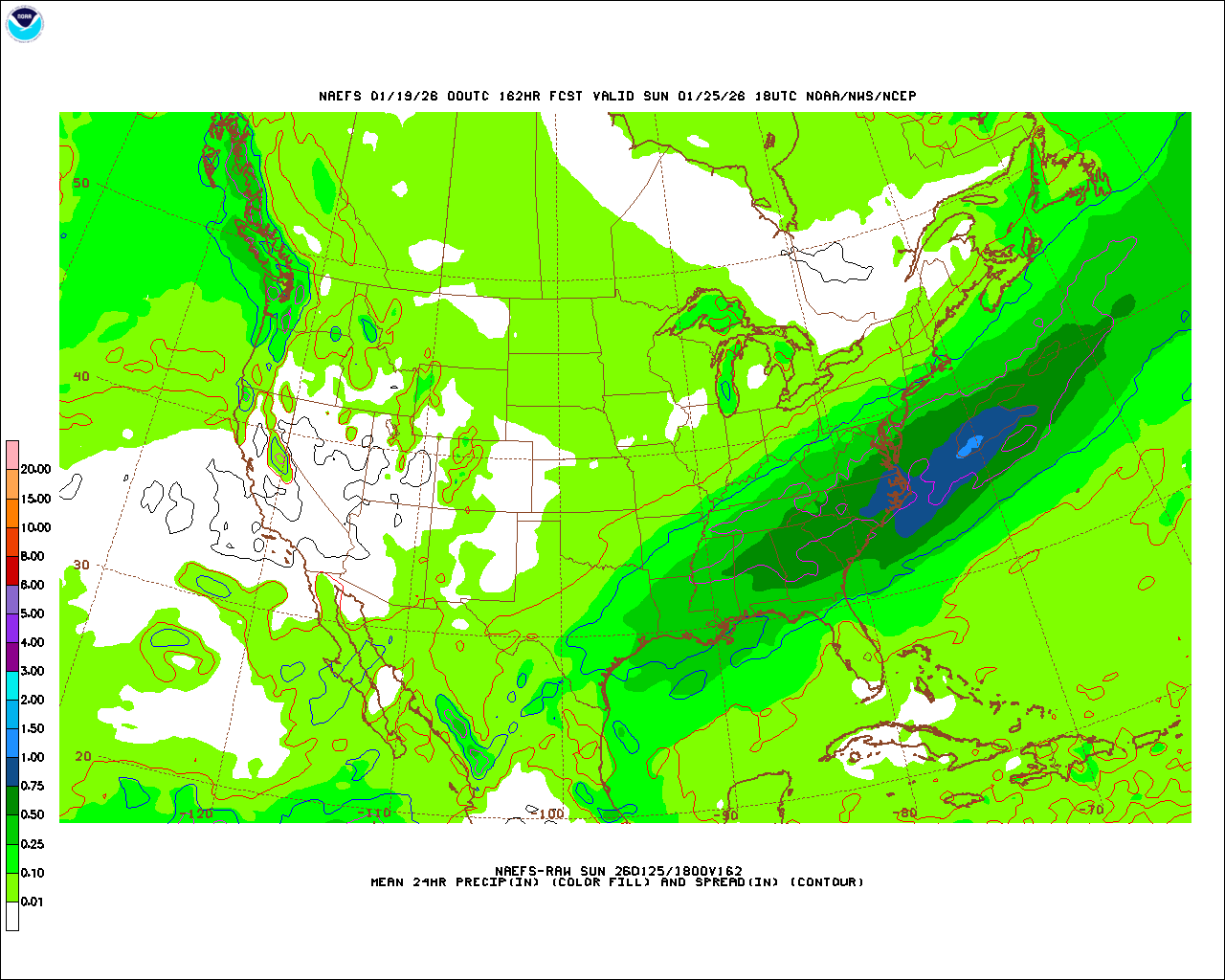
This was a great shift north on the NAEFS from 0z to 12z. I've found that the NAEFS are just as useful as some of our other ensembles because they take the CMC and GFS guidance combined. It's sorta like a North American specific grand ensemble. Just SE of I-95/Philly jumped from 0.25 to 0.5" of QPF. 0.25" extends well up towards I-80 now. Obviously jumping ahead a bit here, but for those who end up on the northern side of the precip shield and aren't smoking cirrus, you'll usually have a solid 700mb fronto band set up and can eek out additional inches that way.
-
E PA/NJ/DE Winter 2025-26 Obs/Discussion
Newman replied to LVblizzard's topic in Philadelphia Region
If we take into account *probable* ratios, the Euro now has 6-8" extending up to Berks and Lehigh. And I don't think this is done shifting north. Even as is, I think most south of I-78 would take and roll the dice for a different jack with the next storm systems -
E PA/NJ/DE Winter 2025-26 Obs/Discussion
Newman replied to LVblizzard's topic in Philadelphia Region
Ukie is a great hit -
E PA/NJ/DE Winter 2025-26 Obs/Discussion
Newman replied to LVblizzard's topic in Philadelphia Region
Absolutely, the 28-29th seems like a great coastal storm threat as well. There will be plenty of chances -
E PA/NJ/DE Winter 2025-26 Obs/Discussion
Newman replied to LVblizzard's topic in Philadelphia Region
If the CMC is even close to right and we get that energy to eject and phase, then holy shit -
E PA/NJ/DE Winter 2025-26 Obs/Discussion
Newman replied to LVblizzard's topic in Philadelphia Region
Best case scenario is something like what we saw with the fantasy GFS run a few days ago: the Baja California energy ejects very efficiently and runs into a brutally deep cold dome and we squeeze out a lot of moisture along the baroclinic zone. The worst case scenario (and the most likely fail mode) is the energy gets held back and or doesn't eject efficiently and it's a congrats Richmond. And also if the HP keeps trending stronger. But until then, I see absolutely no reason to worry about rain in this set up. If the 6z AI GFS happened, then sure you might flip to sleet. We will have to see wholesale changes with the Arctic high to worry about rain