Jump to content

NJwx85

Members
  • Posts

    19,256
  • Joined

  • Last visited

Everything posted by NJwx85

  1. If the rain later today and tonight underperforms some areas in the interior might not even get much of anything.
  2. The 06z GFS wasn't a terrible look however the shortwave I have circled needs to go away. It's suppressing the heights to our East. If it not for that, it's a classic setup for a big storm.
  3. The storm doesn't really mature until it's mostly past this area. The CCB develops late, just in time for it to wallop Central and Northern New England. Even the 06z GFS has jumped ship for our area and now has the more suppressed solution. Someone in New Hampshire is going to get well over a foot of snow.
  4. On a side note, this is my favorite type of storm. Overrunning well out ahead comes in Friday late afternoon. Then storm really cranks overnight into Saturday morning as low tracks from ACY to Cape Cod. Would be a perfect track for a crippling, long duration blizzard if the Northern piece was able to get out ahead a tad more. 12z GFS has 6"+ for Springfield and NW CT. We're not missing this by much.
  5. It's been cold around here since the big thaw last weekend. Had a hard frost this morning. Ground certainly isn't frozen but with low sun angle and it being December it should accumulate away from the coast if it comes down even moderately. North shore of LI looks good too.
  6. Typical windshield washer back and forth at this stage. 00z models tonight will be telling.
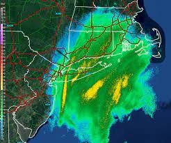
  7. Nice deformation band signal on the 3k NAM. Temperatures for interior NJ and Southeast NY look to be in the mid-30's but the rest of the column is cool so we could see a changeover to a heavy wet snow inland on Saturday morning.
  8. What a beast on the GFS. Over 3” of rain in many spots.
  9. Severe Weather Statement National Weather Service Mount Holly NJ 359 PM EST Mon Nov 30 2020 NJC011-033-302115- /O.CON.KPHI.TO.W.0035.000000T0000Z-201130T2115Z/ Cumberland NJ-Salem NJ- 359 PM EST Mon Nov 30 2020 ...A TORNADO WARNING REMAINS IN EFFECT UNTIL 415 PM EST FOR NORTHWESTERN CUMBERLAND AND SOUTH CENTRAL SALEM COUNTIES... At 359 PM EST, a severe thunderstorm capable of producing a tornado was located over Newport Meadows, or 10 miles west of Bridgeton, moving northeast at 35 mph. HAZARD...Tornado. SOURCE...Radar indicated rotation. IMPACT...Flying debris will be dangerous to those caught without shelter. Mobile homes will be damaged or destroyed. Damage to roofs, windows, and vehicles will occur. Tree damage is likely. Locations impacted include... Alloway, Shiloh and Newport Meadows. PRECAUTIONARY/PREPAREDNESS ACTIONS... Protecting yourself from immediate threats to life and safety shall take priority. Whenever possible, as long as it does not cause greater harm, all COVID-19 protective action guidance should be followed. TAKE COVER NOW! Move to a basement or an interior room on the lowest floor of a sturdy building. Avoid windows. If you are outdoors, in a mobile home, or in a vehicle, move to the closest substantial shelter and protect yourself from flying debris. && LAT...LON 3948 7543 3956 7535 3946 7524 3934 7542 3943 7549 TIME...MOT...LOC 2059Z 230DEG 32KT 3940 7541 TORNADO...RADAR INDICATED HAIL...<.75IN $$ Iovino Tornado Warning NJC019-PAC017-091-302130- /O.NEW.KPHI.TO.W.0036.201130T2053Z-201130T2130Z/ BULLETIN - EAS ACTIVATION REQUESTED Tornado Warning National Weather Service Mount Holly NJ 353 PM EST Mon Nov 30 2020 The National Weather Service in Mount Holly NJ has issued a * Tornado Warning for... South central Hunterdon County in northwestern New Jersey... Central Montgomery County in southeastern Pennsylvania... Central Bucks County in southeastern Pennsylvania... * Until 430 PM EST. * At 353 PM EST, a severe thunderstorm capable of producing a tornado was located over Lansdale, or 17 miles north of Philadelphia, moving northeast at 50 mph. HAZARD...Tornado. SOURCE...Radar indicated rotation. IMPACT...Flying debris will be dangerous to those caught without shelter. Mobile homes will be damaged or destroyed. Damage to roofs, windows, and vehicles will occur. Tree damage is likely. * Locations impacted include... Lansdale, Doylestown, Byram, Chalfont, Tinicum, New Hope, Pipersville, Gardenville, Lumberville, Lambertville, New Britain, Brittany Farms-Highlands and Montgomeryv
  10. Pretty much a non event so far out here in Rockland. Just some gusts to 25-30 besides the rain. We’ll see if the storms make it up here.
  11. Wilma seems like a decent analog although obviously it recurved further East than what Delta is going to do.
  12. zzzzz... Rain looks to be in and out in 6-8 hours. Most of the modeling has cut back to 1-2" with spotty 2"+ totals. I'm really hating that every event lately is in and out in under 8 hours. That doesn't bode well for Winter.
  13. Very low probability IMO that Teddy will be a big factor here. The trough South of Greenland this weekend should be enough to create a weakness in the ridge which allows the storm to escape. Obviously Bermuda will need to pay close attention. Somewhat bad timing so far during peak season with regards to East coast threats. Just remember that Sandy didn't occur until the very end of October so we have a long way to go.
  14. Flash Flood Warning needed here immediately. Heaviest rain here in years.
  15. I think models are underdone on the NW side. Dewpoints are in the mid 70's and the cold front is still back by the Canadian border.
  16. Sun is out here. Look how much SBCAPE is in place. I expect it to be an active afternoon.
×
×
  • Create New...