

NJwx85
-
Posts
19,685 -
Joined
-
Last visited
Content Type
Profiles
Blogs
Forums
American Weather
Media Demo
Store
Gallery
Everything posted by NJwx85
-
One of the main problems is that people don't listen to warnings but the biggest problem is that a majority of the public doesn't even understand what they mean or the difference between a watch and a warning. A large percentage doesn't understand the difference between straight line wind damage and a tornado either.
-
I still cannot get over the tornado in Gloucester County, NJ. Yes, we know that we can get tornadoes in NJ and NY but they are never this violent, this long tracked or as wide.
-
Indeed, runoff usually lasts 24 hours after rain stops so rivers won’t crest until tomorrow night.
-
The Ramapo and Pequannock meet in Pompton Lakes which then flows into Wanaque reservoir. When the dam opens it sends water downstream into Pompton Lakes. The Ramapo then flows into the Pompton River which floods Pequannock, Pompton Plains, Wayne and Lincoln Park. The Pompton ends at the Passaic River at two bridges road. It takes quite awhile for the Passaic to get all of the water. Two bridges is less than a mile from Williwbrook mall. If the Passaic gets high enough it will actually backflow into the Pompton.
-
It should be over by 1AM for most of us but what’s left is intensifying as it moves NE.
-
Numerous lightning strikes here and loud rolling thunder.
-
@Allsnow still going with an inch for NYC?
-
Tornado Watch TORNADO WATCH OUTLINE UPDATE FOR WT 484 NWS STORM PREDICTION CENTER NORMAN OK 620 PM EDT WED SEP 1 2021 TORNADO WATCH 484 IS IN EFFECT UNTIL 100 AM EDT FOR THE FOLLOWING LOCATIONS NJC003-013-017-031-039-020500- /O.NEW.KWNS.TO.A.0484.210901T2220Z-210902T0500Z/ NJ . NEW JERSEY COUNTIES INCLUDED ARE BERGEN ESSEX HUDSON PASSAIC UNION $$
- 511 replies
-
- 1
-

-
- heavy rain
- tropical gusts
- (and 1 more)
-
Tornado Watch TORNADO WATCH OUTLINE UPDATE FOR WT 484 NWS STORM PREDICTION CENTER NORMAN OK 620 PM EDT WED SEP 1 2021 TORNADO WATCH 484 IS IN EFFECT UNTIL 100 AM EDT FOR THE FOLLOWING LOCATIONS NYC005-047-059-061-081-085-087-103-119-020500- /O.NEW.KWNS.TO.A.0484.210901T2220Z-210902T0500Z/ NY . NEW YORK COUNTIES INCLUDED ARE BRONX KINGS NASSAU NEW YORK QUEENS RICHMOND ROCKLAND SUFFOLK WESTCHESTER $$
- 511 replies
-
- 1
-
-
- heavy rain
- tropical gusts
- (and 1 more)
-
Unloading here in Mahwah
-
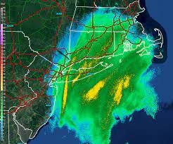
All you need to look at now is the radar to see what's coming.
- 511 replies
-
- 2
-
-
- heavy rain
- tropical gusts
- (and 1 more)
-
Location was near Edgewater, MD.
-
I remember the storm well. I was in high school.
-
That storm was child's play compared to this one...
- 511 replies
-
- 1
-
-
- heavy rain
- tropical gusts
- (and 1 more)
-
Too much model hugging and not even meteorology.
- 511 replies
-
- 3
-
-
- heavy rain
- tropical gusts
- (and 1 more)
-
Been on and off torrential rain here all day so far. Some areas will have seen 2-3" before the main show happens which will easily drop an additional 4-6" areawide.
-
Almost all of Southern PA is currently under a flash flood warning and the heaviest convection hasn't even fired yet.

