hlcater
-
Posts
2,686 -
Joined
-
Last visited
Content Type
Profiles
Blogs
Forums
American Weather
Media Demo
Store
Gallery
Everything posted by hlcater
-
lol that's hilarious.
-
Some rain would be nice
-
Had to work yesterday and missed all the tornadoes. Even better the forecast I had made was money and I would've seen the Jewell tornado.
-
This is looking pretty sauced up along residual OFB in IA.
-
Lol. We are aging well this hour
-
I’d lean bearish on near term intensity. Having such a fast forward motion and attendant strong fetch on the northern side is going to favor a very lopsided system even if shear and dry air are negligible. I suspect that the system will appear reminiscent of some of those later season gulf storms from recent years that suffer from the same issue, just rotated 90 degrees. Think the best shot for respectable intensification is after FH48 when this is in the eastern Caribbean and slowing down.
-

June 20th, 2021 Severe Weather Event
hlcater replied to HillsdaleMIWeather's topic in Lakes/Ohio Valley
I was originally gonna play the MCV in Illinois but it became evident early on that it was going to be a wash due to a westward propagating MCS in MO the night before. Due to this, I chose to target Marshalltown back on the cold front as I believed odds of destabilization and recovery were higher than on the MCV. I had forgotten my SD card for this chase, so all these are all high-quality iPhone captures.The first supercell went up and matured rather quickly near Ankeny. But seemed too early for the LLJ and didn't really do a whole lot while I was on it but it did feature high contrast and was quite photogenic at times as Ethan showed above. Despite this, I abandoned it at Searsboro for the storm that was quickly becoming dominant to the SW. Near Newton at 5:10pm. The first storm came closest to producing at this occlusion here at about 5:45 near Kellogg and it's a shame it lacked the extra kick it needed, because a tornado there would've been wickedly photogenic and I was in the perfect spot to view it. The 2nd storm was much more grungy and less photogenic, but never the less a little bit healthier than the first. Needless to say by this point the LLJ had begun to increase and sufficiently enlarge low level hodographs and this is really the only reason I can think of for why the first storm struggled to do much and the 2nd storm produced two tornadoes.This shot is looking at it as I arrived at 6:35pm Insert tornado #1 6:44pm and #2 at 7:03pm The storm threw out a huge gust front after this and never really recovered inflow dominance. So I called the chase in Oskaloosa and went to go shoot sunset pics. These are both unedited. The skies were really *that* saturated.- 236 replies
-
- 10
-

-
June 20th, 2021 Severe Weather Event
hlcater replied to HillsdaleMIWeather's topic in Lakes/Ohio Valley
welcome to the storm chasing community... -
June 20th, 2021 Severe Weather Event
hlcater replied to HillsdaleMIWeather's topic in Lakes/Ohio Valley
I still could. Debating it. I just worry that playing the MCV puts you out of position for storms in Iowa and you end up missing both. I think there's tornadoes from the MCV, but I also think Iowa has a shot to maybe do something better, along with some regional bias -
June 20th, 2021 Severe Weather Event
hlcater replied to HillsdaleMIWeather's topic in Lakes/Ohio Valley
Made the decision to forego the MCV in favor of the front in eastern Iowa. Let's see how well that ages.... -
June 20th, 2021 Severe Weather Event
hlcater replied to HillsdaleMIWeather's topic in Lakes/Ohio Valley
you thinking wind or tornadoes? If tornadoes, that's bold. I could see wind though. Storms moving out of Iowa later tomorrow evening should organize into a robust QLCS of sorts. -
At face value, I think the stuff back on the cold front probably ends up being a mixed mode conglomeration of giant hailers while the tornadoes are on the MCV.
-
I’m not sure that it does honestly. As a general rule yea I think you’d be right, but in this instance I’m not so sure. The MCV moves through at 18-20z depending on the model and almost certainly has a tornado threat associated with it. The issue comes with wake subsidence and the veering of the flow that happens behind it. Despite the late transit time, recovery back on the front in Iowa looks almost assured, yet the models that don’t have the MCV have far more backed low level flow than those that do. Seeing as there’s a 35-45kt LLJ in place already, I’m not sure how much help the MCV is actually giving, especially at the cost of veered flow on the primary boundary. Not to mention lapse rates are far steeper to the west than they are invof MCV.
-
An ill-timed MCV/MCS moving through the TA at 18z really does a number on the plume of steeper lapse rates sunday. Should provide a tornado threat in its own right but cant help but think this particular setup is actually better off without the MCV. Let the synoptics do the work.
-
Tomorrow looks to provide a solid opportunity for a real nice MCS across Iowa. Looking at potentially 5000+ MLCAPE, where spreads and mixing should favor cold pools and outflow dominance along with a 40kt LLJ. If it were me on desk, I'd have already introduced a 30% wind.
-
Think these pop ups are gonna be the best we’re gonna be able to do for the next 7-10 days....
-
Wonder how much D3/4 there is by August 31st...
-
It’s been pretty wet here over the past week, and unlike places further east, it appears that should continue to be the case over the next 7 days as well.
-
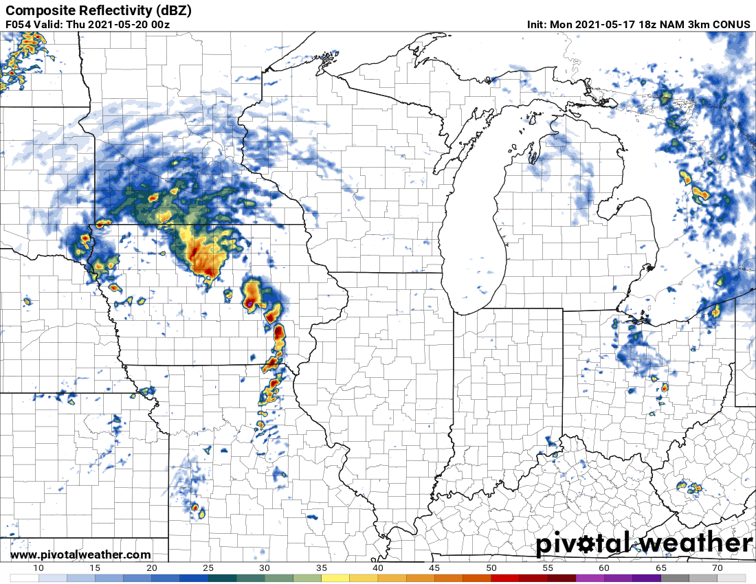
All in on the 3km NAM for this Midwest classic


-
This is honestly so pathetic
-
If RHs in the teens across much of northern Iowa isn’t a harbinger of drought, I don’t know what is.... Soil moisture must be totally abysmal with the lack of any appreciable precip recently. Things may be looking up with upcoming pattern change, or at least I hope so, because we’re gonna have some real problems if not.
-
-
Geez that storm is a monster. Nothing really stopping it from becoming a true long tracker either.
-
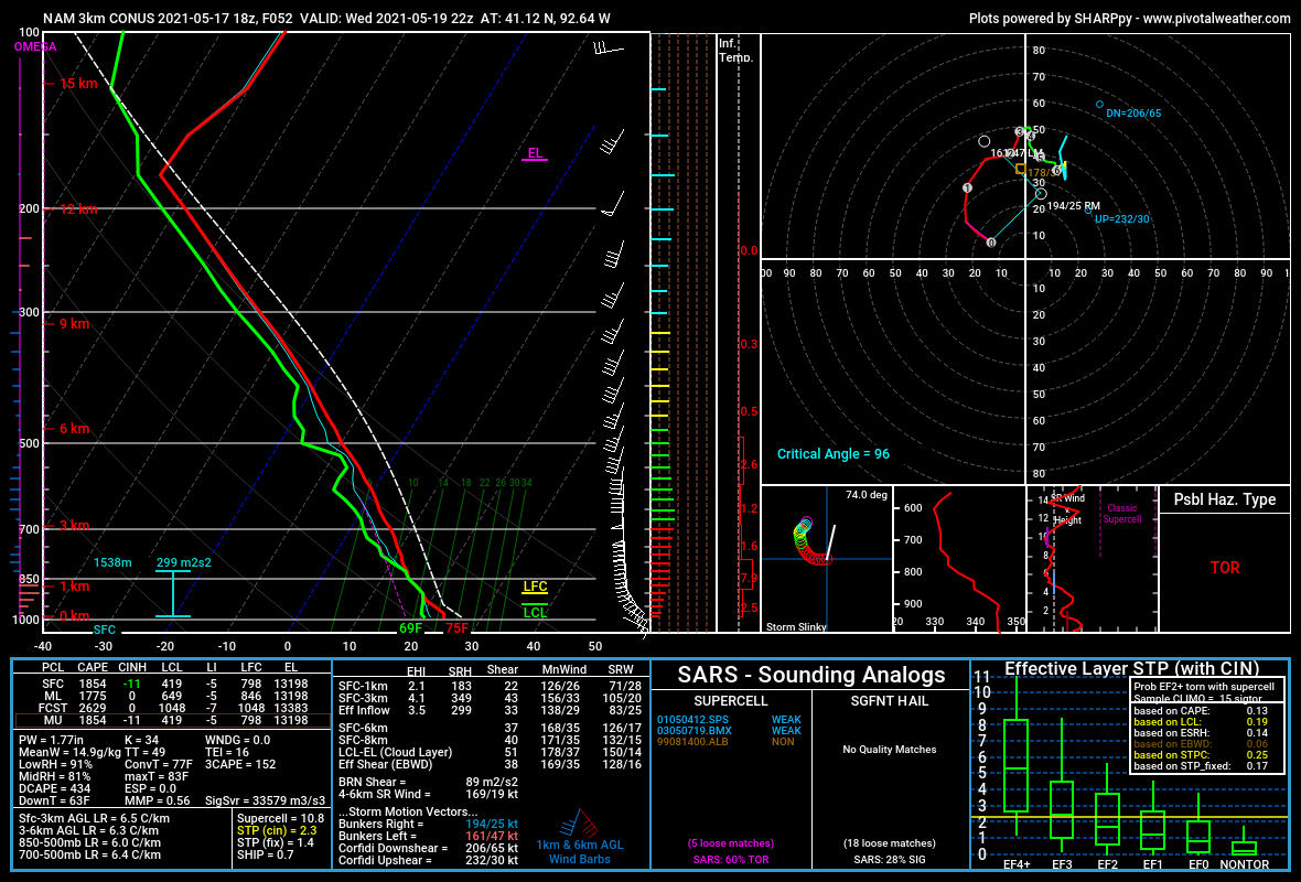
Normally you see forecast soundings like this localized along a warm front or at the triple point, but almost never do you see something like this taking shape over an entire region. Click anywhere from the KY/TN border down to I-20 and you're gonna get something that looks like this. These are the types of environments that produce violent tornadoes, and the spatial expanse of this type of environment tomorrow is nothing short of jaw dropping. Barring slowed warm front progression or storm mode concerns, I just don't see how we get away from this event unscathed. This is a totally different animal from last wednesday. Not even comparable. As such, if confidence increases, I wouldn't be surprised to see the high stretch in that area from the I-20 corridor to the KY/TN border.
-
No way this doesnt go high at 06z. Period.