sbnwx85
-
Posts
1,933 -
Joined
-
Last visited
Content Type
Profiles
Blogs
Forums
American Weather
Media Demo
Store
Gallery
Everything posted by sbnwx85
-
February rockin’ with 40’s and sun.
-
There’s been a band of moderate to heavy rain parked overhead for the last 3 or 4 hours. Too bad it’s not 10 degrees colder.
-
It’s raining again. My snowpack is gone. Ready for spring.
-

Winter 2023/24 Medium/Long Range Discussion
sbnwx85 replied to Chicago Storm's topic in Lakes/Ohio Valley
-
Gonna be a foggy couple nights, at least.
-
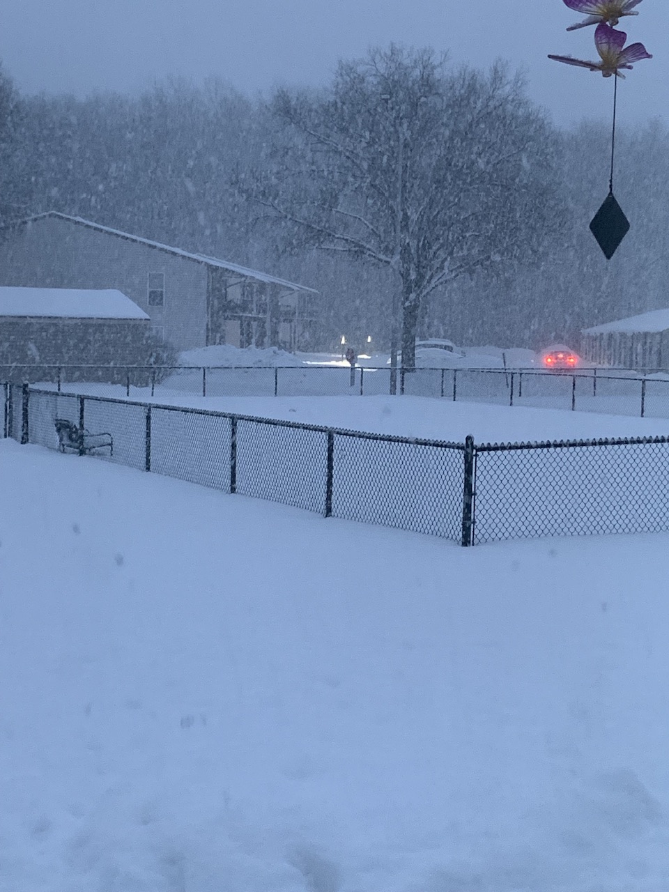
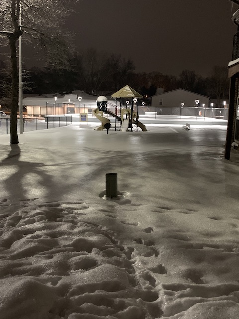
Looks like about a tenth of an inch of ice on ground level surfaces. Looks neat on the snow.
-
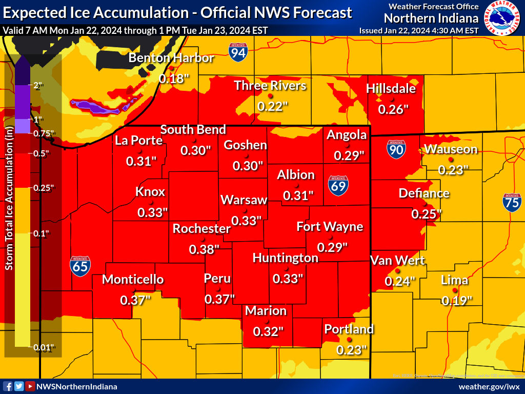
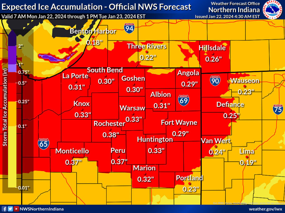
Looks like this will NOT be an Ice Storm Warning event. IWX AFD: Key messages: *Freezing rain tonight through Tuesday morning. Ice accumulations of 0.10 to 0.25 inch. *Treacherous travel Tuesday morning, before a transition to rain in the afternoon. Mapped ice accumulations have been reduced with the afternoon forecast package, as to not exceed 0.25". Please note that only a glaze of ice can cause significant travel issues. The messaging within the Winter Weather Advisory remains, "total ice accumulations of one tenth to a quarter of an inch.". An anticipated break in the precipitation, low wind speeds, and moderate rain rates will all work to limit FZRA accumulations much beyond 0.25". Furthermore, the lack of a blocking high pressure to our north and anticipated deep southerly flow will limit the risk of a significant ice storm. Regardless of the headline title, hazardous travel conditions are expected tonight through Tuesday morning. Air temperatures have warmed to near freezing this afternoon, with pockets of freezing rain being reported. Slippery travel conditions have been confined to the western and northwestern reached of the forecast area. This precipitation is the result of modest warm air advection ahead of a weak trough that has moved through the Great Lakes. The weak forcing, paired with our initial dry air mass, has limited precipitation rates thus far. However, light rainfall rates are very efficient with respect to ice accumulation; hence the slippery travel noted above. Amid southwest flow, freezing rain is expected to spread northeast through the forecast area tonight. There is high confidence that impacts to travel will become more common as the night goes on. This, as deeper moisture arrives and the thermal gradient aloft amplifies primarily toward and after midnight, bringing widespread freezing rain to the forecast area. The overnight timing and the preexisting cold temperatures continue to provide high confidence in accumulating ice tonight. Toward dawn, moderate rainfall rates will ease icing efficiency, followed by a gradual warming trend from south to north in the afternoon. A transition to all rain is expected Tuesday afternoon. Therefore,the Winter Weather Advisory end time remains at 1pm EST Tuesday. It is plausible the air temperature in the vicinity of Hillsdale, MI could linger below freezing a a touch beyond that; something to be monitored on Tuesday.
-
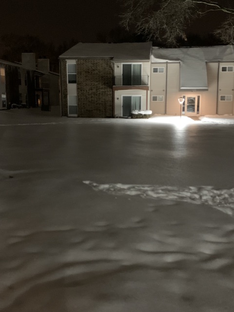
There's a light glaze on most surfaces. Untreated roads and sidewalks are very slick, but most people seem to have gotten the message and got the salt down.
-
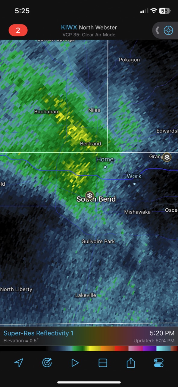
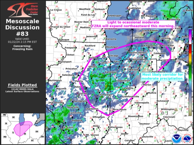
Mesoscale Discussion 0083 NWS Storm Prediction Center Norman OK 0917 AM CST Mon Jan 22 2024 Areas affected...portions of eastern/northeastern IL...northern IN...far southern MI and far northwest OH Concerning...Freezing rain Valid 221517Z - 221915Z SUMMARY...Light to moderate freezing rain is expected through the morning hours with rates of 0.01-0.03 in/hr possible. Some mixed-phase precipitation is also possible early. DISCUSSION...As of 15 UTC, regional radar mosaic imagery and surface observations showed a broad area of light to moderate wintry precipitation across parts of northeastern IL. Over the last hour, automated reports of unknown precipitation type and freezing rain have gradually become more numerous as the precipitation has expanded over an air mass with surface temperatures in the mid to upper 20s F. Driven primarily by low-level warm advection, light to moderate precipitation is expected to continue to move east/northeast this morning. Light snow has been observed across parts of southwest lower MI and northwest IN. However, observed and modified model soundings show an elevated warm nose of 1-2 C between 1-2 km AGL will gradually advect northeastward over the next few hours. While some snow and sleet are possible ahead of the main area of precipitation, gradually deepening of the elevated warm layer to near 600-800 m will favor a transition to predominately freezing rain. Rain rates of 0.01-0.03 in/hr are possible above favorable surface temperatures for rapid ice accretion. The most likely corridor for impactful freezing rain appears to be from northeastern IL into northwest IN and far southwest lower MI through this morning. Hi-res CAM guidance has been poor thus far in handling the evolution of the precipitation field. While low-level warm advection may wane slightly through the day, observed low and mid-level ascent appears strong enough to continue to support precipitation into the early afternoon. Given the cold surface temperatures and melting layer aloft, freezing rain appears likely. ..Lyons.. 01/22/2024 ...Please see www.spc.noaa.gov for graphic product...
-
Freezing drizzle already in South Bend. Advisory start time has been pushed up to noon.
-
Fascinating insight into your world as always @RCNYILWX thanks for sharing! I saw in the IWX media briefing there’s potential for wind gusts to 20 mph and that led me to believe there would be an increased risk of outages. But that appears to be in the early stages of this event before winds decrease.
-
LOT and IWX current forecasts are definitely Ice Storm Warning criteria. As long as mode trends hold I expect they pull the trigger around Noon on areas forecast to get more than 1/4” of ice.
-
IWX increased ice forecast a bit. Concerns about how quickly we get above freezing. LONG TERM...(Monday through Saturday) Issued at 337 AM EST Sun Jan 21 2024 Ahead of milder weather later this week, a wintry mix is still expected to develop Monday and persist until temperatures rise above freezing some time early Tuesday. Given the very cold conditions at the onset of the precipitation, surface/ground temperatures are likely to lag warming air temperatures for a few to several hours and allow extra time for ice to accumulate. Widespread model agreement prevails with temperatures rising above freezing over the entire area by noon. Thermal soundings are very limited with any snow (too warm aloft) and sleet (virtually no cold layer at the surface). Given the above, have increased ice accumulations from around 0.05" in the southeast (Lima) to around 0.20" west of Highway 31. Temperatures will stay much above normal through the rest of the week given a very strong positive anomaly (per CPC) over more of North America. CIPS analogs also show a 95% chance for temperatures to be above normal early next week.
-
For those interested in the snow aspect of the storm. NAM is probably showing its warm bias?
-
Seems like this will be more of a nuisance event, but will cause issues on the roads. A tenth of an inch seems like a good bet across areas that see ice. It will be interesting to see how long freezing temps hang on around the snowpack and could lead to a little more icing. I’m not posting the GDPS because it’s an outlier but it shows a much more significant icing event across Central Indiana and Illinois, sleet across I-80 and snow north of that.
-
Winter 2023/24 Medium/Long Range Discussion
sbnwx85 replied to Chicago Storm's topic in Lakes/Ohio Valley
February will be rockin’ (with thunderstorms) -
Did Someone Say Clipper(Hybrid)!?! 1/18-1/19
sbnwx85 replied to Frog Town's topic in Lakes/Ohio Valley
Just got in to the Chicago suburbs. Took the Toll Road in and hoo boy was that a slow go through LaPorte County. Even though I was focused on the road and it’s night, I can tell you it was the most snow I’ve ever seen on the ground. -
Did Someone Say Clipper(Hybrid)!?! 1/18-1/19
sbnwx85 replied to Frog Town's topic in Lakes/Ohio Valley
3.5” of LE today so far. Nearing a foot of snow depth. -
Did Someone Say Clipper(Hybrid)!?! 1/18-1/19
sbnwx85 replied to Frog Town's topic in Lakes/Ohio Valley
Snow confirmed.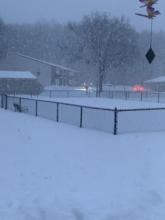
-
Did Someone Say Clipper(Hybrid)!?! 1/18-1/19
sbnwx85 replied to Frog Town's topic in Lakes/Ohio Valley
It’s about to snow it’s ass off.
-
Did Someone Say Clipper(Hybrid)!?! 1/18-1/19
sbnwx85 replied to Frog Town's topic in Lakes/Ohio Valley
Nothing yet. But the band is shifting slowly this way. Could end up with half a foot before it shifts back to the west. -
Did Someone Say Clipper(Hybrid)!?! 1/18-1/19
sbnwx85 replied to Frog Town's topic in Lakes/Ohio Valley
We’re getting some unofficial reports in our newsroom of 2 feet of snow in Michigan City. 19” in New Buffalo. -
Did Someone Say Clipper(Hybrid)!?! 1/18-1/19
sbnwx85 replied to Frog Town's topic in Lakes/Ohio Valley
Neat to see the lake effect band setting up as the system snow moves through. -
Did Someone Say Clipper(Hybrid)!?! 1/18-1/19
sbnwx85 replied to Frog Town's topic in Lakes/Ohio Valley
The HRRR scoots the lake effect band further toward South Bend Friday afternoon/evening before shifting back west. Would cut down on huge totals in any one location but "spread the wealth" over a slightly wider area. -
Did Someone Say Clipper(Hybrid)!?! 1/18-1/19
sbnwx85 replied to Frog Town's topic in Lakes/Ohio Valley
At this point thinking 1-2” from the system tonight. We’ll see how much the lake effect wobbles east. WSW calls for 4-8” in South Bend.