

sbnwx85
-
Posts
1,933 -
Joined
-
Last visited
Content Type
Profiles
Blogs
Forums
American Weather
Media Demo
Store
Gallery
Everything posted by sbnwx85
-
The science might say GFS but my heart says Euro.
-
#TeamEuro
-
It can never be easy, can it? And I have no room in this forum to complain because right now I’m looking at either 10” of snow or a ‘78 redux. But it would be nice if the models could have a consensus for more than six hours at a time.
-
Eyeballing about 2-2.5”. Rain mixing in now.
-
6z GFS has me down to a measly foot.
-
Euro coming in stronger. Basically in line with the GFS thru hour 96.
-
My snow stick only goes up to 24” so after that I’m not sure how to measure for you guys.
-
I'm all in. Bet the house, the car and the dogs on this one. Send me to the poor house if this one doesn't hit.
-
Another outrageous run. Trying to stay calm.
-
Going to wake up early to see my 3" of cement before it melts.
-
-
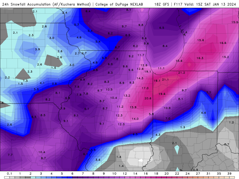
This is 24 hr storm totals for this storm on GFS valid 18z Saturday. Keep in mind it’s still snowing in Northern Indiana and Michigan so add at least a couple more inches there. Edit: Northern Indiana*
-
Agree. I think we’ve seen the extremes of how far east and west this thing can go in the Euro and GFS today. Hoping for a spread the wealth big dog in the Great Lakes which is still very much in the table.
-

Winter 2023/24 Medium/Long Range Discussion
sbnwx85 replied to Chicago Storm's topic in Lakes/Ohio Valley
That was one of the more interesting Euro runs. Somehow I still get like a foot of snow. -
As the track shifts NW I’m putting all my eggs into the basket of wave one. Could manage 3”-6” and hope the rain doesn’t melt all of it away. Would make for a slushy commute. Seems like the 2nd wave will be relatively minimal this far east.
-
Winter 2023/24 Medium/Long Range Discussion
sbnwx85 replied to Chicago Storm's topic in Lakes/Ohio Valley
Lol we all stopped posting in the Tuesday storm thread to come here. -
Winter 2023/24 Medium/Long Range Discussion
sbnwx85 replied to Chicago Storm's topic in Lakes/Ohio Valley
I can’t remember the last time I’ve seen the GFS max out snow totals in the Midwest like that. -
Winter 2023/24 Medium/Long Range Discussion
sbnwx85 replied to Chicago Storm's topic in Lakes/Ohio Valley
We are rockin', fellas! -
3.5" by Tuesday morning... completely melting by Tuesday evening followed by 2.2".
-
We'll reel in the one next Friday
-
Should have just made this my final call two days ago.
-
Went from the northern edge of the best snows at 12z GFS to nearly being all rain on the 18z GFS. Split the difference, right?
-
I told myself I was going to wait until Friday but I can't stay away.
-
Models are starting to get that look to them here, too. I'm far from making a final call, but I'm more than prepared for a front end inch of slop, followed by rain, followed by a couple inches of wind-whipped lake effect/enhancement. Active pattern behind this system, though.
-
Raw, damp day today. Getting light rain, snow and sleet.


