sbnwx85
-
Posts
1,933 -
Joined
-
Last visited
Content Type
Profiles
Blogs
Forums
American Weather
Media Demo
Store
Gallery
Everything posted by sbnwx85
-

2024 Short/Medium Range Severe Weather Discussion
sbnwx85 replied to Chicago Storm's topic in Lakes/Ohio Valley
Radar losing that look though. -
2024 Short/Medium Range Severe Weather Discussion
sbnwx85 replied to Chicago Storm's topic in Lakes/Ohio Valley
Tornado Warning in South Bend. Has that feel. -
2024 Short/Medium Range Severe Weather Discussion
sbnwx85 replied to Chicago Storm's topic in Lakes/Ohio Valley
CBS2 says likely tornado near OHare, one confirmed near Frankfort. Absolutely wild. Perhaps 10 tornadoes at the same time. Blanket warning was the right call. -
2024 Short/Medium Range Severe Weather Discussion
sbnwx85 replied to Chicago Storm's topic in Lakes/Ohio Valley
Getting lots of lightning from the warm front (?) swinging through ahead of the main line. -
2024 Short/Medium Range Severe Weather Discussion
sbnwx85 replied to Chicago Storm's topic in Lakes/Ohio Valley
They just said yall get TOR Warnings. -
2024 Short/Medium Range Severe Weather Discussion
sbnwx85 replied to Chicago Storm's topic in Lakes/Ohio Valley
Wa wa wee wa! -
2024 Short/Medium Range Severe Weather Discussion
sbnwx85 replied to Chicago Storm's topic in Lakes/Ohio Valley
Feeling better about tonight's potential out here. I'll plan to stay awake for it. -
2024 Short/Medium Range Severe Weather Discussion
sbnwx85 replied to Chicago Storm's topic in Lakes/Ohio Valley
I slept through most of last night’s storms. I woke up to some rumbles, looked at radar and the line was decaying. I guess I didn’t miss much. -
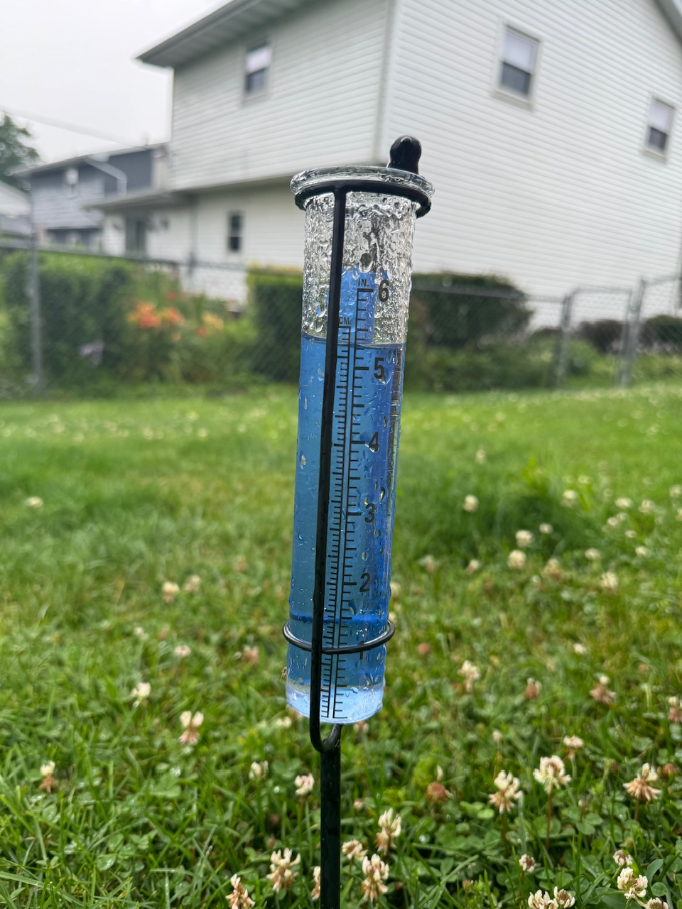
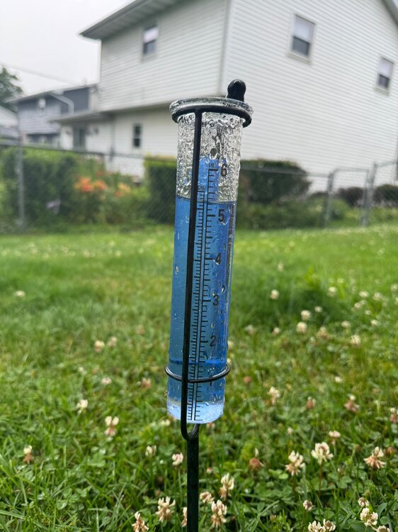
Added 0.90” of rain last night. 24-hour total at 2.67”.
-
2024 Short/Medium Range Severe Weather Discussion
sbnwx85 replied to Chicago Storm's topic in Lakes/Ohio Valley
Law enforcement reported funnel cloud in Elburn. Coming right into Geneva now. -
2024 Short/Medium Range Severe Weather Discussion
sbnwx85 replied to Chicago Storm's topic in Lakes/Ohio Valley
Hoping the line holds together enough to pack a decent punch this far east. It’ll be a close call. Should still get some thunder and heavy rain. -
2024 Short/Medium Range Severe Weather Discussion
sbnwx85 replied to Chicago Storm's topic in Lakes/Ohio Valley
The big one, two punch beginning soon. Mesoscale Discussion 1615 NWS Storm Prediction Center Norman OK 0315 PM CDT Sun Jul 14 2024 Areas affected...Parts of IA...northern IL...southern WI Concerning...Severe potential...Watch likely Valid 142015Z - 142145Z Probability of Watch Issuance...80 percent SUMMARY...Strong to severe storm development is expected later this afternoon into the evening. Eventual watch issuance is likely. DISCUSSION...Rather strong heating/destabilization is underway across much of IA this afternoon, while recovery in the wake of morning convection/outflow is ongoing across northern IL. Meanwhile, the remnant MCV from last night's severe MCS over the Dakotas is currently moving across northern IA. As MLCINH continues to erode across northern/eastern IA and MLCAPE increases above 3000 J/kg, the MCV may aid in scattered thunderstorm development later this afternoon. Midlevel flow is not particularly strong across the region, but sufficient to support effective shear of 25-35 kt and potential for some storm organization. Initial discrete development could evolve into a supercell or two, with a threat of hail, locally damaging wind, and possibly a tornado. In conjunction with the MCV, a persistent 20-30 kt southwesterly low-level jet could encourage relatively quick clustering and upscale growth, with some potential for an MCS to develop and move eastward across northern IL and southern WI this evening, with a continued severe-wind threat. Farther northwest, in the wake of the MCV, cumulus is deepening along a weak surface boundary across northwest IA. While this area is in the immediate wake of the MCV, strong buoyancy and sufficient deep-layer shear would support severe-thunderstorm potential in this area as well, if storms can mature. While favored timing and area remain somewhat uncertain, watch issuance will become increasingly likely if storm initiation appears imminent across the region. ..Dean/Hart.. 07/14/2024 ...Please see www.spc.noaa.gov for graphic product... -
Round 2 dropped 0.52” of rain. 1.77” on the day. Doubt we beat Beryl but a good soaking again nevertheless.
-
Trying to pull off the rare three-storm day. Got 1.25” from overnight boomers. Hoping this round clips me in the next half hour. Then all eyes on the late night round.
-
2024 Short/Medium Range Severe Weather Discussion
sbnwx85 replied to Chicago Storm's topic in Lakes/Ohio Valley
Tomorrow evening has potential for a big windbag across Northern Illinois and Northern Indiana. -
Storm total will end at 5.75”. Sun is starting to come out now.
-
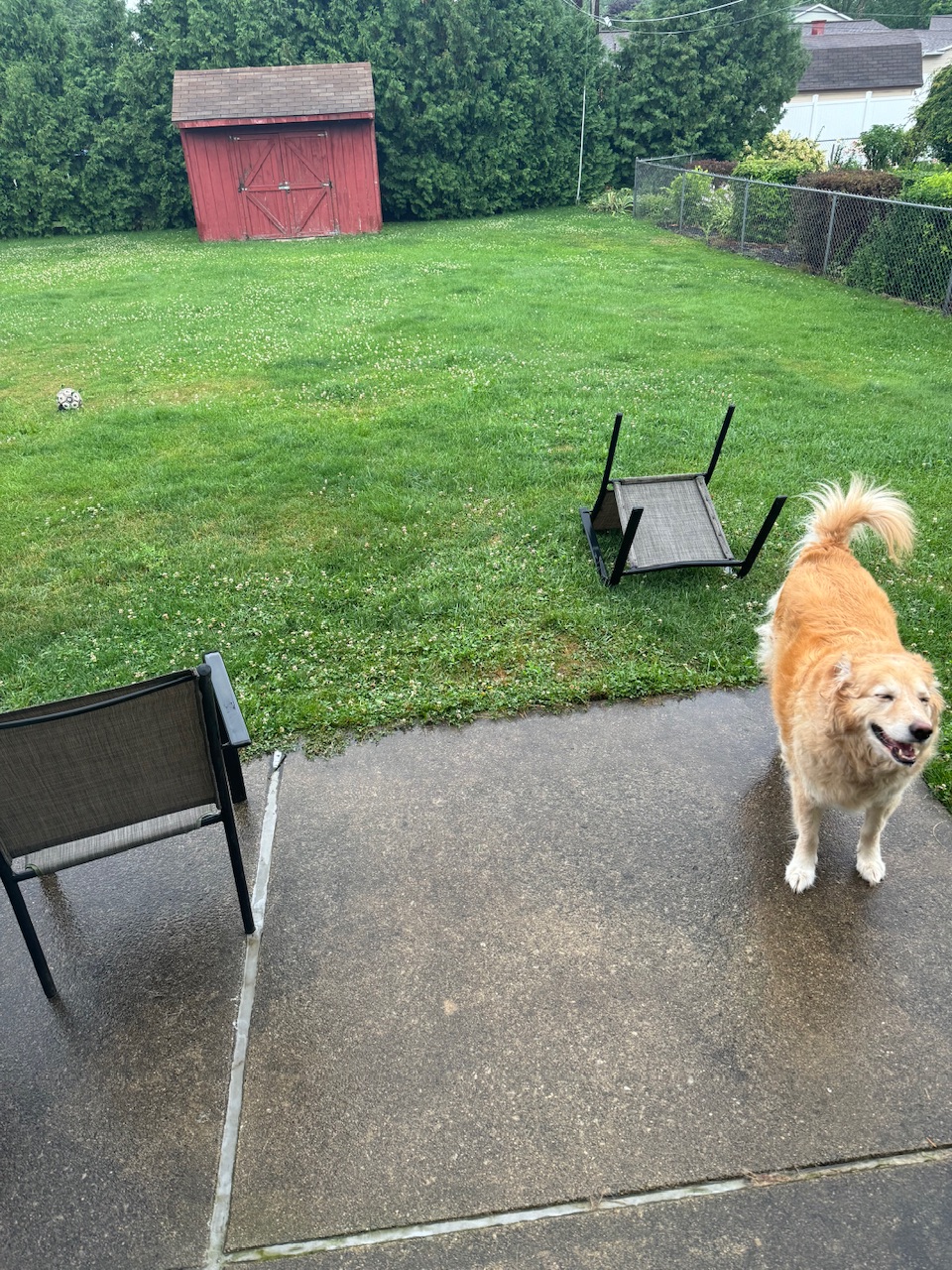
Up to 5.25” with a heavy band of rain still meandering about. The winds have been gusty at times. A little “wind damage” when the lawn chair blew over but Robyn says she’s confident we will rebuild.

-
Rain totals have been held in check IMBY so far. Only about 1/3”. Some isolated areas are over 4” though and are already under Flood Warnings. Heavier rain is just starting. The low should deepen overnight bringing heavier rain and decent wind gusts into the morning. Might be the closest I get to a tropical cyclone in my life
-
Some areas already with 3+ inches of rain in southern Michigan.
-
Perfect track wasted on 4” of rain! We kind need it though. Edit to add the winds on the backside may produce some tropical storm conditions for a few hours here so that could be fun.
-
If the mets at IWX are brave they'll issue Tropical Storm Warnings.
-
12z NAM says "take the kayak to work" for some.
-
Good afd write up from IWX this afternoon. Tuesday through Thursday looks to be the primary period of concern for this forecast valid period as remnants of Beryl may impact the western Great Lakes and/or Ohio Valley. A rather complicated synoptic pattern makes predictability on the low side regarding finer details with exact track. An upper low in northwest upper flow is expected to eventually merge with remnants of Beryl later Tuesday with this consolidated upper level trough lifting northeast across the southern Great Lakes on Wednesday. The exact track/strength of the low/mid level height minimum remains of low confidence as initial warm core/latent heat dependent nature of this system is hard to pin down at this forecast distance. Ensemble spread appears to increase sharply with track of low level features after 00Z Wednesday. Scattered showers and storms may fill in during the day Tuesday well north of low center as low/mid level fgen axis extends north into southern Great Lakes. While details will need to be refined, the possibility of at least portions of the area getting into heavy rainfall Tuesday night/Wednesday still appears intact as PWATS may increase to 2+ inches late Tuesday/Wednesday. Antecedent conditions have been on the dry side most locations which could alleviate some of the concerns, but if higher end rainfall amounts in excess of 3 or 4 inches are realized in deformation forcing zone, some hydro issues are possible. Have issued an ESF this afternoon highlighting the late Tuesday-Wednesday evening period for some heavy rainfall potential. Possible northward advection of mid level dry slot midweek could sharpen up the axis of heaviest rain to a greater degree than current guidance indicates. If a slower/westward trend ends up verifying, there is some low possibility that a marginal severe risk could evolve in a brief window across the far southeast during this period.
-
Looking rough.
-
If this ends up being a dud I’ll know not to start any new storm threads this winter. Models are now constantly showing the remnants of Beryl will impact parts of our forum with at least a heavy rain threat. May also be a marginal severe threat south/east of the low. GFS: EURO: WPC excessive rainfall Day 3: Day 4: