StormchaserChuck!
-
Posts
2,274 -
Joined
-
Last visited
Content Type
Profiles
Blogs
Forums
American Weather
Media Demo
Store
Gallery
Everything posted by StormchaserChuck!
-

Snowiest place on earth
StormchaserChuck! replied to LongBeachSurfFreak's topic in Weather Forecasting and Discussion
A few years ago, it was breaking 127/128F in Death Valley for 4 days in a row in early June. All-time record is 134. With SW High getting stronger, something to watch out for. -
2021-2022 ENSO
StormchaserChuck! replied to StormchaserChuck!'s topic in Weather Forecasting and Discussion
The La Nina-state is not breaking here. Subsurface: -PDO Even when the NW Pacific ridge breaks, it's -PDO.
-
2021-2022 ENSO
StormchaserChuck! replied to StormchaserChuck!'s topic in Weather Forecasting and Discussion
Now we have an El Nino pattern setting up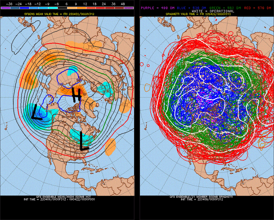
-
Snowiest place on earth
StormchaserChuck! replied to LongBeachSurfFreak's topic in Weather Forecasting and Discussion
Kawaii, Hawaii, 11 miles into a barefoot trail(only way to get to center of island) -
2021-2022 ENSO
StormchaserChuck! replied to StormchaserChuck!'s topic in Weather Forecasting and Discussion
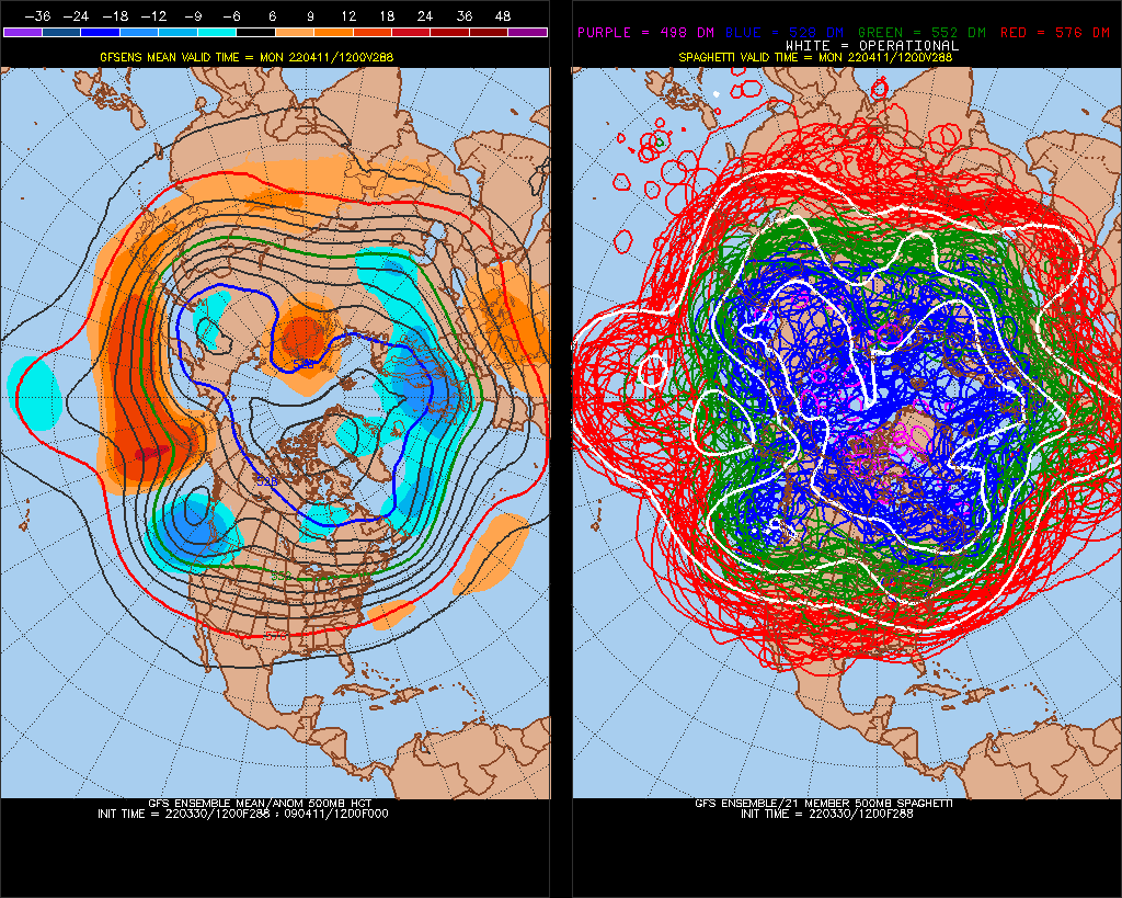
I bet some of the top La Nina analogs have this pattern 4/15-16 (-PNA).thumb.gif.0b3705a15fad8e25cbe85bbedcb3fd50.gif)
.thumb.gif.16d69cbd1d25f06275205dce5c1f091c.gif)
-
April Medium/Long Range Discussion
StormchaserChuck! replied to stormtracker's topic in Mid Atlantic
It's snowed up here something like 13/20 times in early April since I moved here. -
Healthy
-
2021-2022 ENSO
StormchaserChuck! replied to StormchaserChuck!'s topic in Weather Forecasting and Discussion
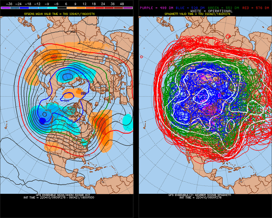
Really impressive for going-into-El Nino-analog indicators.. 4-15.thumb.gif.fd0e4a71a64d98ca2baf97a4a0c4c674.gif)
-
2021-2022 ENSO
StormchaserChuck! replied to StormchaserChuck!'s topic in Weather Forecasting and Discussion
El Nino pattern broke on today's 0z, 6z models, we are in -PNA/-PDO I think until ENSO switches again(next year) -
2021-2022 ENSO
StormchaserChuck! replied to StormchaserChuck!'s topic in Weather Forecasting and Discussion
+PNA/El Nino-transition really phased out today on models., -PDO-pattern for next 15 days. I think this will hold through the Winter, El Nino or not, and it could be something like 72-73. -PNA tendency, especially next Jan-Feb -
DCA +2.5 NYC +2 BOS +1.5 ORD -3 ATL +3 IAH +3 DEN +2.5 PHX +3.5 SEA +0.0
-
2021-2022 ENSO
StormchaserChuck! replied to StormchaserChuck!'s topic in Weather Forecasting and Discussion
Continue to think next Jan-Feb have -PNA tendency.. if we do that in a +/- wave with El Nino, I don't know, probably not. -
March Medium/Long Range Discussion
StormchaserChuck! replied to WinterWxLuvr's topic in Mid Atlantic
Seems like a Spring pattern to me.. we have that +300dm centered over Alert, Canada, and it's 60 degrees. Confirms my W->E > theory I think. -
February Medium/Long Range Discussion
StormchaserChuck! replied to snowmagnet's topic in Mid Atlantic
Do you notice how the PNA/EPO and NAO are always dancing? 1) I see Winter pretty much over 2) the +PNA this Jan and Feb might give us a -PNA next Jan and Feb, but with -NAO or AO maybe -
February Medium/Long Range Discussion
StormchaserChuck! replied to snowmagnet's topic in Mid Atlantic
Magic gravity of the 500mb High to that Alert Canada region (our highest snowfall correlation) -
2021-2022 ENSO
StormchaserChuck! replied to StormchaserChuck!'s topic in Weather Forecasting and Discussion
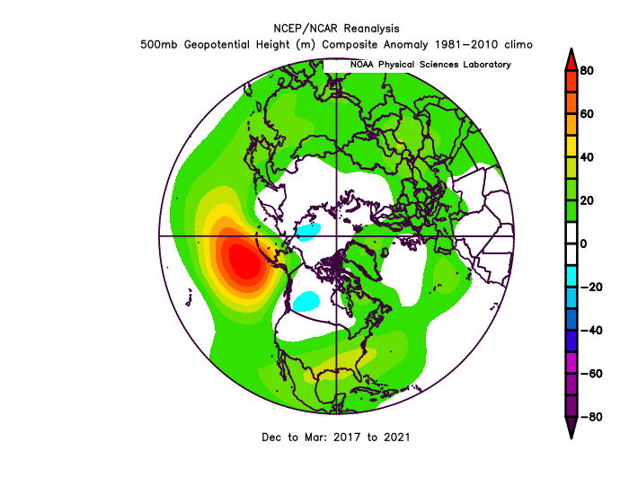
We've basically been in a multi-year La Nina since 2007-8. I don't know, stop effecting. -
Usually you don't get new ENSO state (warm subsurface-now) -change impact the Winter pattern, Dec-Mar. Usually it's first felt in April. I guess 1988 is a counter example where we had more southern stream High pressures. The +PNA is from warm subsurface ENSO (greater 500mb correlation than surface, by alot). 1) The amount of "+PNA cold" we see in the east is capped by this "law".
-
February Medium/Long Range Discussion
StormchaserChuck! replied to snowmagnet's topic in Mid Atlantic
I don't think they are beautiful looks, High pressure in the Pacific is the only real thing. -
It takes 10-15 seconds for my message to send through.
-
February Medium/Long Range Discussion
StormchaserChuck! replied to snowmagnet's topic in Mid Atlantic
Not going to snow.
-
It's silly. I don't have any money, and they are manipulating cycles in the NW. Pacific [3tries]. Stupid, evil.
-
February Medium/Long Range Discussion
StormchaserChuck! replied to snowmagnet's topic in Mid Atlantic
12 likes? 1 trophy Just kidding, but we have to break this La Nina pattern. PNA dominates+time, it's like a physics equation. -
Arctic Sea Ice Extent, Area, and Volume
StormchaserChuck! replied to ORH_wxman's topic in Climate Change
-
February Medium/Long Range Discussion
StormchaserChuck! replied to snowmagnet's topic in Mid Atlantic
I just really believe in the PNA, it's really strong signal for the state of Winter.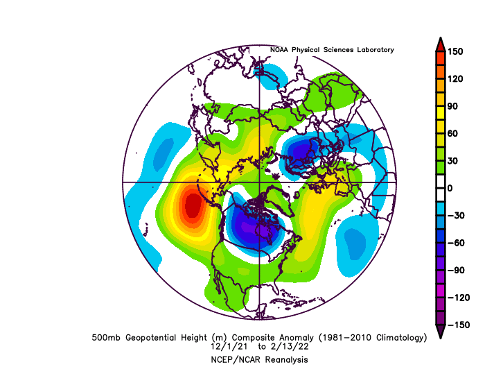
-
2021-2022 ENSO
StormchaserChuck! replied to StormchaserChuck!'s topic in Weather Forecasting and Discussion
A La Nina next Winter would be horrible with +QBO. We could have done well(snow) with El Nino this Winter.


.gif.e77795c261251ad1393e5eaa8e5dd3c1.gif)
.gif.8ab31b8f887959e34736e17cd83709e5.gif)
.gif.c408d6bd2a8cb1666a30aae0b166607d.gif)