

StormchaserChuck!
-
Posts
2,274 -
Joined
-
Last visited
Content Type
Profiles
Blogs
Forums
American Weather
Media Demo
Store
Gallery
Everything posted by StormchaserChuck!
-
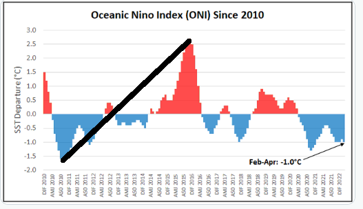
 I also think we have a higher chance for El Nino in the coming Winter's, 5/9 (warm,neutral,cold).. unless the -pool streak continues, which it might, +5-year streak or something (See Dec2010 vs DEc 2021 research). [2000 was start of cold, 2005 was start of cold, 2010 was start of cold. <They are like "puts" in the GW.]
 -
2021-2022 ENSO
StormchaserChuck! replied to StormchaserChuck!'s topic in Weather Forecasting and Discussion
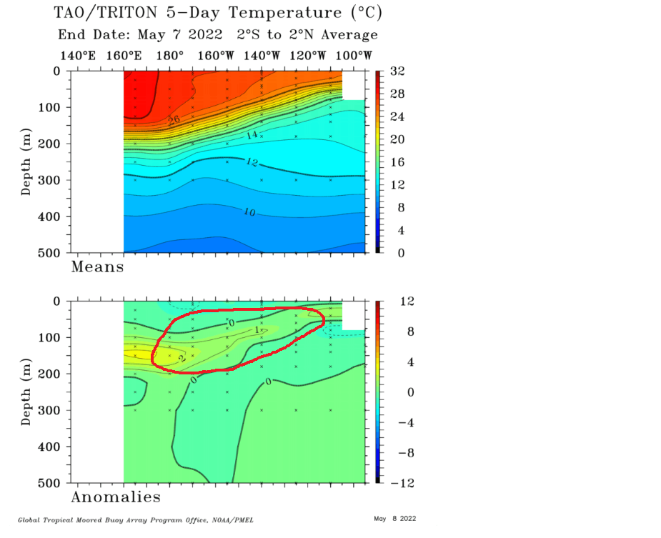
Still pushing this thing into +ENSO territory.. the Summer cap is going to correlate with rapidly rising ENSO surface SSTs.
-
Ridiculous El Nino STJ

-
2022 Atlantic Hurricane season
StormchaserChuck! replied to StormchaserChuck!'s topic in Tropical Headquarters
Wettest I've seen
-
2021-2022 ENSO
StormchaserChuck! replied to StormchaserChuck!'s topic in Weather Forecasting and Discussion
El NIno STJ really kicking in at 312hr
-
2021-2022 ENSO
StormchaserChuck! replied to StormchaserChuck!'s topic in Weather Forecasting and Discussion
That's pretty cool, it's not a La Nina across the world right now. Surface will not be negative much into the Summer. -
2021-2022 ENSO
StormchaserChuck! replied to StormchaserChuck!'s topic in Weather Forecasting and Discussion
Anyway, this is regarding the rotation of the Earth, we go from -AAM to +AAM real quick -AAM, 7 days, is LaNina, +AAM, 11 days, is ElNino-like
-
2022 Atlantic Hurricane season
StormchaserChuck! replied to StormchaserChuck!'s topic in Tropical Headquarters
Weak El Nino coming for Hurricane Season I saw this last year there was a statistical anomaly/point, let's see if it carries this year.
.thumb.gif.7476a07e7944afb248fc0bfcb94d6bee.gif)
-
Well, root for my N. Atlantic SST index (May-Sep)to go deeply negative, we are going into a Weak-Moderate El Nino for the Winter.

.thumb.gif.4d7e50e1e36911ec20b515cb4825201a.gif)
-
2021-2022 ENSO
StormchaserChuck! replied to StormchaserChuck!'s topic in Weather Forecasting and Discussion

.thumb.gif.f472277885776c5fc47d4e1e547a6444.gif)
-
1) El Nino kind of pattern shaping up in the N. Pacific starting tomorrow. 2) Land/water gradient difference remains on 500mb anomaly 3) I like the idea of warmer than normal going into the Summer. -PDO is a strong pattern right now.
-
Little to no chance we are below average for July, keep that in mind when models show strong +AO for next 15days+ (will trend slightly more -AO)
-
Let's see what happens here, 2SD +AO for May
-
Still have this warm up coming, wonder if we'll see El Nino conditions strengthen 12hr vs 384hrs
.thumb.gif.d3622832ac84d20b6a5a67be152c1034.gif)
-
Give me a break, I audibled it would even out after December though. We never broke Weak La Nina status on CPC ONI. ^Historically, there is a very strong narrow range as per ENSO strength and NPH High, this is about as stretched+(N. S. Hemipshere) as you'll may be see. (GW could be +0.3 difference, [-1.3])
-
591dm over Maine on the 12z Euro. Nothing anomalous going on worldwide (pattern-index wise).
-
Summer max contest -- final results posted
StormchaserChuck! replied to Roger Smith's topic in Mid Atlantic
DCA: 103 IAD: 102 BWI: 101 RIC: 101 -
Actually, the thing was the Dec 2010 -PNA (300dm vs 230dm#2nd place since 1948), which we then moved warmer for 5 straight years from. Dec 2021 hit 330dm for -PNA, breaking 2010's #1. 330,300,(since1948,230.....
-
Pretty satellite day, drought in the SW is not going to be breaking. That's a HIGH pressure.
-
588dm to Toronto. I'm always right.
-
2021-2022 ENSO
StormchaserChuck! replied to StormchaserChuck!'s topic in Weather Forecasting and Discussion
I think that after about the 6th, we have an El Nino-like pattern setting up in the N. Pacific for 15 days. -
I was noticing it was warm last night.. +EPO's always overperform.
-
Research: curse of the -NAO 2022 1.08 1.68 0.77 1.00
-
It was 13F a few of those mornings with snow changing to rain on the way.
-
Welp, there's a pretty nice warmup.
.thumb.gif.b32e23aa02cf8e115736423be5dd787c.gif)


.gif.0277cd8a809cbc0cc2b6ef48efaa8140.gif)
.gif.bd8943214cd880f4d4a38d0d89694bd3.gif)

.gif.e45d2d1009a9f8e3493b2959c4b4ccda.gif)

.gif.52ada2f91fda6fc86e96f0a42cbde5a1.gif)

.gif.4d85fa5693f14236d5b069bfb1191689.gif)