StormchaserChuck!
-
Posts
2,274 -
Joined
-
Last visited
Content Type
Profiles
Blogs
Forums
American Weather
Media Demo
Store
Gallery
Everything posted by StormchaserChuck!
-

2021-2022 ENSO
StormchaserChuck! replied to StormchaserChuck!'s topic in Weather Forecasting and Discussion
I keep seeing that -PNA's on LR models keep getting veered to neutral over the key-area Aleutian Islands. This has been happening for about 3 months. No 0 -PNA's actually. El Nino tendency -
Heading for El Nino.. el nino/-QBO is 65-35 negNAO. el nino+QBO is 50/50. We would have a great Winter last winter I think with El Nino because the -PNA December led +NAO January and February.. we were going in the other direction
-
Winter 2021-2022 Outlook
StormchaserChuck! replied to 40/70 Benchmark's topic in Weather Forecasting and Discussion
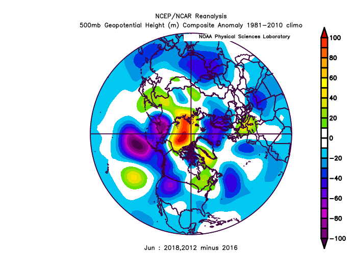
Yeah it was cool to see that ridiculous -PNA December and -NAO, then the analogs showed a -70dm 500mb anomaly over +NAO for Jan and Feb both combined 20/75 analogs! It happened. Blew the trend at the time out. Would like to see more happenings to really span it out, it's probably planetary or something. -
2021-2022 ENSO
StormchaserChuck! replied to StormchaserChuck!'s topic in Weather Forecasting and Discussion
Love to see how this El Nino intersects with -PDO.. +3 about to surface Nino1+2... US is actually leading until PDO/ENSO can prove otherwise. weak El Nino -pdo analogs.. I don't know them. 1966-67? -
Btw, what a stretch this was of PV-northern land, we almost favored -AO though
-
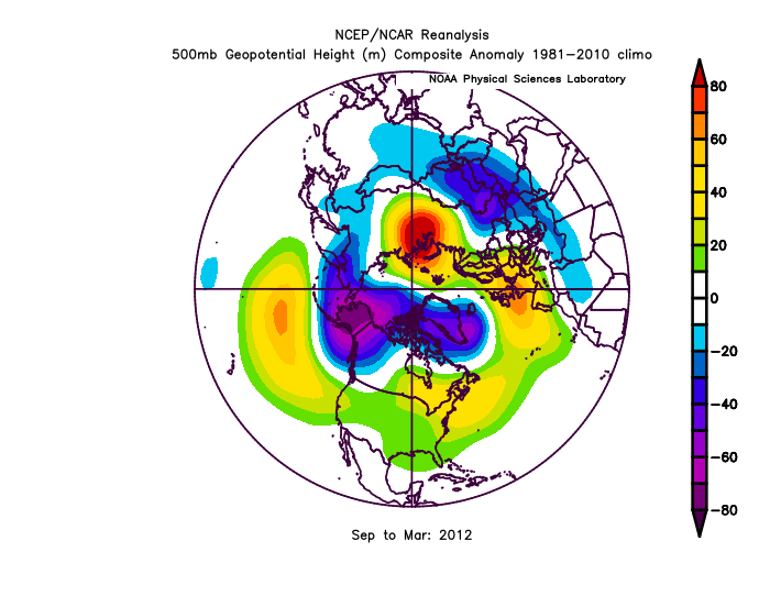
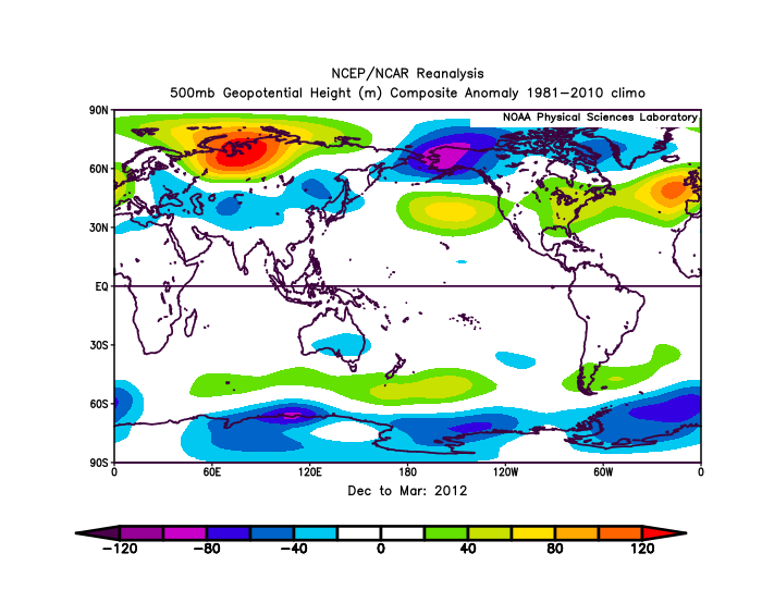
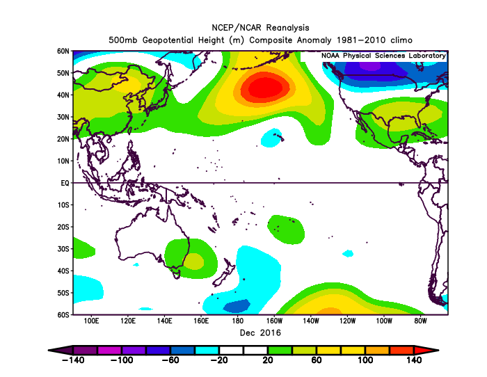
Also rember Dec 2010 was major -PNA leap (300 vs 230dm #2), and Dec 2021 leaped from that (like 360dm vs 300dm) . This is what 11-12 looked like(notice duality)
-
Kind of an evolutionary time. We have done 6 straight -PNA Winter's, and 5 February's with an average of +4SD -PNA. Let's see what happens.
-
Weak El Nino probably coming.. We have been strongest -PDO in 50+ years though.. I'd expect Alaska to keep warming(minus -EPO)-(wonder what that looks like?)
-
I expect the ridge to keep amplifying.. Galveston broke old monthly records by 3° then Anchorage did the same. It's like 10 straight days in Dallas of 102+. When the western1/2 drought breaks, I expect well above average in that area when the cycle swings back dry again.
-
Maybe a -PNA signal developing for late June into early/midJuly
-
Looks like we are heading for Weak El Nino with TAO/Triton subsurface very warm. It has surprised me that we have seen major oppositeSOI's of becoming-ENSO-phase.
-
Really cool so far v

-
It looks like 6-20, we change to consistent 90s for highs. Big move in the Pacific.. we have been +PNA so far this month. 6-20 on looks like above average with subsurface ENSO warming trend finally breaking, incycle. (The next few subsurface warming waves may be artificial +PNA's)
-
It looks like about 6/20 we have a big pattern change to hot.
-
2021-2022 ENSO
StormchaserChuck! replied to StormchaserChuck!'s topic in Weather Forecasting and Discussion
2020 was 0.5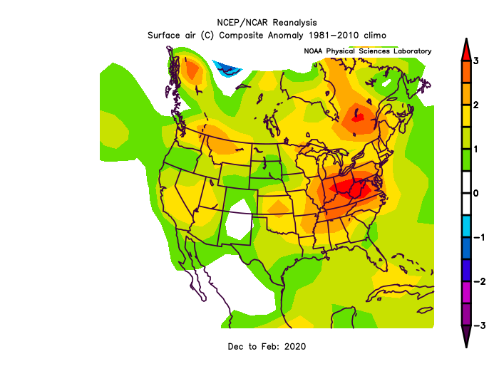
-
2021-2022 ENSO
StormchaserChuck! replied to StormchaserChuck!'s topic in Weather Forecasting and Discussion
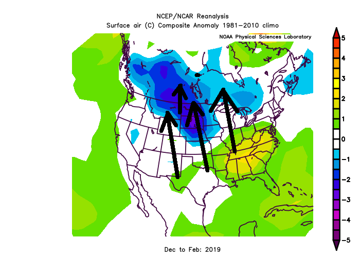
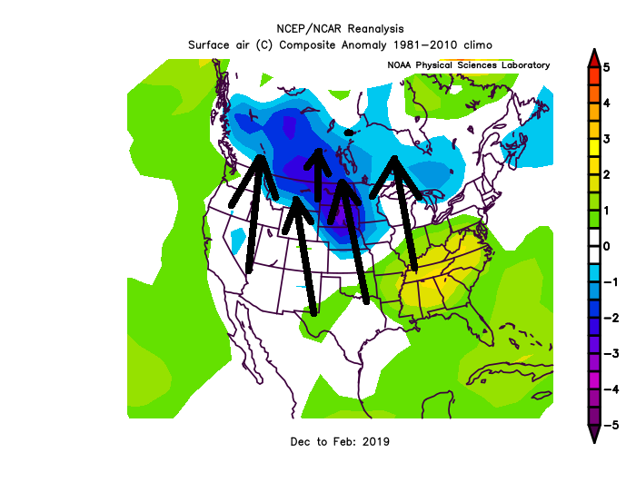
New trend vs 2019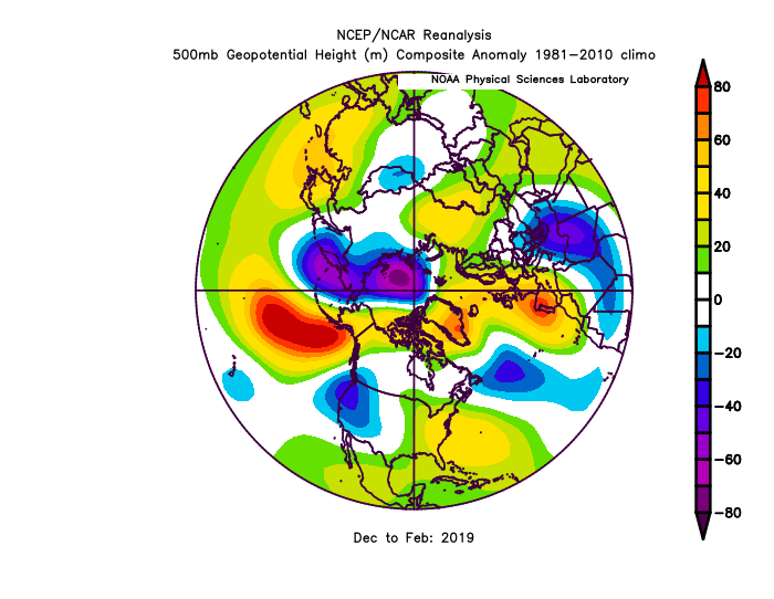
-
2021-2022 ENSO
StormchaserChuck! replied to StormchaserChuck!'s topic in Weather Forecasting and Discussion
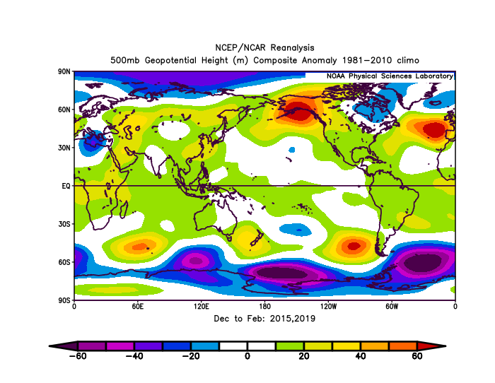
I would like 2015 and 2019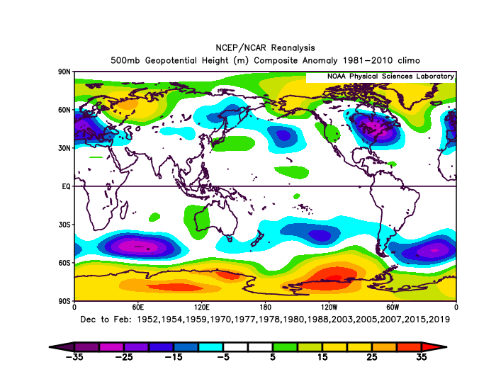
-
2021-2022 ENSO
StormchaserChuck! replied to StormchaserChuck!'s topic in Weather Forecasting and Discussion
Weak El Nino coming if this continues. -
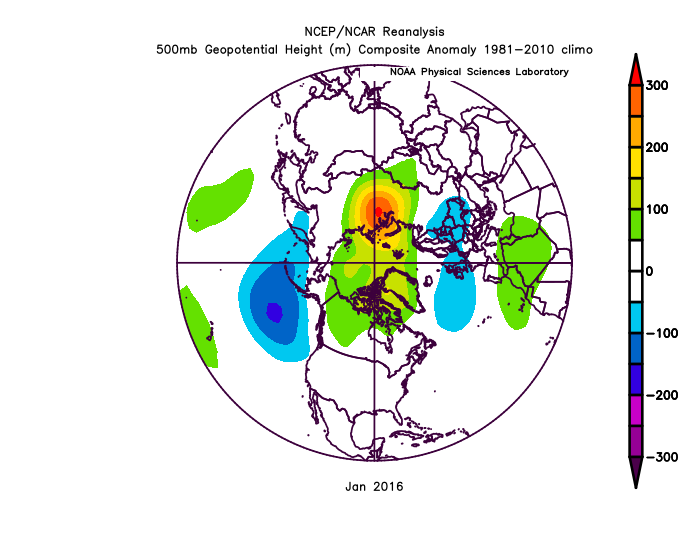
January 2016
StormchaserChuck! replied to StormchaserChuck!'s topic in Weather Forecasting and Discussion
-
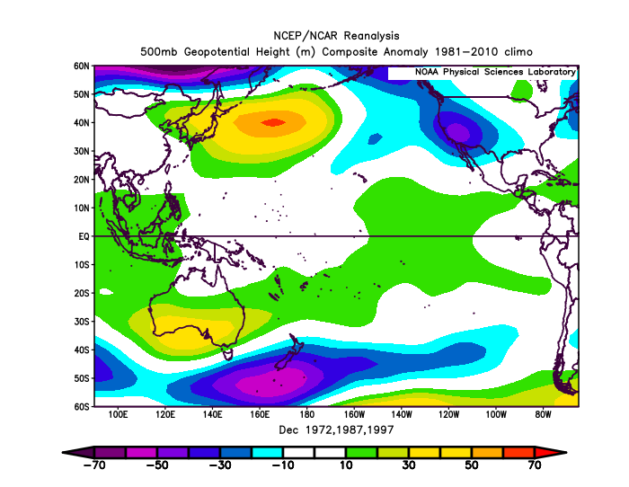
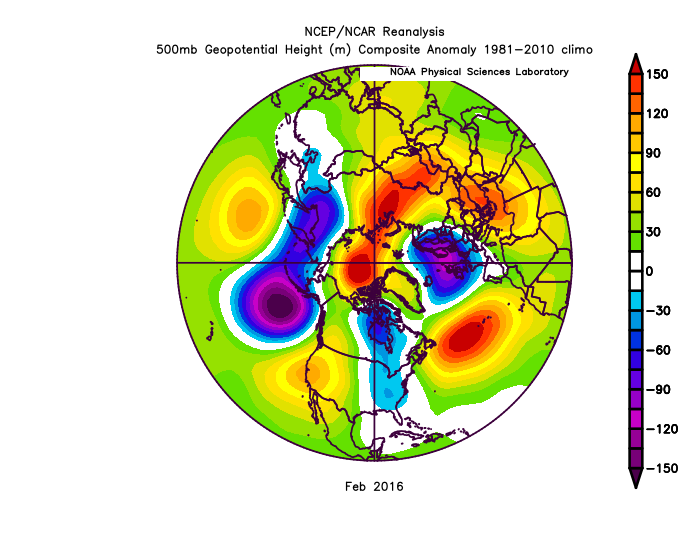
Look at this beautiful Strong Nino setup Feb broke trend pretty hard too
-
Check out the +NAO/cooler connection again.. I can see this lasting into the Winter (best chances for good Winter is 13-14, 14-15 type setup)
-
Really pumping on this ridge/-NAO connection.. could break 100*

-
I'd watch out for a spike in temperatures about here My -NAO theorem v Best -PNA window.. 6-20/23

-
Winter 2021-2022 Outlook
StormchaserChuck! replied to 40/70 Benchmark's topic in Weather Forecasting and Discussion
Nice job.. I thought early that -NAO was establishing itself, veering off later in the Winter. The SW/West coast High pressure is really becoming a feature like Global warming, a little underestimated in your forecast. That High pressure is climbing right up the gravity of the Rocky Mountains all the time now.. something to consider going forward (if the drought busts, I'd expect a stronger High pressure after in duality- that sort of thing). Really looked like up to Jan 1st that it was going to be a -NAO Winter, if so you would have nailed it at 85-90%. I give you a B+. No A- because ENSO is easy . -PNA in Dec (630dm vs 370 #2 or something) is always followed by +NAO Jan and Feb at a +70dm-100dm signal as an average of 20/75 total analogs.. ridiculous strong. So there is no real contesting that after the record -PNA December, and it could be something to remember forward if it happens again. Be careful about places like Portland and Seattle going forward.. it will be hard for them to go below average believe it or not. -
Rapidly rising Nino3.4 June-Aug
StormchaserChuck! replied to StormchaserChuck!'s topic in Weather Forecasting and Discussion
1 month later