

StormchaserChuck!
-
Posts
2,274 -
Joined
-
Last visited
Content Type
Profiles
Blogs
Forums
American Weather
Media Demo
Store
Gallery
Everything posted by StormchaserChuck!
-

2021-2022 ENSO
StormchaserChuck! replied to StormchaserChuck!'s topic in Weather Forecasting and Discussion
Check it out ^ June Pac match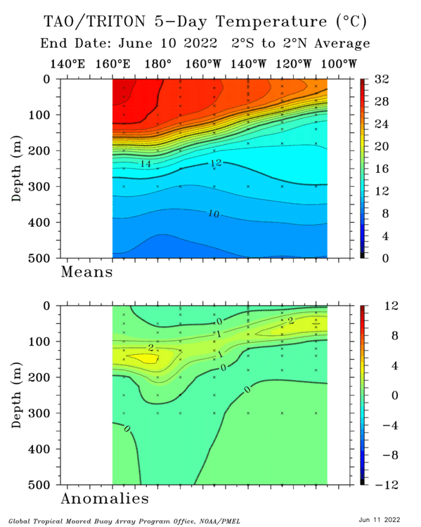
-
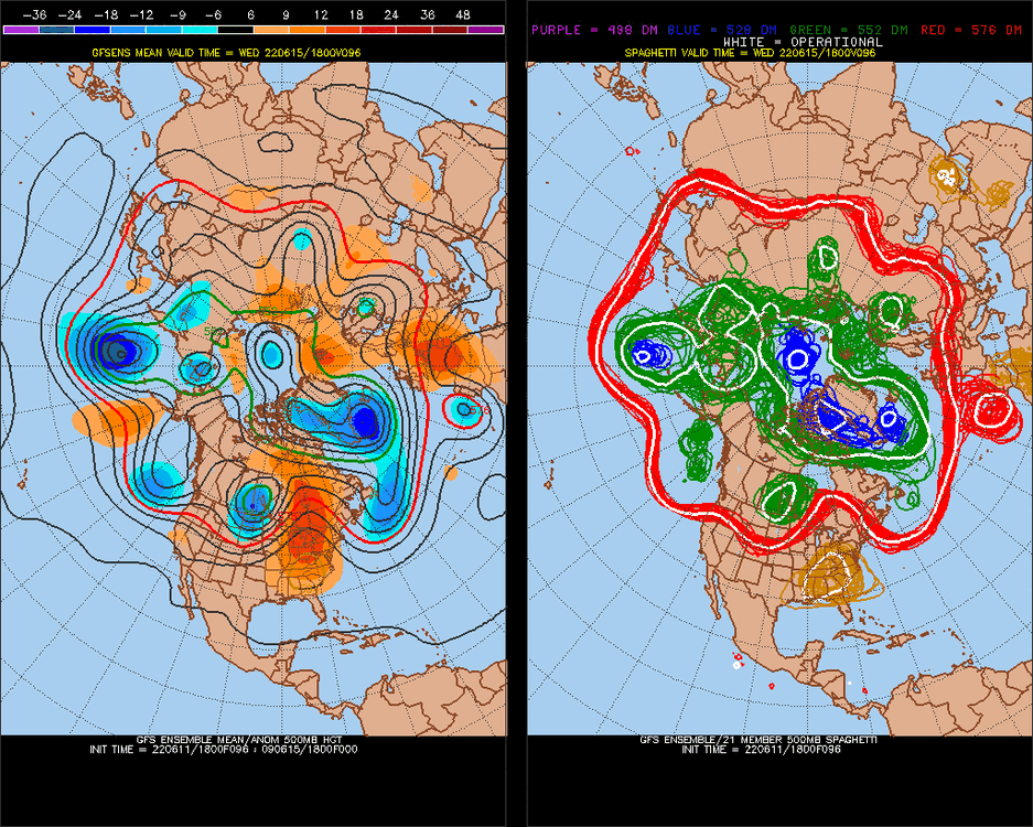
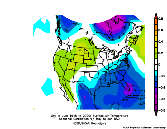
I think the coming ridge will overperform.. switching to +EPO today for the first time in a while, expect temps to go a little higher. Strong NAO correlation with same-state weather, so a +NAO first could keep us cooler, then a ridge tries to move as models have the NAO switching to negative (keeping ridge suppressed).. I don't think it will suppress the ridge. We hit 98* June 1st with -NAO, this one may do the same ~+day9-13
-
Anchorage's Record-Breaking Summer of 2019
StormchaserChuck! replied to donsutherland1's topic in Climate Change
Yeah, you just figure "it should be warmer here" -
-
2021-2022 ENSO
StormchaserChuck! replied to StormchaserChuck!'s topic in Weather Forecasting and Discussion
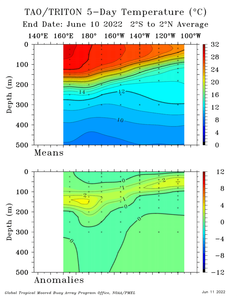
Thanks, I've compared them before and TAO/Triton seems to be more accurate, but the CPC seems to secondary to larger wave patterns, and sometimes if there is a change in the now, they will correlate with it. -
2021-2022 ENSO
StormchaserChuck! replied to StormchaserChuck!'s topic in Weather Forecasting and Discussion
The SOI was +31.35 today, daily record. Subsurface is WARM>0.0. +PNA in N. Pacific. There's your overpowering correlation again. SOI might be better as a longer-time indicator + days. -
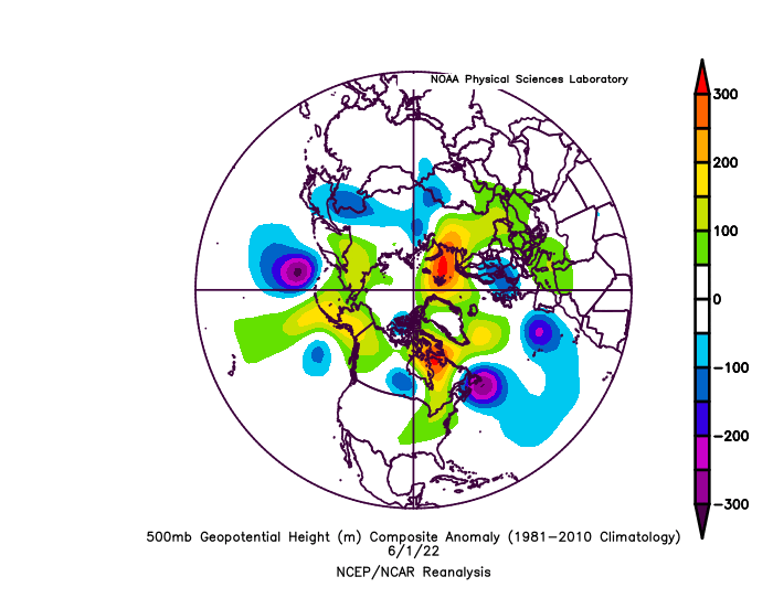
Pacific is super favorable for trough, and that is a legit correlation I mentioned it in the Winter, and ENSO subsurface is warm and surface is rapidly warming at same time.. nice short term trough potential that is realized.
-
115F in Phoenix mid-June, pretty great correlation to July-Aug above average eastern 2/3 like 0.70, or it will happen next July-Aug(2023), I say 0.90 one is above average(10yr5yr) two-years considered.
-
I watch it again and again, the cold is going to lead to this in a few days, a cold-feedback loop, US leading
.thumb.gif.bb3184246c3d833aa694d8979c5e3189.gif)
-
I should have known with +PNA, the SW, and West coast would blast. This is usually how it happens, indexes lead on LR models. First +PNA kind of organic since probably Fall 2020.
-
2021-2022 ENSO
StormchaserChuck! replied to StormchaserChuck!'s topic in Weather Forecasting and Discussion
Yeah, 3/4 3rd year Nina's have been cold though, to break the 3/3 streak. -
115F in Phoenix next weekend. SW Heat dome strengthens further.
-
Galveston’s Record Warm Late Spring and Early Summer
StormchaserChuck! replied to donsutherland1's topic in Climate Change
Now it climbs up to 115*F in Phoenix next. -
N. Atlantic SST tri-pole (vs I think opp-NAOstate(for the sake of the indicator). or vs relative EC temps) is a good indicator. So far we can go either way..
.gif.ebeebffc826cd95337d22299fc0b4721.gif)
-
Really an anomaly, Pacific is cold+PDO, -epo and +PNA there is this though
-
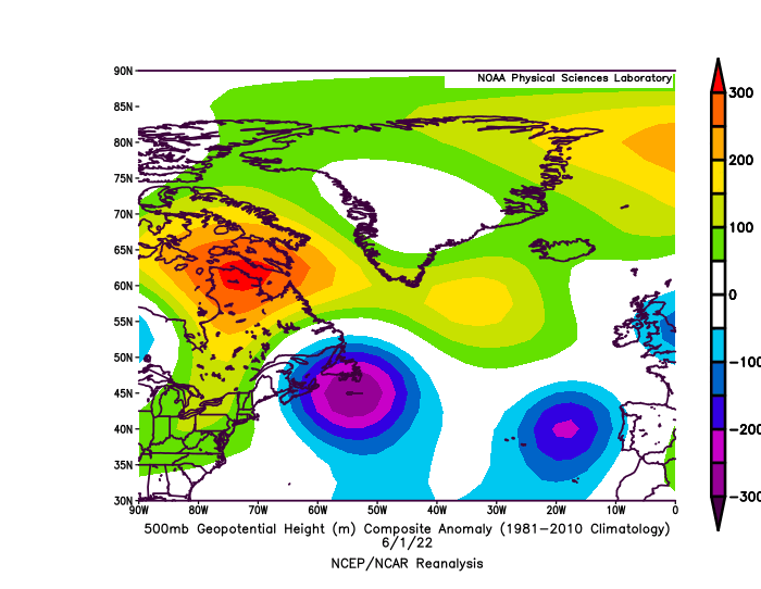
Here's your 98* day
-
Aomori/Hokkaido, Japan winter
StormchaserChuck! replied to Mercurial's topic in Outdoor and Weather Photography
Japan is pretty cool. -
2021-2022 ENSO
StormchaserChuck! replied to StormchaserChuck!'s topic in Weather Forecasting and Discussion
This isn't going to break.. next to no chance for La Nina..thumb.gif.045154a73ba5ea8fb7c816055d314b23.gif)
-
-NAO's have correlated with hot weather, very strongly now for 3+ years. The correlation is getting stronger. When I see +NAO on long range models, I think cool/damp/cloudy, -NAO is clear skies, 98* on June 1st is an example. It at least feels nicer/warmer than the actual temperatures.
-
Actually, the +PNA has completely backed off of models to GOA-low,and more -PDO pattern, we are going back to strong -PDO for/through the Winter I think (La Nina-like minus the conditions).
-
2021-2022 ENSO
StormchaserChuck! replied to StormchaserChuck!'s topic in Weather Forecasting and Discussion
El Nino prospects seem to by dying. -
2022 Atlantic Hurricane season
StormchaserChuck! replied to StormchaserChuck!'s topic in Tropical Headquarters
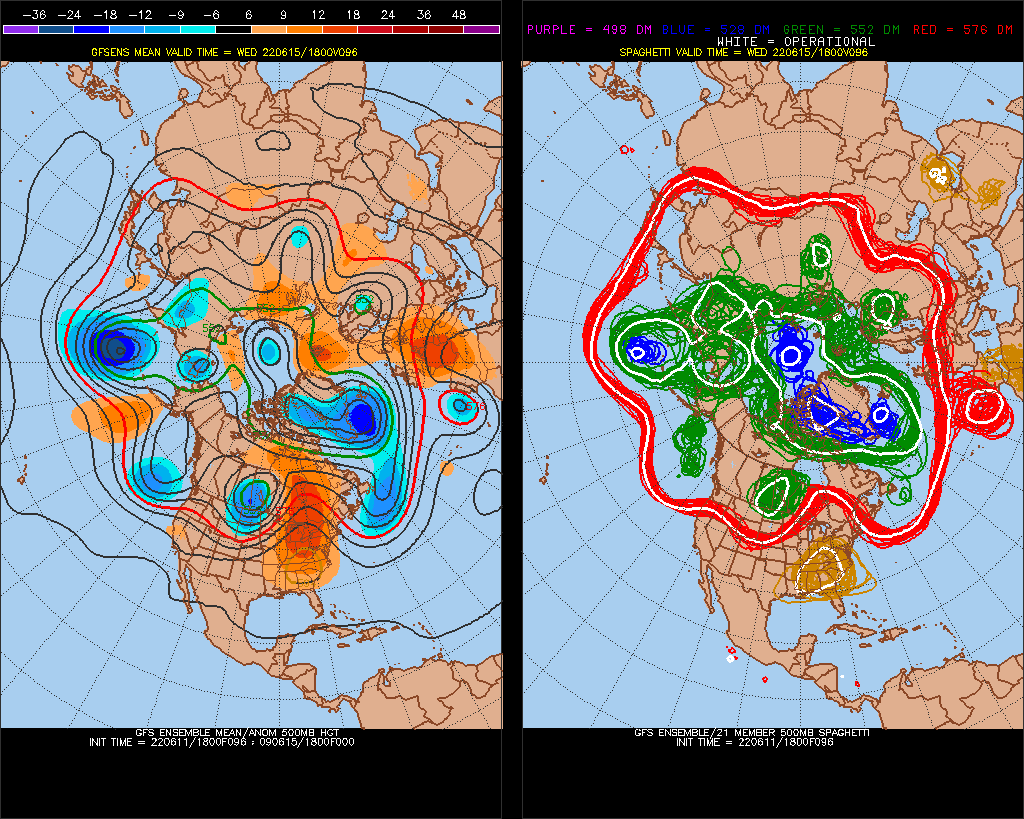
never saw this on ensembles all of last year
-
Anchorage's Record-Breaking Summer of 2019
StormchaserChuck! replied to donsutherland1's topic in Climate Change
Recent, weak -EPO that popped up recently, and none for many consecutive months going back to Oct 2021. (15 seconds to go through) -
Galveston’s Record Warm Late Spring and Early Summer
StormchaserChuck! replied to donsutherland1's topic in Climate Change
+PNA, -NAO, -EPO today -
Galveston’s Record Warm Late Spring and Early Summer
StormchaserChuck! replied to donsutherland1's topic in Climate Change
In +PNA no less. First solid +PNA in a long time.


.gif.d8e2601ed02267d11983c570f06d4e6d.gif)
.gif.304375b2b56a1ebd5c3e7bab5cc98680.gif)