StormchaserChuck!
-
Posts
2,274 -
Joined
-
Last visited
Content Type
Profiles
Blogs
Forums
American Weather
Media Demo
Store
Gallery
Everything posted by StormchaserChuck!
-
I'm liking this
-
Much colder on the west coast then.. high pressure dominates now
-

2021-2022 ENSO
StormchaserChuck! replied to StormchaserChuck!'s topic in Weather Forecasting and Discussion
I think we are going full-fledged into El Nino, quickly here now -
Somewhat worried about this configuration too
-
The same thing pretty much does appear so we'll see
-
It might be something created ontop of initial conditions.. but the N. Pacific pattern has been reverese-PNA since Jan 1 when the subsurface has been warm since Nov
-
Good post Ray.. AM/PM.. all (Sorry). You do know that ENSO subsurface > surface by 5sigmaSD's.
-
8 days of June, rain in August, September and October
-
Yeah, what's the reason for them in the first place, they are significant event? Has anyone gotten to the bottom of it?
-
Galveston’s Record Warm Late Spring and Early Summer
StormchaserChuck! replied to donsutherland1's topic in Climate Change
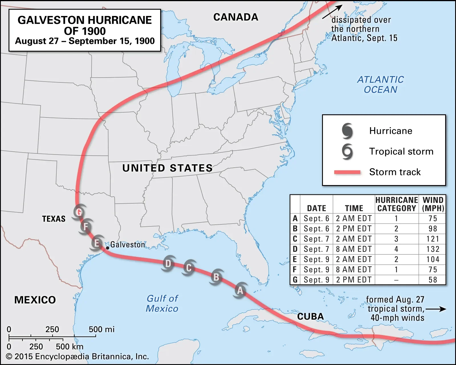
9-11-1900 just kidding
-
It's been windy here something like 3/8 days.. clear days. no reason, just 20-25mph winds, like we used to have in the 90s.
-
Aleutian low over water is just anomaly of the time.. El Nino signal is ~40-45N Low pressure (more in the Pacific and US of course).
-
Winter after Dec 2010 established New +NPH pattern that would last until 15-16 El Nino, did this, it was warm in beginning (Dec 2021 similarity)
-
Wow, CFS is good but variable. It's accuracy might be a product of money and energy traders baselining around it. I see it as outdated.
-
I think in theory they do, because of mid-latitude low pressure. As a global warming function, no A lot of the Strong El Nino's in the early 1900s were cold country-wide, I think that's what I'm referring to. After satellites they started getting warmer in the north.
-
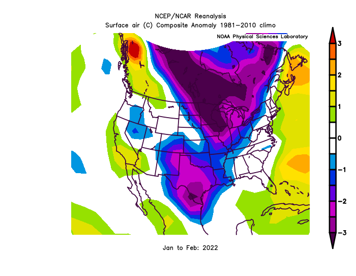
I wouldn't be surprised if we go right to -EPO/+NAO for the Winter.. following the Dec 2010 -> happening. 13-14, 14-15 were +NAO/-EPO and sometimes time warps in these instances. We were very close in Jan,Feb 2022 to Jan,Feb 2011 etc. 300dm, beat the #2 year in 75 years of 230dm. We did 360dm (vs 300dm I think this last December)
-
2022 Atlantic Hurricane season
StormchaserChuck! replied to StormchaserChuck!'s topic in Tropical Headquarters
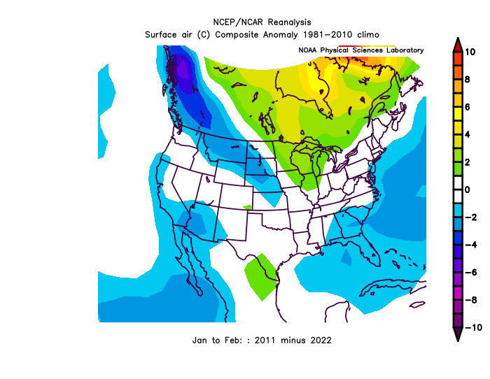
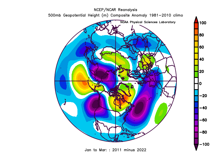
2011 is a pretty good Tropical analog.. we had record -PNA this December, and 2010 shattered that too, we followed that 2011, 2022 similarity through Jan,Feb.
-
Galveston’s Record Warm Late Spring and Early Summer
StormchaserChuck! replied to donsutherland1's topic in Climate Change
Lack of rainfall in Florida has something to do with it, I think. Watching the radar, it doesn't rain like it used to. sea-breeze fronts used to intersect middle of state. GOM SSTs -
So to be real we are in kind of an uneven atmosphere- one layer vs another, and 2015-16 El Nino was within that and "given" a good Winter. It started I think ~2012-2013. I would say Strong El Nino is our only chance for major snow/cold, but in reality we need a +3.5-4.0 El Nino to even it out. We could be given blessings.
-
Pretty.
-
2022 Atlantic Hurricane season
StormchaserChuck! replied to StormchaserChuck!'s topic in Tropical Headquarters
Not much instability but plenty of "pond-like" sit... -
Rapidly rising Nino3.4 June-Aug
StormchaserChuck! replied to StormchaserChuck!'s topic in Weather Forecasting and Discussion
models really doing this alot.. -
Galveston’s Record Warm Late Spring and Early Summer
StormchaserChuck! replied to donsutherland1's topic in Climate Change
I bet we see some kind of absolute mathematical value into the Winter months in Galveston. -
Historic Pacific Northwest Heatwave of 2021
StormchaserChuck! replied to donsutherland1's topic in Climate Change
Love this.. everyone was talking about how the Gulf stream would slow down, but the Pacific Ocean circulation kind of did. -
Historic Pacific Northwest Heatwave of 2021
StormchaserChuck! replied to donsutherland1's topic in Climate Change
Yeah, you'll keep doing this stuff especially in dry areas.