Daniel Boone
-
Posts
3,542 -
Joined
-
Last visited
Content Type
Profiles
Blogs
Forums
American Weather
Media Demo
Store
Gallery
Everything posted by Daniel Boone
-

January 2023 Medium/Long Range Pattern Discussion Thread
Daniel Boone replied to Carvers Gap's topic in Tennessee Valley
Alas, it's the hrrr...Actually, it's probably right with the scattered and banding snshrs. It usually does a rather abysmal job for far SWVA irt snowfall. Of course, that's typically with synoptic setup's so who knows maybe it does better with this type. -
January/February Mid/Long Range Disco IV: A New Hope
Daniel Boone replied to stormtracker's topic in Mid Atlantic
Yeah agree, and it seems the SST's off Newfoundland are prob. somewhat of the culprit inhibiting LP development in that particular area thereby allowing the -NAO/SER hookup. -
January/February Mid/Long Range Disco IV: A New Hope
Daniel Boone replied to stormtracker's topic in Mid Atlantic
Yeah, really is puzzling. Look forward to your findings. -
January/February Mid/Long Range Disco IV: A New Hope
Daniel Boone replied to stormtracker's topic in Mid Atlantic
The thing that's been missing recently is the 50-50. Imo, there's your main difference maker. -
Yeah definitely, northern Ark and Southern Mo is the place to be . Too bad everything is not 200 to 300 miles further east.
-
The YouTube Branson Cam is best I found, btw
-
2022-2023 Fall/Winter Mountains Thread
Daniel Boone replied to BlueRidgeFolklore's topic in Southeastern States
thanks for the invite. would love to but am covered up with very little free time. ill be up in far ne west virginia next week. may get lucky and enjoy some decent snow while there. -
Everyone check out the heavy snow in Branson Mo. on live Cam there. Just google it and use whichever outlet you choose.
-
January/February Mid/Long Range Disco IV: A New Hope
Daniel Boone replied to stormtracker's topic in Mid Atlantic
Yep, apparently...at least in this craptastic, lackluster, dud Winter. -
2022-2023 Fall/Winter Mountains Thread
Daniel Boone replied to BlueRidgeFolklore's topic in Southeastern States
Yeah, this is one of the crappiest Winters of my lifetime. Reminds me of the 1973-74, '90-91 and '91-92 Winters here. -
January 2023 Medium/Long Range Pattern Discussion Thread
Daniel Boone replied to Carvers Gap's topic in Tennessee Valley
Good discussion by them other than the lumping the entire Valley with the same High Temp Thursday. Nothing major, just a pet peeve of mine, lol. The next week to 10 days has potential.- 923 replies
-
- 1
-

-
- warm start
- cold
- (and 4 more)
-
Really weird Winter. Almost as if it's a hybrid strong la nina strong Nino. Could be +QBO, very warm Atlantic SST'S, Volcanic activity, Stratosphere and other warring factors causing so much chaos. I suspect alot of oddities will take place more often as end times culminate.
-
Cincinnati picked up 5-6 inches yesterday. At least systems appear to be gradually traversing further SE. Hopefully an overall trend for the next couple weeks. Not banking on it though in this lackluster "Winter".
-
I'm in Kingsport now and can attest to that
-
January 2023 Medium/Long Range Pattern Discussion Thread
Daniel Boone replied to Carvers Gap's topic in Tennessee Valley
Here's a link. scroll down to cams. Tri-Cities Cameras | News, Weather, Sports, Breaking News | WCYB- 923 replies
-
- 1
-
-
- warm start
- cold
- (and 4 more)
-
January 2023 Medium/Long Range Pattern Discussion Thread
Daniel Boone replied to Carvers Gap's topic in Tennessee Valley
A dusting here this morning with steady light snow. just 200 yards to my east and onward it is pouring. apparently projectory upslope. Cams in Big stone gap and Norton show what looks like 1-2 inches and snow rather heavy.- 923 replies
-
- 2
-
-
- warm start
- cold
- (and 4 more)
-
January 2023 Medium/Long Range Pattern Discussion Thread
Daniel Boone replied to Carvers Gap's topic in Tennessee Valley

- 923 replies
-
- 4
-
-

-
- warm start
- cold
- (and 4 more)
-
Good stuff. Thanks for posting!
-
January 2023 Medium/Long Range Pattern Discussion Thread
Daniel Boone replied to Carvers Gap's topic in Tennessee Valley
That Nino pattern may fall somewhat inline with the late SSW typical affect. If so, we'll some some late wintry weather.- 923 replies
-
- 2
-
-
- warm start
- cold
- (and 4 more)
-
January 2023 Medium/Long Range Pattern Discussion Thread
Daniel Boone replied to Carvers Gap's topic in Tennessee Valley
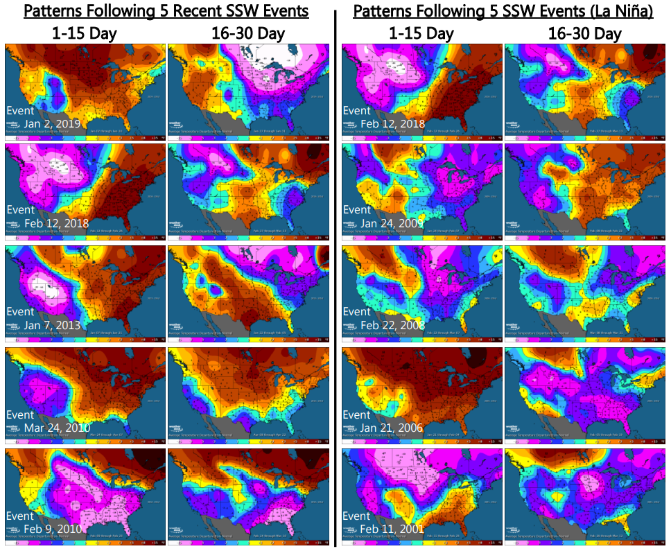
They sometimes help us irt an eastern trough and cold but, not always. Usually, once it's effects begin affecting the Atmosphere it warms up around here as heights tend to pump and many times lend to a -NAO. The downstream eastern trough is usually as Carver mentioned, 2 to 3 weeks. A rather promising study Larry(Gawx) in the SE Forum did shows that pretty much all late January onward SSW's resulted in a rather sustained period of cold and wintry Weather 10-20 days afterward. The Cold period lasted 2-4 weeks !- 923 replies
-
- 2
-
-
- warm start
- cold
- (and 4 more)
-
January 2023 Medium/Long Range Pattern Discussion Thread
Daniel Boone replied to Carvers Gap's topic in Tennessee Valley
Exactly. It definitely has been a mild Month. If something drastic doesn't happen pretty soon, the Winter will go down as another mild one. What really gets to me sometimes is when we have an overall mild winter but, have an extreme cold shot, folks say what a bad Winter it was . The balance can be 3 -4 degrees above average and they still do that. Lol. My take is, the SSW will possibly bring us a decent period of Winter weather Mid Feb till possibly mid March and that may balance the mild to near Normal.- 923 replies
-
- 3
-
-
- warm start
- cold
- (and 4 more)
-
January 2023 Medium/Long Range Pattern Discussion Thread
Daniel Boone replied to Carvers Gap's topic in Tennessee Valley
Hopefully things trend colder and we wind up with a respectable amount although, 1-3" is in this lackluster Winter, lol. Nam did have a couple degrees warm bias right up to zero hour so, something to watch if it comes down to riding the fence Temp wise during event and it's showing just a degree or two above demarcation at critical levels.- 923 replies
-
- 2
-
-
- warm start
- cold
- (and 4 more)
-
The April 1st one ?
-
January 2023 Medium/Long Range Pattern Discussion Thread
Daniel Boone replied to Carvers Gap's topic in Tennessee Valley
While we wait for our Snow, we can watch the drama in Truckee California. They have several feet on the ground and another round is just beginning. I watch this Cam pretty often. http://tahoetopia.com/webcam/downtown-truckee- 923 replies
-
- 6
-
-
-
- warm start
- cold
- (and 4 more)
-
January 2023 Medium/Long Range Pattern Discussion Thread
Daniel Boone replied to Carvers Gap's topic in Tennessee Valley
Yep. Let's hope it pays dividends this time. I have a feeling it will. If a 50-50 materializes I'll bank on it.- 923 replies
-
- 3
-
-
- warm start
- cold
- (and 4 more)