TSG
-
Posts
742 -
Joined
-
Last visited
Content Type
Profiles
Blogs
Forums
American Weather
Media Demo
Store
Gallery
Everything posted by TSG
-
65 dbz pixels on the cell West of Charlottesville
-
This morning's HRRR runs really missed on the convection in central VA right now. Moderate rain and a few rumbles of thunder in Cville the past 30 mins. 82/76 at CHO. swampy.
-
Right, with a 75 degree DP it needs to be about 95-100 to hit a "comfortable" humidity level and then the heat index is like 105+. I'll take 85, overcast and swampy every time.
-
Not when the dewpoint is 75
-
This main cell over Cville has 45k foot echo tops with some of the loudest thunder I've heard in a while
-
I see the watch is through 5am. Seems like they're fairly confident in an evolution like the 3kNAM has of the Ohio MCS making it over the mountains and re-strengthening after midnight.
-

2022 Mid-Atlantic Severe Wx Thread (General Discussion Etc)
TSG replied to Kmlwx's topic in Mid Atlantic
I swear the dog-leg turn in the Potomac causes things to spin up down there more than normal. Anyone know if this has ever been looked into? -
2022 Mid-Atlantic Severe Wx Thread (General Discussion Etc)
TSG replied to Kmlwx's topic in Mid Atlantic
Heavy rain and lots of CG lightning with this complex that's been sitting over Albemarle the last hour. Starting to get nervous with that line to my north really solidifying and picking up speed.. -
WOW @ the last few scans. Radar lighting up across central VA/southern MD
-
Epic writeup. I knew a lot of this but seeing it so well laid out is nice. Saving to share with others!
-
I'll never forget that week. It was gnarly being outside. I was working at a summer sailing camp on the Potomac and we were gathering kids up and spraying them down (and ourselves) with the boat washing hoses to keep cool.
-
2022 Mid-Atlantic Severe Wx Thread (General Discussion Etc)
TSG replied to Kmlwx's topic in Mid Atlantic
Radar looking really bad over 64 right now. Hook echo now clearly visible. Lots of rotation.. -
2022 Mid-Atlantic Severe Wx Thread (General Discussion Etc)
TSG replied to Kmlwx's topic in Mid Atlantic
That large cell WSW of Richmond has been going since 4:45pm when it was coming off the Blue Ridge West of Charlottesville. Impressive echo tops, over 50k ft now. I got to watch it march into the Piedmont from the reservoir. -
The section of the large line to the south that came through downtown Charlottesville was legit. Didn't see any hail but winds were easily gusting to 60+, rain going sideways, stormwater infrastructure quickly overloaded. Looks like CHO didn't get hit as hard based on the 5-min obs. Best storm of the year so far.
-
2022 Mid-Atlantic Severe Wx Thread (General Discussion Etc)
TSG replied to Kmlwx's topic in Mid Atlantic
some sort of triple point visible on radar? What's going on SE of CHO? There's pretty clearly some kind of warm boundary stretching across VA. Made a drawing to show what I'm talking about. -
2022 Mid-Atlantic Severe Wx Thread (General Discussion Etc)
TSG replied to Kmlwx's topic in Mid Atlantic
From my place south of downtown Charlottesville about 20 mins ago. Images are a bit blurry because of the compression. Looking SW Looking South -
2022 Mid-Atlantic Severe Wx Thread (General Discussion Etc)
TSG replied to Kmlwx's topic in Mid Atlantic
~40k ft cloud tops on a couple of those cells south of CHO -
2022 Mid-Atlantic Severe Wx Thread (General Discussion Etc)
TSG replied to Kmlwx's topic in Mid Atlantic
Latest SPC mesoanalysis has Cville back over 1500 J/kg of SBCAPE, with the 2000 line not far off. That seems like enough to work with. MLCAPE not nearly as robust, but it is changing quickly. -
2022 Mid-Atlantic Severe Wx Thread (General Discussion Etc)
TSG replied to Kmlwx's topic in Mid Atlantic
I'm thinking we have a solid chance at round two down this way. Sun is poking out and the air feels thick. We're up to 75/66 after dropping to 66/63 around 10:30am this morning during the heavy stuff. -
only a minor adjustment...
.thumb.gif.e4122c62b35fac8272289be972d03252.gif)
-
Yes. Your back yard is also not representative of overall patterns. No offense intended... but you can't tell a difference because you aren't looking at the right things. How much snow a little postage stamp of land south of Baltimore has gotten the past few winters is not a useful datapoint.
-
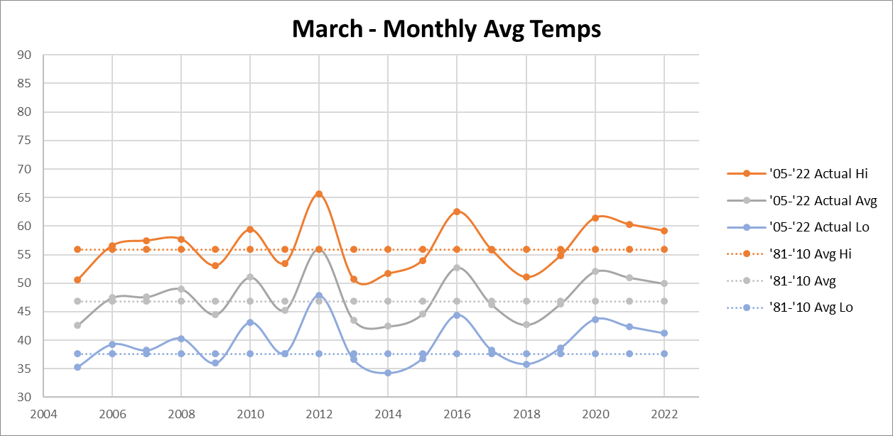
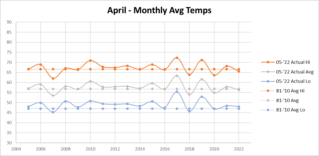
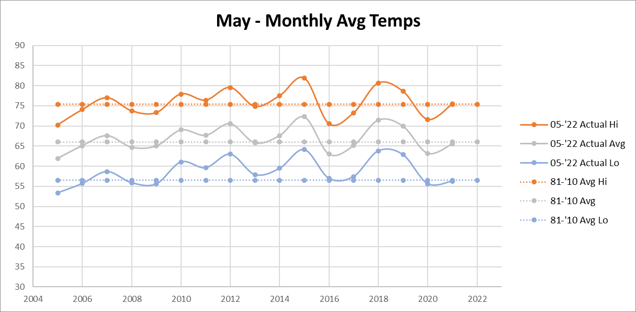
@Maestrobjwa I got thinking about this some more and I think it's important to remember we are humans with subconscious bits of our memory that influence how things feel. This year and the past two we've had above normal March temps followed by avg or slightly negative departures in April and May (20/21). In my mind this would tend to "feel" like a cold spring, especially if those warm March avg temps were brought on by a few key warm stretches towards the end of the month and not a general slightly above average regime. To have that then be followed up by weeks and weeks of the same temps would feel "cold" even if it's about average. 2018 is also in recent memory which is pretty much the coldest early spring we've had in the past 2 decades. May obviously bucked the trend that year but the memory was made at that point. My guess is those two things make the past few years seem out of place.
-
Slow day at work. Made some graphs. Data is from DCA


-
back away from the edge bud, it's mid-April
-
THE VILLAGE!! This pic just made my day. I'm a 2014 grad, lived in Eagle.


.gif.ea68cd983eeb2e5e5611eba2b4cffdd9.gif)