Random Chaos
-
Posts
902 -
Joined
-
Last visited
Content Type
Profiles
Blogs
Forums
American Weather
Media Demo
Store
Gallery
Everything posted by Random Chaos
-
-
Edit: don’t know why this didn’t embed but it’s cockpit info from a hurricane hunter. https://x.com/JeremyDeHart53d/status/1841934293066522627
-
National power outage map: https://poweroutage.us South Carolina 1,327,142 Florida 1,146,329 Georgia 1,074,671 North Carolina 452,415 Virginia 41,302
-
Seeing areas with 20"+ rainfall. https://mrms.nssl.noaa.gov/qvs/product_viewer/ Select Q3 Milti-Sensor in the product type.
-
Seeing a large cluster of 180+mph winds (highest 185mph) at 5kft on the east side of the eye. Wow.
-
Here's a screengrab of the lightening - insane:
-
Look at the velocity "waves" on the western portion of the eyewall. Don't remember seeing that in previous hurricanes:
-
Impressive winds in the eyewall:
-
Intense storms always give radar shadows and this comes up every landfalling hurricane.
-
If you have Radarscope, that is best. If not: local radar: https://weather.cod.edu/satrad/nexrad/?parms=TLH-N0B-0-24-100-usa-rad mosaic radar: https://weather.cod.edu/satrad/?parms=local-FL_Panhandle-comp_radar-24-0-100-1&checked=map&colorbar=undefined
-
Until a well defined center of circulation forms (generally when it becomes a Tropical Storm) we won’t get accurate models. The variation in the HAFS-B from 12z to 18z is exactly what to expect until then.
-

Tropical Storm Debby: Mid-Atlantic Impacts
Random Chaos replied to WxWatcher007's topic in Mid Atlantic
https://mrms.nssl.noaa.gov/qvs/product_viewer/ Select Q3 Multisensor. -
Tropical Storm Debby: Mid-Atlantic Impacts
Random Chaos replied to WxWatcher007's topic in Mid Atlantic
0.75" last Tuesday through today 2.29" last Friday through today. 10.27" April 15 through today. Send me some rain please! -
Complete wiff for me. 0.11" since the start of this storm. Guess it’s bact to heavy watering of my yard…
-
Models yesterday gave me up to about 1.75" rain by 5pm today. I have had 0.10".
-
So much for this breaking the drought hoping radar fills in but looks to be going the wrong way
-
0.1" here too, and yesterday models were predicting closer to an inch by now. Further overnight storms are way less now… we need rain. I ended up watering some of my plants mid day today.
-
Definitely accurate map. I have had 5.8" since April 4th, and excluding last night 5.44" near the bay bridge.
-
Somehow completely missed me again...it has been 2 months since I have had significant, sustained rain.
-
I have never really liked HWRF since it came out. Always preferred GFDL but that’s no longer run. Don’t know what a good hurricane model is anymore.
-
You can see the CDO is now very much displaced from the CoC, which is now towards the eastern edge of the CDO. Shear is having a major impact. I find it interesting that NHC is unsure what shear will be in 24 hours, with ECMWF increasing shear and GFS decreasing shear.
-
Looks like the eye is trying to clear again, last couple times it tried and failed, so we’ll see if it succeeds this time. One big difference I’m seeing on satellite since earlier today is there are evident gravity waves again; haven’t seen those in over 24 hours since sheer started affecting Beryl.
-
The core looks unhealthy in this 2 hour old SSMIS 85GHz microwave pass:
-
Most modern models are not built on statistical analysis unlike a lot of models 20 years ago. Most models today are fluid dynamic models that attempt to simulate the atmosphere. Errors are due to limited and erroneous data ingested (which is why you often see NOAA missions dropping dropsondes in front of hurricanes), granularity of the model (models grid the planet and each "pixel" is modeled at depth), and simplifications of the fluid dynamic equations to allow modern supercomputers to produce a result in a reasonable length of time (this is a big part of why you see discrepancies between models). Global models are typically worse at hurricanes due to lower granularity resulting in the core pressure being unable to be modeled accurately; this error tends to be amplified in deeper, stronger hurricanes. Hurricane models are typically lagged by 6 hours because they are typically based off a 6 hour earlier global model (also why you need to wait 12 hours after formation of a tropical storm before you can trust model output).
-
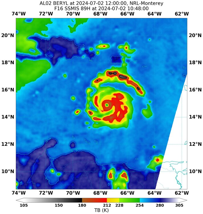
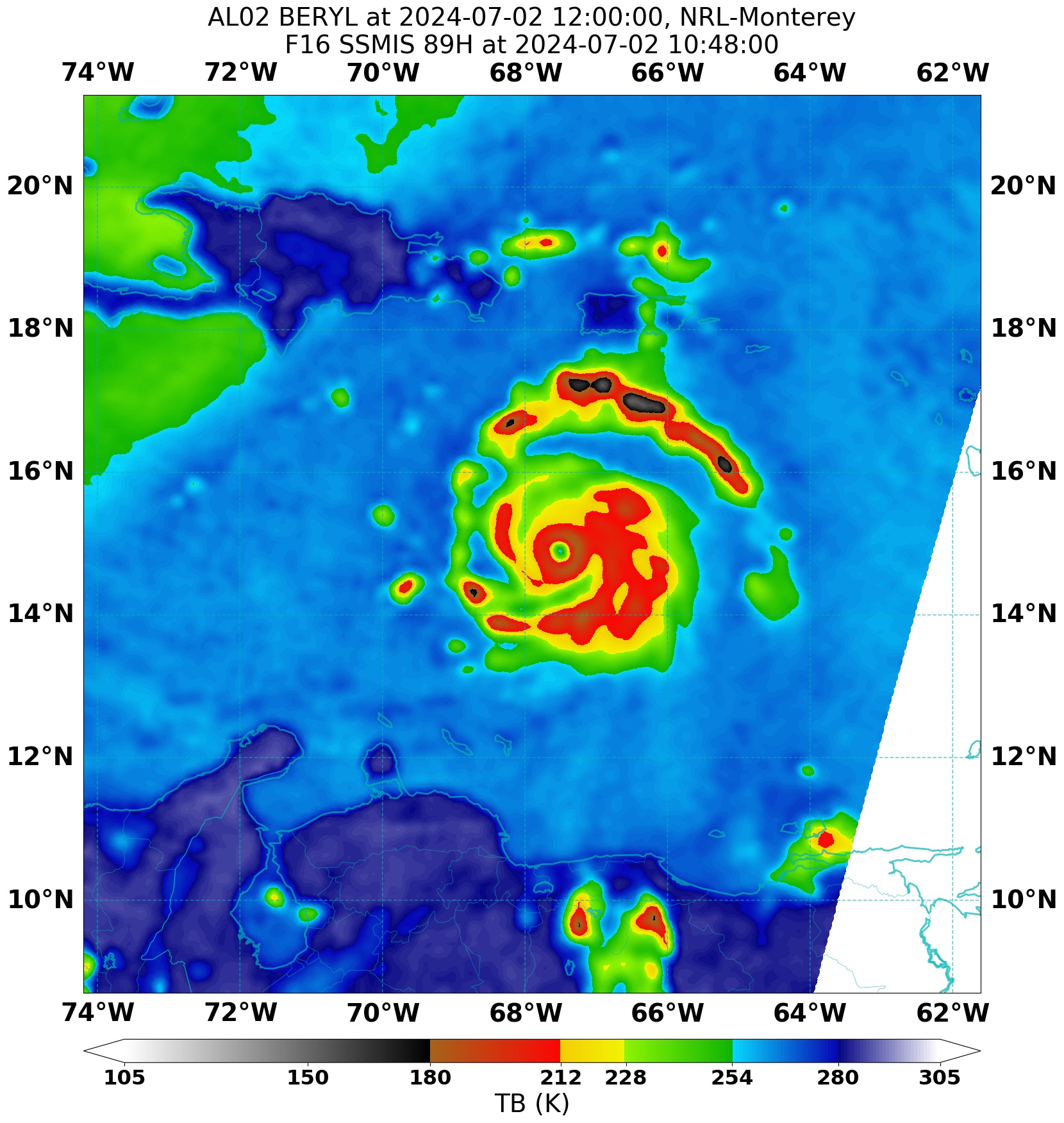
2.5 hour old microwave pass, storm looks incredible: