Random Chaos
-
Posts
904 -
Joined
-
Last visited
Content Type
Profiles
Blogs
Forums
American Weather
Media Demo
Store
Gallery
Everything posted by Random Chaos
-

Big Heat (and storms?) Week into July 4th Weekend
Random Chaos replied to yoda's topic in Mid Atlantic
0.32 on 7/4 0.69 on 7/5 0.00 overnight At least it’s something against my rain deficit. -
2026 Mid-Atlantic Severe Storm General Discussion
Random Chaos replied to Kmlwx's topic in Mid Atlantic
Saw two separate storm reports of 83mph winds just south of US50 through the Annapolis area. Looked like the main cell went just south of the 50 corridor from Parole to the Bay Bridge. I’m just north of that and didn’t get anything severe level, but lost power maybe 5 minutes ahead of the storm - based on outaged 2-3 substations on Broadneck probably all lost power, like a tree (or trees) down nesr the naval academy or along St Margaret’s Rd. Where the feed lines for the substations go. 0904 PM Marine Tstm Wind 7 ESE Cape St. Claire 38.99N 76.34W 06/12/2026 M83 mph ANZ532 MD Mesonet 0904 PM Tstm Wnd Gst 3 S Cape St. Claire 39.00N 76.45W 06/12/2026 M75 mph Anne Arundel MD Mesonet 0844 PM Tstm Wnd Gst 1 SE Parole 38.98N 76.54W 06/12/2026 M83 mph Anne Arundel MD Mesonet- 976 replies
-
- 2
-

-

-
- severe
- thunderstorms
- (and 7 more)
-
Feb 22nd/23rd "There's no way..." Obs Thread
Random Chaos replied to Maestrobjwa's topic in Mid Atlantic
35.2F, moderate to heavy snow, minimal sticking - mostly melting on contact. -
Feb 22nd/23rd "There's no way..." Obs Thread
Random Chaos replied to Maestrobjwa's topic in Mid Atlantic
36.7F here. That's already below what some models were calling for tomorrow at dawn. -
2/22-23 "There's no way..." Storm Part 2
Random Chaos replied to Maestrobjwa's topic in Mid Atlantic
Just took some temperature measurements with my IR thermometer. My measurements are for just NW of Sandy Point State Park. Soil surface temperature varied between 29.8F and 35.2 F with most readings in the 32 to 33F range. This was measured after the sun dipped below the horizon. Chesapeake Bay temperature measured 33.8F (this is near shore on the open bay, not up a river or creek). This is the same as what I measured last night. My weather station has air temperature at 45.9F I don't see temperature as a likely problem come morning near the Chesapeake Bay. As a note, there is still snowcrete from the last storm on a beach near the top of it. I also have scattered spots in my yard that still have snowcrete. -
2/22-23 "There's no way..." Storm Part 2
Random Chaos replied to Maestrobjwa's topic in Mid Atlantic
How? Chesapeake bay running 34F (I measured 33.8F yesterday) and we have a gale warning for winds off the water. Peak surface temperatures for Annapolis area will be held close to freezing from those winds. I don’t see temperatures near the water to be a problem. -
2/22-23 "There's no way..." Storm Part 2
Random Chaos replied to Maestrobjwa's topic in Mid Atlantic
Not everyone. Annapolis went from 18 ro 23” high end. -
2/22-23 "There's no way..." Storm Part 2
Random Chaos replied to Maestrobjwa's topic in Mid Atlantic
10:1 stuck a 27.9” over us on GFS -
2/22-23 "There's no way..." Storm Part 2
Random Chaos replied to Maestrobjwa's topic in Mid Atlantic
Just measured the bay temperature with an IR thermometer, 33.8F. Near shore so might be high given daytime solar heating on shallow water. Near bay bridge. -
2/22-23 "There's no way..." Storm Part 2
Random Chaos replied to Maestrobjwa's topic in Mid Atlantic
Bay is 34F right now. Not exactly warm. This is forecast for Sunday 7am: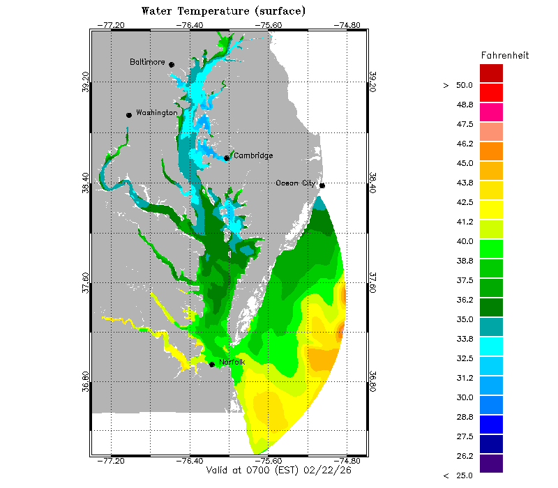
-
Feb 22nd/23rd "There's no way..." Storm Thread
Random Chaos replied to Maestrobjwa's topic in Mid Atlantic
What’s with the ptype on RGEM. Feels like the 540 line is too far south for it to be rain that far north on hr 69. -
Feb 22nd/23rd "There's no way..." Storm Thread
Random Chaos replied to Maestrobjwa's topic in Mid Atlantic
Just remember that if the ECMWF caves to the GFS, the Euro is still king and the GFS still sucks. -
FV3-Hires 0z looks good at end of run, very similar 500mb to 18z GFS.
-
I feel like GFS is back!
-
They are flying today: II. PACIFIC REQUIREMENTS 1. FLIGHT ONE - TEAL 75 A. 27/0000Z B. AFXXX 15WSE IOP15 C. 26/1830Z D. 25 DROPS APPROXIMATELY 60 NM APART WITHIN AN AREA BOUNDED BY: 30.0N 150.0W, 30.0N 130.0W, 50.0N 130.0W, AND 50.0N 150.0W E. AS HIGH AS POSSIBLE/ 26/2030Z TO 27/0230Z 2. FLIGHT TWO - TEAL 77 A. 27/0000Z B. AFXXX 03WSC IOP15 C. 26/1830Z D. 25 DROPS APPROXIMATELY 60 NM APART WITHIN AN AREA BOUNDED BY: 40.0N 175.0W, 40.0N 150.0W, 20.0N 150.0W, AND 20.0N 175.0W E. AS HIGH AS POSSIBLE/ 26/2030Z TO 27/0230Z And tomorrow: II. PACIFIC REQUIREMENTS 1. FLIGHT ONE - TEAL 74 A. 28/0000Z B. AFXXX 16WSE IOP16 C. 27/1700Z (CORRECTED) D. 25 DROPS APPROXIMATELY 60 NM APART WITHIN AN AREA BOUNDED BY: 35.0N 125.0W, 35.0N 155.0W, 50.0N 155.0W, AND 50.0N 125.0W E. AS HIGH AS POSSIBLE/ 27/2030Z TO 28/0230Z 2. FLIGHT TWO - TEAL 77 A. 28/0000Z B. AF309 03WSC IOP16 C. 27/1845Z D. 25 DROPS APPROXIMATELY 60 NM APART WITHIN AN AREA BOUNDED BY: 40.0N 165.0W, 40.0N 145.0W, 20.0N 145.0W, AND 20.0N 165.0W E. AS HIGH AS POSSIBLE/ 27/2030Z TO 28/0230Z
-
Wonder how these new models released today check out? https://finance.yahoo.com/news/nvidia-unveils-ai-models-faster-194409918.html
-
IAD Soundin
-
20.0F / 6.1F
-
Jan 24-26 Weekend Snow and Sleetfest Model Thread Part Tres
Random Chaos replied to H2O's topic in Mid Atlantic
Sterling radar showing virga at about 3000 ft beam height now, full circle around the radar. -
Jan 24-26 Weekend Snow and Sleetfest Model Thread Part Tres
Random Chaos replied to H2O's topic in Mid Atlantic
22.2/6.0 winds gusting to 32mph -
Jan 24-26 Weekend Snow and Sleetfest Model Thread Part Tres
Random Chaos replied to H2O's topic in Mid Atlantic
Those are some crazy snowfall rates at 11am Sunday on the RGEM. -
Seems as modeled to me. Right now I am 38.7F. Most recent NAM calls for 39F. 24 hours ago NAM called for 37. Seems pretty good.
-
SREFs for DCA Look good https://www.spc.noaa.gov/exper/sref/srefplumes/
-
Only reason NAM is the worst is the CRAS model got retired.
-
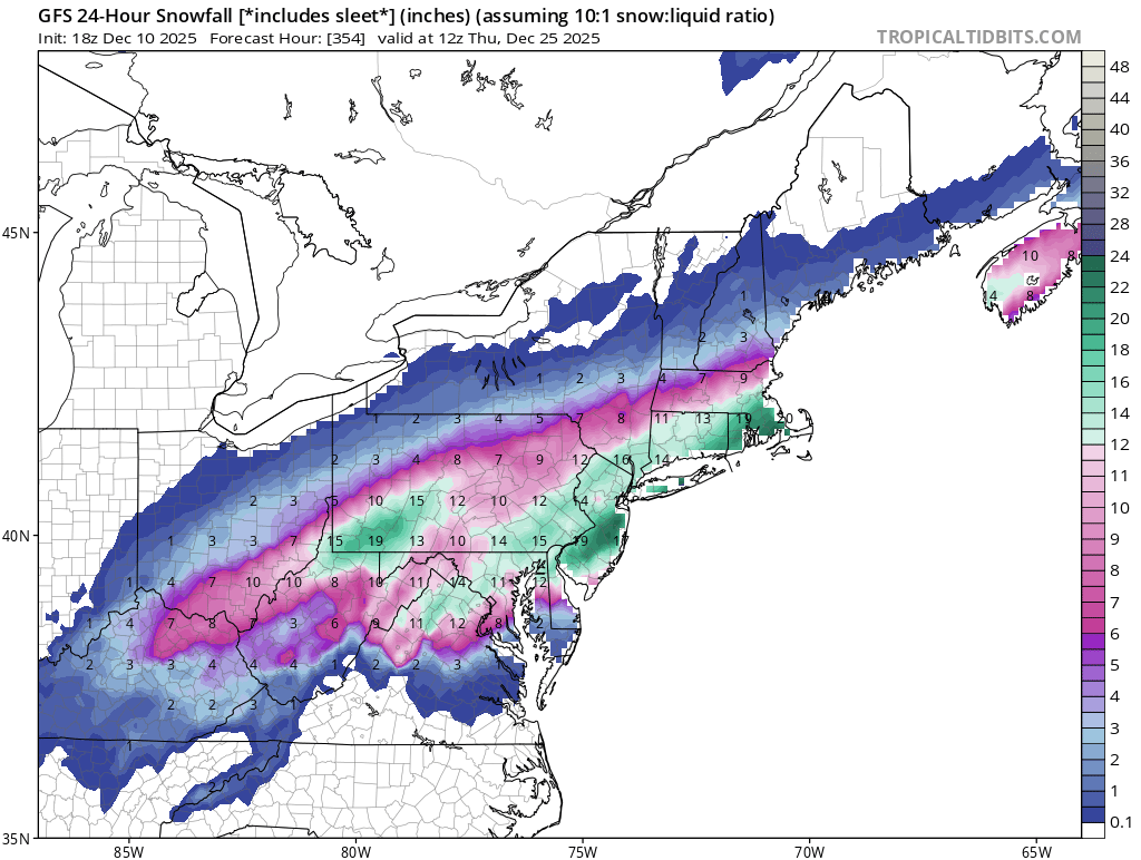
GFS has the Christmas Day storm back.