Random Chaos
-
Posts
904 -
Joined
-
Last visited
Content Type
Profiles
Blogs
Forums
American Weather
Media Demo
Store
Gallery
Everything posted by Random Chaos
-
 Most modern models are not built on statistical analysis unlike a lot of models 20 years ago. Most models today are fluid dynamic models that attempt to simulate the atmosphere. Errors are due to limited and erroneous data ingested (which is why you often see NOAA missions dropping dropsondes in front of hurricanes), granularity of the model (models grid the planet and each "pixel" is modeled at depth), and simplifications of the fluid dynamic equations to allow modern supercomputers to produce a result in a reasonable length of time (this is a big part of why you see discrepancies between models). Global models are typically worse at hurricanes due to lower granularity resulting in the core pressure being unable to be modeled accurately; this error tends to be amplified in deeper, stronger hurricanes. Hurricane models are typically lagged by 6 hours because they are typically based off a 6 hour earlier global model (also why you need to wait 12 hours after formation of a tropical storm before you can trust model output).
 -
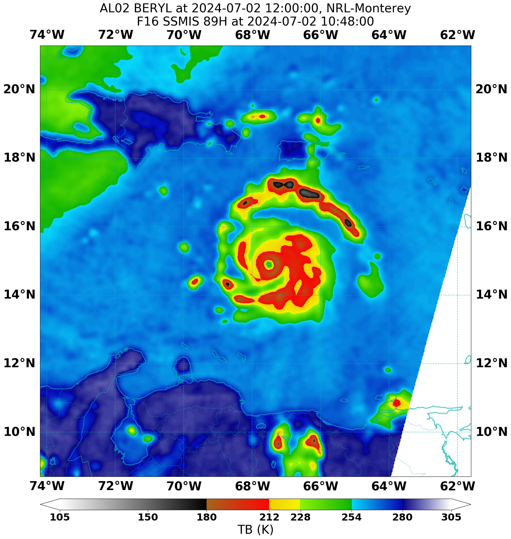
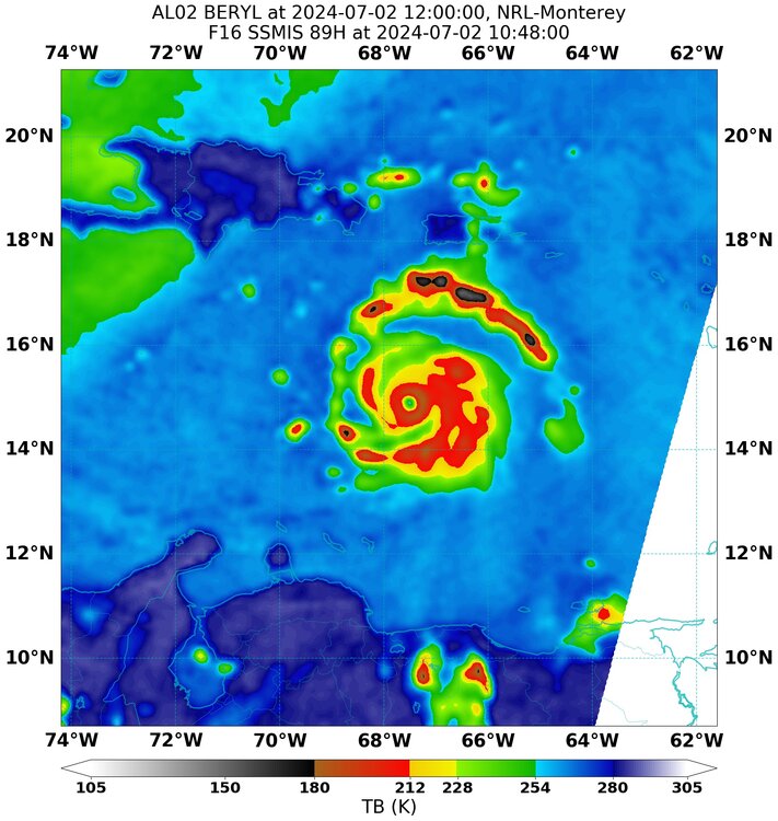
2.5 hour old microwave pass, storm looks incredible:
-
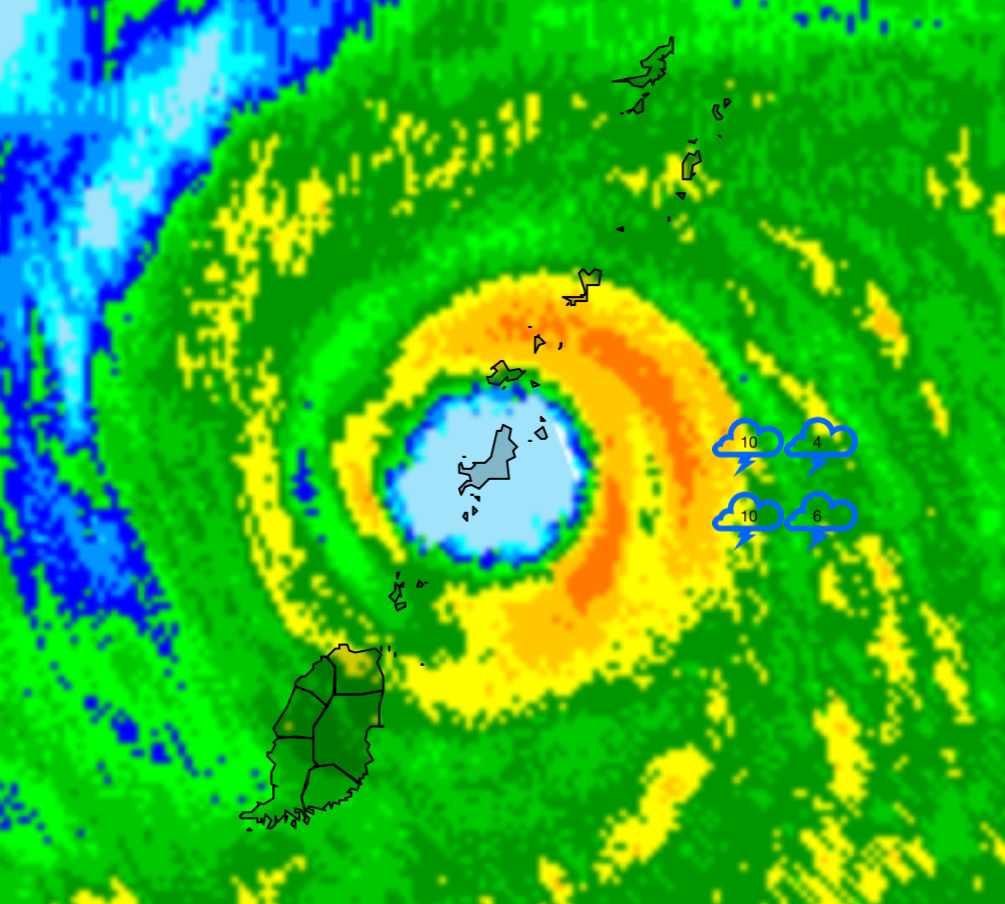
Looks like asymmetry has been resolved and eye is symmetrical and contracting on IR, excellent structural look. The lightening in the eastern Eyewall is intense and sustained:
-
Definitely waiting to see if recon finds a double wind maximum. Anyone know what’s up with SFMR on the bird that’s flying into Beryl right now? Most readings are 0, except those that are rain flagged.
-
Interesting on the strength component. Steering layers generally have differing guidance and that’s likely what it is picking up. Even if this storm weakens substantially (don’t see any reason that is likely), it will still be a very powerful hurricane. Weakening of a storm this strong often occurs by wind field expansion rather than central pressure increase. If this is the initial phase of weakening then even a weaker storm will be guided by deeper steering current guidance. Definitely can’t ignore northern tracks.
-
NAVGEM has never been a great model for hurricanes. Can’t dismiss it entirely but focus on the major global models and the hurricane models.
-
Absolutely beautiful, destructive storm. Visible: IR:
-
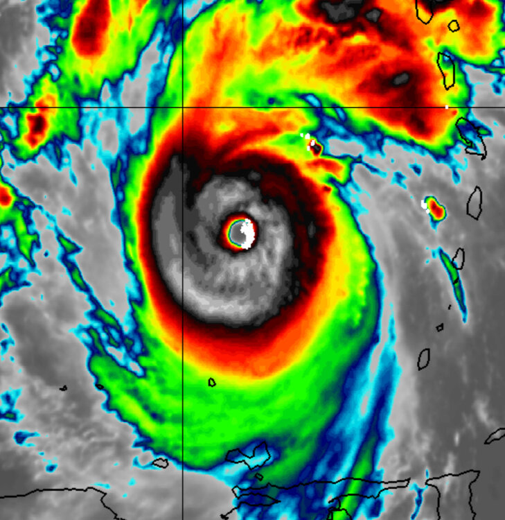
WeatherNerds satellite IR image shows incredible lightening wrapping 3/4 of the way around the inner core. Barbados radar, which is nearly out of range, is showing over 600 recent lightening strikes near the core of Beryl. The core has become very symmetric too, losing the cloud layer intrusions that were affecting it as it passed over the islands. The storm looks to be strengthening yet again, and between the NOAA dropsonde indicating 132kt winds in the northern Eyewall, the Air Force vortex recon messaging indicating 140kt SFMR winds, and the Grenada Airport (questionable reading) reporting 161mph (140kt) gust, I think it is safe to say that this storm was likely already Category 5 before this latest strengthening phase started.
-
If you look at the high refresh IR imagery (for instance COD) i’m seeing gravity waves in the hurricane. Been watching for these since rapid intensification yesterday but only showed up in the last hour or so. Often indicative of a strengthening storm.
-
Crazy jump in lightening counts in 1-2 radar sweeps (see my previous post for the last count):
-
Wow: H. Estimated (by SFMR or visually) Maximum Surface Wind Inbound: 149kts (171.5mph) http://tropicalatlantic.com/recon/recon.cgi?basin=al&year=2024&product=vortex&storm=Beryl&mission=06&agency=AF&ob=07-01-145510-21-950-132(132)-149(149)
-
A radar picture to remember this storm by:

-
Wow. Dropsonde found 132kt at the surface in the N eyewall:
-
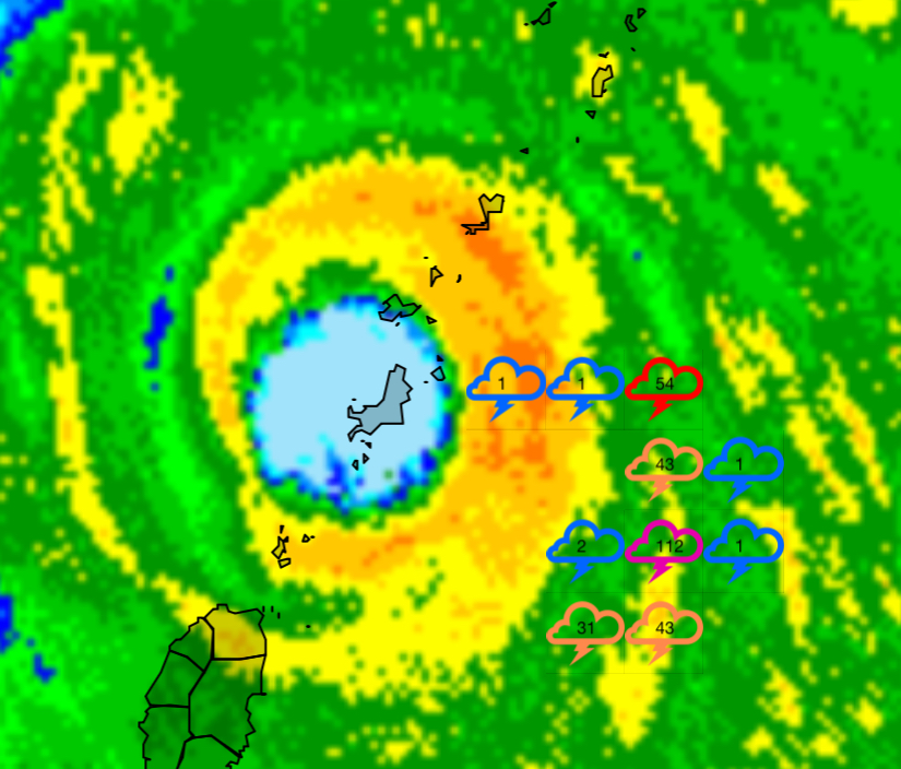
New eye is starting to clear out now. Estimating the growth during this EWRC looks like the dense convection has more than doubled the radius since yesterday. Before EWRC: After EWRC:
-
Ended with 0.50" rain, don’t think I’ll get more. And a great sunset:

- 1,696 replies
-
- 5
-

-

-
- severe
- thunderstorms
- (and 5 more)
-
More from that same post:
- 1,696 replies
-
- 1
-

-
- severe
- thunderstorms
- (and 5 more)
-
Storm over AA County looks good. I’m going to get it soon. Hopefully decent rain with it. Radar is indicating a hail core, hopefully that misses me.
-
Intense hurricanes often create their own weather nearby, impacting shear. Additionally annular hurricanes require light shear to enter a sustained category 5 state. Will be interesting to watch it in this over the next few days to see how the storm and shear interact.
-
At this range it could do anything - exact impact location is impossible to predict. However there are a few things to consider: 1. Stronger storms tend to be more likely to defy model tracks at range. Global models don’t do a good job identifying the core pressure of the storm and therefore use the wrong steering layer. 2. If it makes it into the gulf (not guaranteed given it’s got to thread the needle between Cuba and Yucatan), a very good rule is for everyone in the gulf to be on watch even if you think the storm is nowhere near you. Again steering layers are a big question as fast strengthening or weakening can cause a storm to take a very different track, and in the gulf someone is going to get hit with a landfall.
-
Amazing that for all of yesterday we had zero thunderstorm warnings and 11 tornado warnings. So rare to have TOR's without any severe thunderstorms.
- 1,696 replies
-
- 2
-
-
- severe
- thunderstorms
- (and 5 more)
-
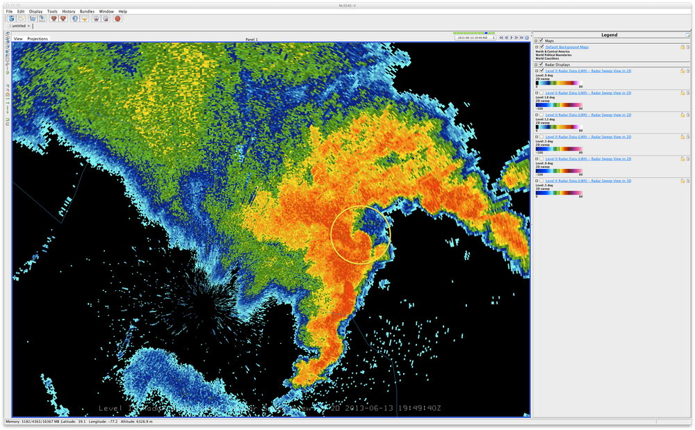
Can’t forget about the June 13, 2013 outbreak. https://www.weather.gov/lwx/20130613SevereWx And attached is that 2013 radar as it passed over Rockville.
- 1,696 replies
-
- 1
-
-
- severe
- thunderstorms
- (and 5 more)
-
-
New Warning northeast of Baltimore: Tornado Warning National Weather Service Baltimore MD/Washington DC 857 PM EDT Wed Jun 5 2024 The National Weather Service in Sterling Virginia has issued a * Tornado Warning for... Southeastern Harford County in northern Maryland... East central Baltimore County in northern Maryland... * Until 930 PM EDT. * At 856 PM EDT, a severe thunderstorm capable of producing a tornado was located over Bowleys Quarters, or over Middle River, moving northeast at 25 mph. HAZARD...Tornado. SOURCE...Radar indicated rotation. IMPACT...For those in the direct path of a tornado touchdown, flying debris will be dangerous to those caught without shelter. Damage to roofs, siding, and windows may occur. Mobile homes may be damaged or destroyed. Tree damage is likely. * This dangerous storm will be near... Bowleys Quarters around 900 PM EDT. Aberdeen Proving Ground around 910 PM EDT. Other locations impacted by this tornadic thunderstorm include Martin State Airport, Magnolia, Chase, Edgewood, and Joppatowne. PRECAUTIONARY/PREPAREDNESS ACTIONS... TAKE COVER NOW! Move to a basement or an interior room on the lowest floor of a sturdy building. Avoid windows. If you are outdoors, in a mobile home, or in a vehicle, move to the closest substantial shelter and protect yourself from flying debris. && TIME...MOT...LOC 0056Z 247DEG 22KT 3934 7639 TORNADO...RADAR INDICATED MAX HAIL SIZE...<.75 IN $$ BJL
-
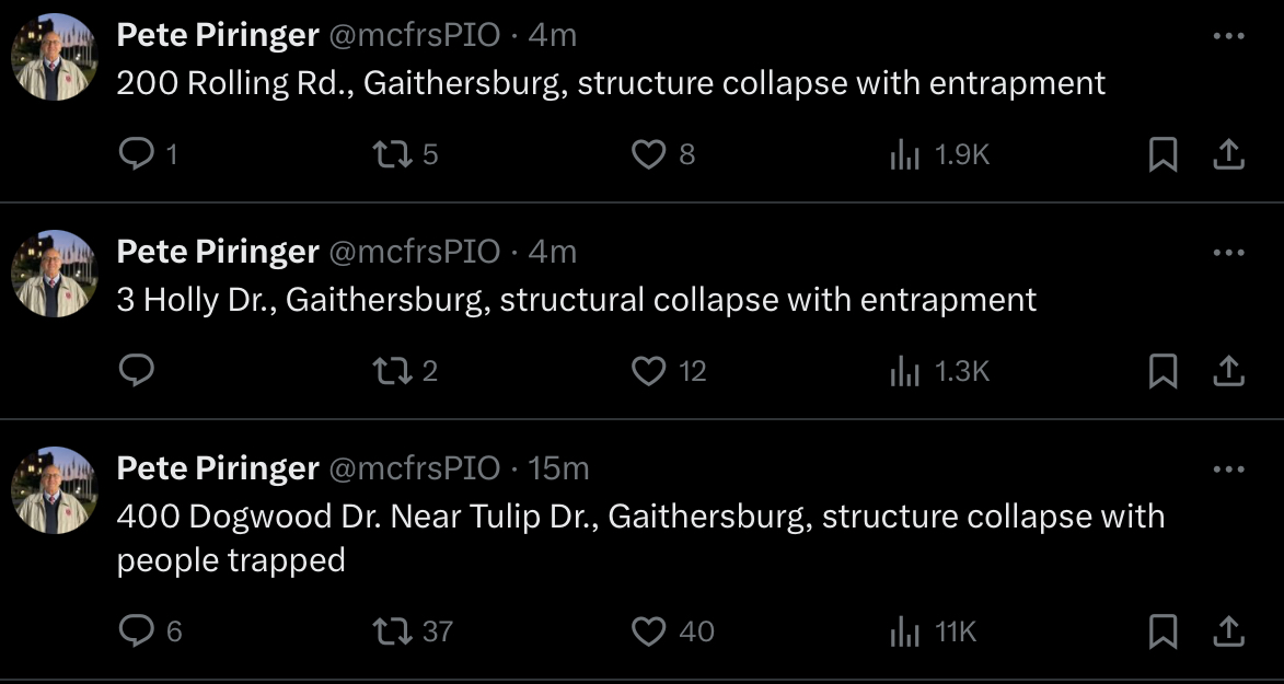
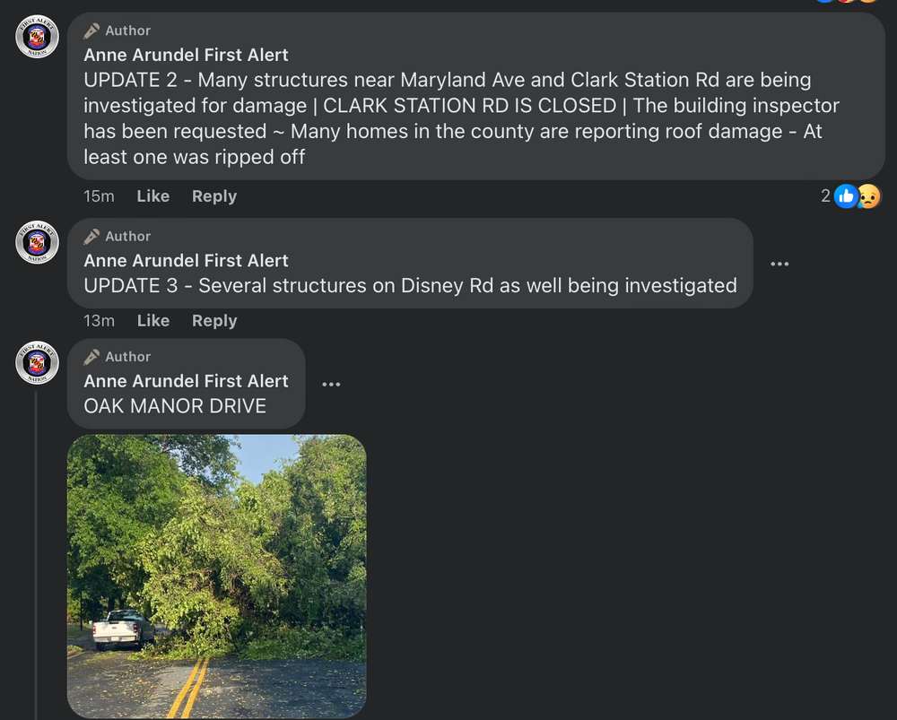
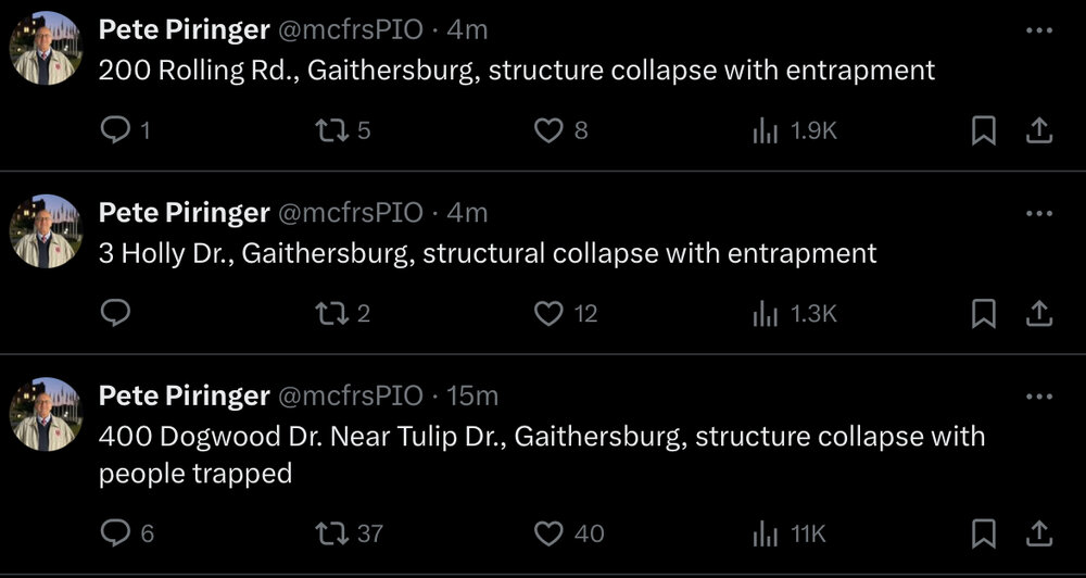
400 Dogwood is 500 ft north/south (perpendicular to tornado track) from 3 Holly. That’s a wide tornado track.
-
Looking better again plus new Tor warning