ROOSTA
-
Posts
3,146 -
Joined
-
Last visited
Content Type
Profiles
Blogs
Forums
American Weather
Media Demo
Store
Gallery
Everything posted by ROOSTA
-
Just had a shower pass through, one of those outer-outer spiral bands. .23" in one-minute. This storm seems different than other events. It's a unique feeling with dews and temp in the upper 70's. The air you can wear. In the 12yrs being here the highest wind experienced was 93mph. in Michael. Power was out for 6 days!
-
It's not the quantity but the quality of the tropical season. Only taking one to memorialize and it ain't over. Was it dust, shear or the latitude of the waves exiting the African coast? Thinking is the present threat the whole W. Coast of Florida from Tampa Bay to the Big Bend. Ground Zero.
-
Stakes are obviously higher here. So, ya'll saying there's a chance? Bring on tracking SNOW. Can't wait for the Jerry's cryosphere post.
-
Seems like just about everyone is onboard for the present wave just E of the Antilles to gain tropical characteristics. 50/50 ATT from NHC. If, a big IF... Don't know what to think. Gut feeling- It doesn't develop. Drought continues. I'm all in for a late blooming prolific season. Record breaker maybe.
-
And so, it begins. Long tracking tropical entities. Weekly formation in the MDR with several traversing come peak time. I have a bad feeling for the E Coast. Seems all the parameters are aligned. Going out on a limb here. Several, (4) Major Hurricanes tracking in the same trajectory with back-to-back LF's somewhere in the Gulf or along the E Coast. Florida can ill afford any hurricane because of insurance rates going through the roof.
-

May 2024 Discussion - Welcome to Severe Season!!!!
ROOSTA replied to weatherwiz's topic in New England
Greetings fellow New Englanders. An exciting period ahead for severe enthusiasts. I'm going to try to grace these pages with a post or two. Startin with: Blitzortung.org - Live Lightning Map I find this very informative combined with the GR product of choice. -
Just arrived back home after a stop in GA. Probably a perfect trip. The Eclipse was out-of-this-world. It took about a minute and realized...start taking pictures, IDIOT! Ended up with only 5 or 6 and only (1) good close-up. Etched in a memory for a lifetime.
-
Not a cloud in the sky throughout the event, not even a wisp of cirrus.Snapped a few pics. Truly spectacular. To pick a location on Friday night and play out as it did, I'm shocked. Might have been the best place to observe the event outside of New England
-
A Total Solar Eclipse is A MUST SEE! Not 99%, need to get into center of 100% totality. Experienced the one in '17 so for seven years I've been waiting for this one. Leaving tonight and driving to AR., MO., IL., IN. Should be enough time to chase clear skies in a 200-mile area starting at sunrise. It doesn't look good presently. I put 0% confidence in a Cld Cvr prediction. Looking at 700MB humidity combined with surface Td... OUCH.
-
Any snow is good snow. I'm pleased to see many cashing in, many more disappointed, bummer. Oh, what could (should) have been. How many times must I learn to start conservative, setting the amount and effects to high and then only to pull back? In the Winter of little still nice to track.
-
For a majority of posters in the Forum this is a hobby! THANK THE GOOD LORD!!! NEXT.....
-
The obligatory map. I'm all mapped out. There are to many maps, they all show the same thing! Should be a separate thread just for maps. Still going with an overachiever.

-
Devils in the details. Goalposts have shifted. I get it, happens every single snow event. Oh, my goodness which model is "less wrong" and choose your poison. Think about the trends and bias of each. Stick to your guns, there should be no emotional invest, no control just go with the trend and blend. Yea, TREND AND BLEND A killer CCB FTW
-
Looking good.
-
Just look up CIPS.
-
First things first. FOOTBALL It's annoying and often forgotten how bad the IMBY posts seem to overwelm the "good" posts. To those watch the game, come back and maybe by 00z things will have changed.
-
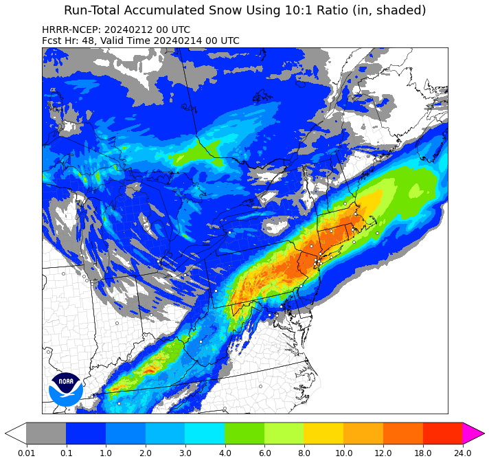
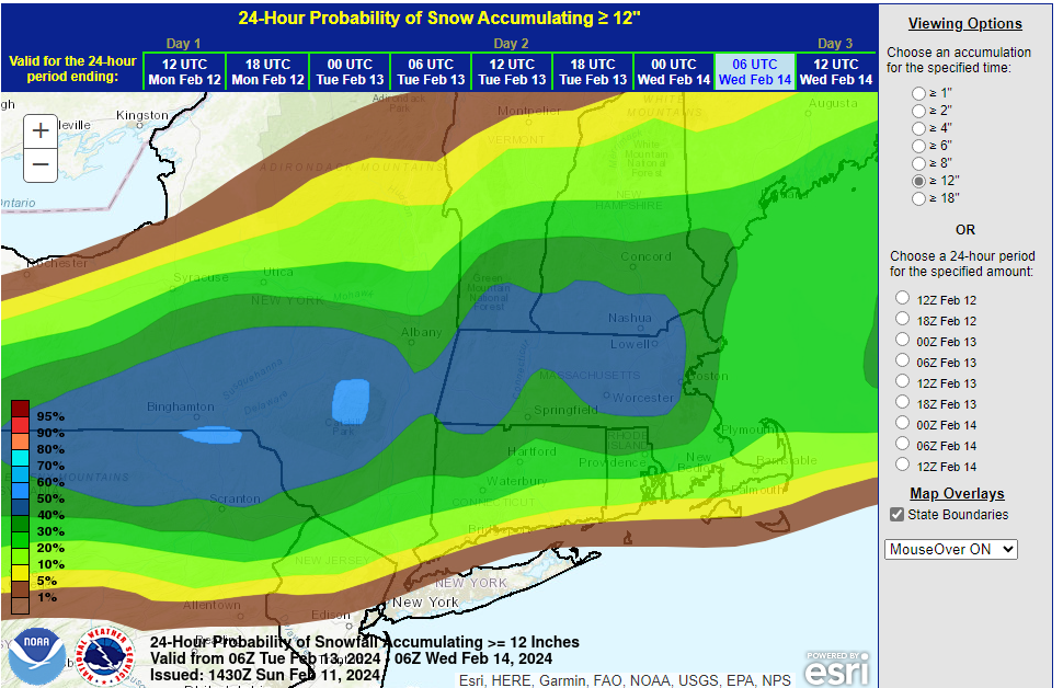
These many models depicting a good snow dump 8-12 inches can't be all wrong. A strong signal. The usual BL issues can't be known until nowcasting. A deepening system with an almost perfect track. Go with the gut feeling, mine is telling of an overachiever. --------------- Oh, I'm sitting at 82F with a dew of 68F.
-
So you say there's a chance? This looks pretty accurate! ******50%*******
-
Yes. My bad not ID'ing
-
MESO's coming in juiced. SW PA 12-18" end of the 12z run. I know...out-of-range. Just something to watch...
-
Just sitting back relaxing. Doesn't get any better, tracking a storm, Super-duper Superbowl Sunday! Soundings with QPF., blend 'em. you'll get a reasonable amount to forecast for a given location. Max SF amounts creeping up. Sometimes these events are over analyzed. In the forum it should be. A good handle on what is going to transpire. IT GONNA SNOW...BOMBS AWAY.
-
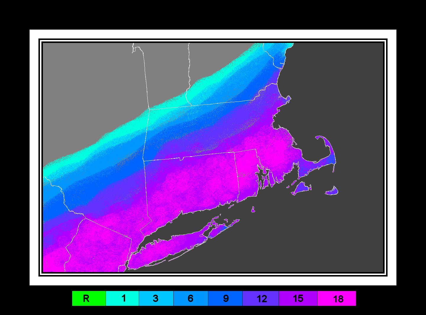
Time to throw a foot here and there, and you get foot and you get a foot. A couple of inches either side of a foot doesn't make much of a difference. "That's what she said." Go 8-10" South coast and E. Including the Cape. Getting into a CCB aka Comahead could produce higher jacks.
-
It was a Flop... February 2024 Disco. Thread
ROOSTA replied to Prismshine Productions's topic in New England
Yeah, that's present time. It's the henceforth I'm referring to. Really nothing modeled in the near term. By the time the atmosphere realigns in a week or three that then will be almost to late to enjoy. A disappointing season when all is said and done. -
It was a Flop... February 2024 Disco. Thread
ROOSTA replied to Prismshine Productions's topic in New England
Feeling it for you's guys and gals. Time to except what it is. Seems the season of which we all look forward to has been coming later, ending earlier. What up with dat? Time is running out. IMO maybe the only way to save this year would be to pull an 11th hour Blizzard.