ROOSTA
-
Posts
3,146 -
Joined
-
Last visited
Content Type
Profiles
Blogs
Forums
American Weather
Media Demo
Store
Gallery
Everything posted by ROOSTA
-
 Not even worthy of posting: BUT YEAH... any snow is good snow
-
Thinking it wise to keep expectations low, the disappointment "stings" a little less. Then when all is said and done getting more is an attitude change. No foot from this baby except maybe down-east ME. Based on (meso's) a slight drop in QPF and present temps.
-
Regionwide 2-4" W to E with a jack or two around 6" Better than nothing. Meanwhile here Severe Thunderstorm Warning. T 74F D 70F WSW wind gusting over 30mph.
-
Snow IMBY. I'll believe only when I see it. This winter so far has been a huge disappointment for many. Remember it's always darkest before the "Don" Getting one or two several inch storms at this point would be a winner.
-
Believe me, ANY SNOW IS GOOD SNOW! Except that yellow stuff. Zappa recommends "Don't eat it"
-
I'm really hoping you's all get a couple of bombs. Not to much to wish for like a 2-footer another footer and a half. I'm talkin region wide major dumpage! I think it's possible if not probable for one of those suka's.
-
I don't see a NEXT threat. End of the World stuff.
-
A depressing map.
-
This threat seems to be the most convoluted unresolved run to run pile of dung ever experienced in a long, long time. IN, OUT WTF post to post.
-
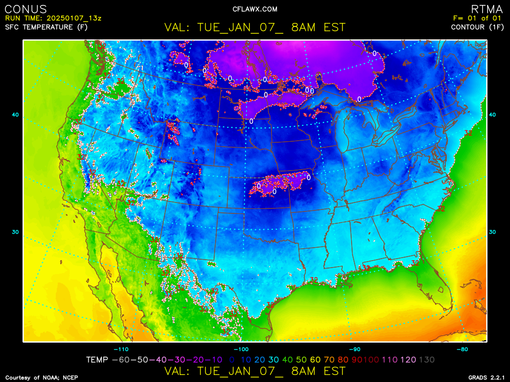
Just kicking back listening to music "PULSE" cranked on 9ch. 1500W. Puts everything in perspective. What a beautiful Temp Map of CONUS Every State with below 32F reports. The little things in this crazy world that can give pleasure and contentment.

-
I'm at 0.00. Think I'm going to stay there. In fact over the past 10yrs it's (guess) zero point zero, zero. I'm going to move to Montana. Start over, maybe raise some dental floss. Seriously probably North Carolina. Major financial distress (truth) DELETE this triviality.
-
"She's Gone...oh-oh I. I need the devil to replace her. Just one look in the mirror...what went wrong" Hall and Oates
-
I would die happy man just to see 24 flakes here. I could scratch my head, that or come into the thread and read the posts.
-
To phase or NOT to phase, that is the question. I'll always choose phase. MODEL DEJUR. I guess we'll all go for a phase!
-
Right when you think you're out... it sucks you right back in. It's the uncertainty with possibilities that I find fascinating. Always the chase.
-
WTF happened to you? I think you should find another hobby. FULL STOP The A,B,C, and X,Y,Z is meteorology, nothing but math. Once you figure it out then come back and tell us how you did it.
-
On a ship of rats, they're always the ones who jump first. I don't know who's the Capt. but this cruise is going nowhere fast. NEXT...
-
What a mess. This could be slipping away, maybe. Was hoping for something more consolidated but alas. Nothing is resolved to a definitive outcome. Anyone stating anything less or more is kidding themselves and only making themselves a target as a Debby-downer or wishing. EDIT!!! I MADE IT TO 3K. First round on me!
-
Blinded here only on cell FTL...
-
The ICON is a mess of dog doo-doo. AKA POS Atleast that run. A good football game then into the definitive Globals.
-
I will never lose my "love" attachment to New England. 10 yrs. removed I still have my accent, still follow the best forecasting (most challenging) area in the Country. No challenge in forecasting in FL. --Sunny, 20% of a mid, late-day shower highs 90-95F night lows 65-70F... day after friggin day. OCM's get paid way too much as in any is too much. Nighttime lows in the 30's Omg call out the Nat. Guard. Eastern Ma. admittedly I have a bias for as in SNOW baby, snow, snow, snow and still not enough. I miss it terribly and why I try to participate in these discussions. The Premier Forum on the Internet with SNE having the finest members anywhere especially when it comes to Winter Storms! IT GONNA SNOW!
-
Have seen big storms with less workable parameters. It is worth watching, why? It is the only game in town.
-
Have the models "in general" ever resolved energy in the SW, in timing, location and strength? Is there still a bias?
-
Delayed but not denied. Block over the "top" cross-polar flow. That screams something big this (your) way cometh. Like the sands in the hour-glass...days of our lives. Sure, one would think and expect this or that outcome. Bottom line: No two scenarios are the same. Hope lives...
-
Ensembles look good. Can see Cortez the Killer off the Baja. That would be your Crazy Horse. The way back machine is going way back...