ROOSTA
-
Posts
3,146 -
Joined
-
Last visited
Content Type
Profiles
Blogs
Forums
American Weather
Media Demo
Store
Gallery
Everything posted by ROOSTA
-
Blast from the past! Love them old daily weather maps. Had them delivered (Dept. of Commerce) for years, some might still be in the basement of the homestead in Braintree Ma.
-
DIT just passed out; his ICE fantasy fulfilled. Days if not months of suffrage.
-
 It's about friggin time! A regionwide dumpage. The lack of strong nor'easters bombing out this year? Probably going to wait for the end of March early April to ruin Spring.
 -
Tracking February 6. Light to moderate event potential
ROOSTA replied to Typhoon Tip's topic in New England
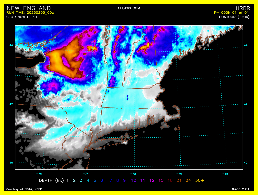
Whoops should have spelled out and amended to 48hr. sfc snow depth. -
Tracking February 6. Light to moderate event potential
ROOSTA replied to Typhoon Tip's topic in New England
HOT off the press 00z HRRR 5D total:
-
So, everyone thinking there's still a chance. Salvage the season? Reminisce of that April 1st of yore was epic. Took a personal day off from work, telling my co-workers it was going to be a humdinger. Garden Apartment in Everett Ma. awoke to the entrance buried all in about 6hrs overnight. Being removed from New England I personally would rather have seen a storm a week to track. Interest has turned into tracking, watching events regardless of location occurrence.
-
I cringe even seeing a picture. Probably to political. Here's the catch, wait and watch the defunding of The Dept. of Commerce. NOAA is essential to all forum members.
-
The problem with the 12z GFS run is: Hanging hopes on a D8,D10 run. Blah,blah,blah... it's been stated over and over again that "maybe" believe it only if it's inside D3 at least with this year's performance record.
-
New England Winter 2024-25 Bantering, Whining, and Sobbing Thread
ROOSTA replied to klw's topic in New England
Speaking about the heavens. I have a 12" DOB that I'm about to gaze upon and explore the Solar System and beyond. Heard there was a Type 1 supernova to become visible in Orion. -
Sunday Evening/Night Light snow event Disco/Obs
ROOSTA replied to Sey-Mour Snow's topic in New England
I'm a human. Plain as day. Confirms what I was thinking about some of the posts round here. LOL -
Ah, NO. Sleet is sleet Ice is Ice. To be correct: both are regarded as winter precipitation. Just about all precipitation starts as an ice crystal.
-
Trust me any Winter precip that falls is glorious. Lucky F'n pricks. Time to speak my mind!
-
76F. Who cares. Beautiful making FLoridah great once again! I have got to move...
-
BIG DOG IS COMING! It's there, we just don't see it yet.
-
Watch one huge kick in the nuts. The last threat will be the biggest snowfall of the winter. Shame the potential threats never produced and by the time it happens visions of Spring will take away the excitement. Outside of a 3' region-wide 24-25 will be caulked up to a waste.
-
Written just for Kev. Be careful what you wish for (not political in anyway) and then realize it isn't fun. Elephant in the room here. Can't control it, accept it and move on. Like, I've always wanted to experience a Major Category Hurricane. Not anymore.
-
ICE - BAD SNOW - GOOD Repeat after me... Why would anyone want ICE? Why would anyone want to lose electricity and in turn power, no heat, no internet, unable to travel to drug, grocery stores? For how long a day, a week maybe longer? Once is all it will take. Maybe wanting and getting an ice storm might break the wanting of one.
-
Nothing for his IMBY maybe?
-
I'm so close to changing. WWA issued for area (Marion)just a county N. I will die happy. Precipitation will end with a couple of flakes. This (flake) "me" can't believe and will always welcome the real flakes any-day here fLake County.
-
X has always been a no go to for me. Don't frequent websites that the owner gives Nazi salutes! END OF STORY, FULL STOP! I'm not buying what their selling. Mostly lies, profit at all cost which includes freedom. Amazing winter-mode radar! WOW
-
Shock would best describe sentiment. OCM's (LOL) trying to explain; going from forecasting 20% chance of showers to the possibility of ice-covered roads. Remember people here put parka's and long-johns on when temp drops below 70.
-
Literally (1) county to my N. warnings be close to trigger. Trend has been colder so maybe still a chance. No insulation in my house but do have heating system and fireplace. Heck I'm still in shorts and a T.
-
Not surprised in the least bit. Extreme events have and will become commonplace either side of the spectrum. Hot, cold, droughts, floods. Something going on around here. The frequency of these events is apparent.
-
To dream... I'll be only a 30-minute ride N. to seeing winter precipitation. Could be in another universe. SO FRIGGIN CLOSE.
-
Where you been? Miss ya!