ROOSTA
-
Posts
3,146 -
Joined
-
Last visited
Content Type
Profiles
Blogs
Forums
American Weather
Media Demo
Store
Gallery
Everything posted by ROOSTA
-
Might hold together
-
Nah, Give me a CAT3 or higher. /// Give me a 24hr. Blizzard You'd love Floridah WIZ
-
What a bunch of lightweights! Seasons first dews 75-80F with temps near 90F, pure tropical airmass with cobalt blue skies overhead here. Vertical vis limited by Saharan Dust Layer. Think it's going to be a Cape Verde type season. Prediction is for an active Monsoon with limited shear.
-
NICE! Quess: Where is the Cold Front? It's going to be a Hot Summer.
-
Meanwhile in Floridah, 100-105F Heat Index for the past several days. Don't mind the heat it's always been the humidity, 70-75Dews. Rain season delayed but should start a in week which is later than climo. Last CF of the season "washing-out" leaving behind just enough instability, to generate sea-breeze convergence. U can set your watch by them 4-6pm, everyday.
-
Nice little tempest. Where was this in February? 8-12" on the Rockpile!!

-
Discrete CELLS starting to spin.
-
Nice to be tracking! Primetime goodies.
-
And so it begins. I've noticed a couple of websites have gone dark. Whether it's lack of data maintenance, or personal funding of jobs. Just wait till SPC, WPC, NCEP are no longer accessible. What a shame. Eventually just about everything discussed in the Forum will no longer have any US government discussions, analysis or graphics via NWS. We could always just nuke a threatening hurricane! What a friggin joke! It was a nice run... I'm to pissed off to even consider where all this ends up... If this is to far off topic so be it and delete.
-
You's guys need a storm really bad to dissect instead of arguing over CC. Seasonal changes are predictable. I think most will agree the planet is warming. The equilibrium over the past few hundred years has persisted. Now look at it from say the past thousands, tens of thousands of years. Those changes are subtle with little analysis hard to see a trend in the changing climate. Let's keep it to 10 days. Fast forward 20k years mankind will most likely be gone as in extinct. Oh, how briefly we live upon this planet, we are only stewards. Hopefully we don't leave it toxic, uninhabitable for future generations to come.
-
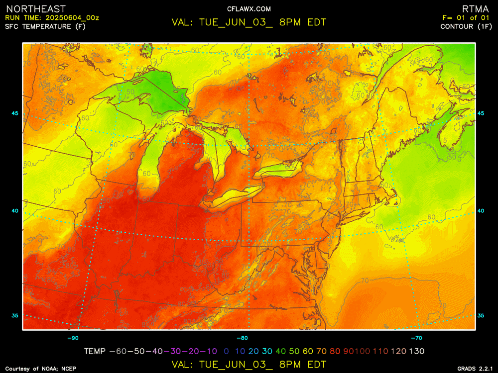
Spring be Springing! I prefer my contours and colors. Probably High temps for the area

-
I did have a natural slice which is good for that course. Summer of '82 my father told me to take it easy and relax so I did just that, 36 holes by day and a six-pack by night... Learned to move the ball left or right and deadly within 150yrds. On round really stood out, I was on fire and shot a 58, That's -14 under the course record. A Hole-in-One on 14 and a double eagle on 8. Being a Municipal (open to the public) Course they would have a tournament or two, no money but would give out "chits" which you could cash-out for equipment in the Pro Shop. Prize winnings allotted to new clubs a shag-bag and dozens of balls, gloves, shoes and clothing.
-
Early 30's. Game put on hiatus because of chronic pain, pinched nerves, herniated disc. Youth is wasted on the young. I would get too frustrated, so I don't even try. Pain is so many ways.
-
Back in the day some 30yrs ago I was a scratch golfer. Just discharged from the USAF I had the whole summer off. Joined Braintree Municipal, golfed every day and maintained a 3 handicap. The A game is long gone, have not picked up the sticks in over 10yrs. Once was golfing a round, first nine was mediocre at best. Golfing with brothers so we stop halfway grabbed a lunch. One brother was much better than the other. "How about a little wager?" 10th tee, the brother says to me after T-shots went off. "You know you just bet the State Amateur Champ." DAMN, I shot -3 under and came down to the last hole. My shot ended up about 20ft from the cup, he had a tap-in. The rest is history. I miss golfing!
-
Poetic prose. Don't change your day jobs! LOL
-
Interesting start for a thread. Reminds me of the old newsgroup (scientific with reasoning) with fewer members. Kind of makes one want to keep it scientific with statements direct on point. I might even start analyzing synoptic set-ups and forecast again.
-
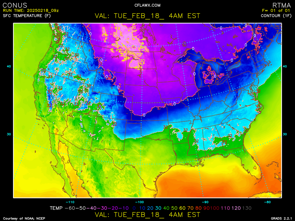
Don't ever forget 1888 for late season BLOCKBUSTERS. There is still a chance because of... Such an isothermal gradient ever presents in seasonal changes. It ain't over!
-
Back in the day when I was 19yrs old and climbed Mt. Washington in February. The most extreme conditions I have ever experienced. So bad the crew atop let me stay overnight till the conditions improved.
-
Time to break out the skates! WEEEEEEEEEEEEEE
-
You's guys are probably in big trouble (grid wise) with the accretion of ice. Kev is getting, although not as devastating as he wanted. Maybe a taste of just a little no power might do the trick of not wanting ICE. Nice little FROPA here, rain just started winds gusting in the 30mph. range with rumbles. Oh, it's 82F here.
-
I'm still in the mindset of something is going to happen. Not present threat. Maybe one BIG Powerful regionwide phaser that rivals a high KU category. All the parameters are there, (not modeled well) most of this season and go out with a memorable BANG.
-
Makes no sense giving up on this event other than "told ya so" OR "pat-self-on-the-back" Psychologically if it makes you feel better. Go for it. Sometimes stating nothing is better than resigning and then never acknowledging- yup wrong again. IT GONNA SNOW! Stick to that...
-
There is no definitive resolve at this range. Nothing is off the table. Ensemble trends are key. Something (at least tracking, watching) is going to occur. I'm not convinced to a prediction based on the OP. Stay vague and hope eternal. Something tis better than nothing.
-
Oh, the irony. Someone somewhere is going to be feeling they got screwed. Striving for perfection as in knowing you're in the jack D10 from an actual event occurring. The models never waffle, all look about the same and it comes to verify. What a boring hobby, there would be no need of the forum. Science perfected which will never happen The tracking (chase) has always been the interest not the event itself. Throw-out the IMBY mentality and just take what you get not what could have been. LUCKY SOB's Y'all don't appreciate how lucky y'all are! Back to my free airshow. F18's buzzing the sky in the 80F COC day
-
Woof, Woof! Hoping the BITE will be worse than the bark. I assume there's a New Moon? When Ginx speaks people listen.