ROOSTA
-
Posts
3,146 -
Joined
-
Last visited
Content Type
Profiles
Blogs
Forums
American Weather
Media Demo
Store
Gallery
Everything posted by ROOSTA
-
The present evolution has that appearance of something (it's called WINTER) Just a feeling I have. Thinking most in here are on the same page. Waiting for Tip to comment on one of his 10k word post... 1/2 of which words used, personally never read before. A thread should be forthcoming.
-
Live for severe events, the mundane is boring. Something is going to occur (not known yet) that will leave all in awe. An 1888 or 1978 Monstereeno that will become the new benchmark! So much for wish casting, moving right along...NEXT
-
Back to back to back. Taking it front side, back side and then DP'd. Talk about satisfying? LOL!
-
I want my SNOW! Nobody gonna take my chances. I'm probably only one of a handful of members who posts in the SNE forum who's excited about the "chance" CFL would literally shutdown if it comes to fruition!
-
And so begins Nor'easter Season. Time to cash-in now, as the next month or evolves the season depends on it...or it will blow dead monkeys. Has a good look. We track, with everything on the line. **I'D LIKE TO WIN THE MEGA-MILLIONS TOO.**
-
Weenies S and E its coming. Like watching grass grow.

-
You haven't lived there long enough to experience. Happened so many times in Braintree in can't even count'em anymore.
-
A vivid reminder of the "feeling" regardless of how much. Just to see the flakes, watch the ground and street whiten. "Maybe it will be more than". If your a weenie like I, everyone can relate? Nothing else matters when it's happening.
-
The appetizer:

-
Just to the N and W of the CF is where jack is located. Probably double the amount of first thinking. The slant ruler observer might report double digit amount.
-
 All this for 1-2", maybe 3"? IMBY bias is gone, no dog in the fight anymore. No map needed... Looking for an extreme event to get the adrenaline flowing once again. If I were still in the area desperation would be setting in, thus the emotional reactions. I get it! Pedestrian event. ***Maybe come for a visit to change the juju***
 -
Seeing an overachiever "pre-preforming" as the models turn. The s/w is powerful and its digging. Somebody is going to be surprised...
-
I'll be back... AI is some scary shit.
-
Where is the NEXT one? I'm still looking E for any tropical system. LOL Local meteorologists speaking of the next blast of cold air (drop of 10F into the 60's) so break out the parkas. Then it's only 3 days, back to the 70's and 80's. I live vicariously till I move from this gun wielding, nut-job State.
-
I never go on Twitter or "X" as its now called. The guy who owns is a nut case (very rich nut case) I will never keep feeding the rich, nor get involved in such a useless controlled platform. They collect every click, no,no electric signature from me! One of these threats has to deliver, just has to... I'm rooting for y'all.
-
I forgot the year. A strong clipper swooped down and went to town, literally bombed out. You, Phil and Messenger where barking like dogs chasing squirrels. A BOMB if I recall?
-
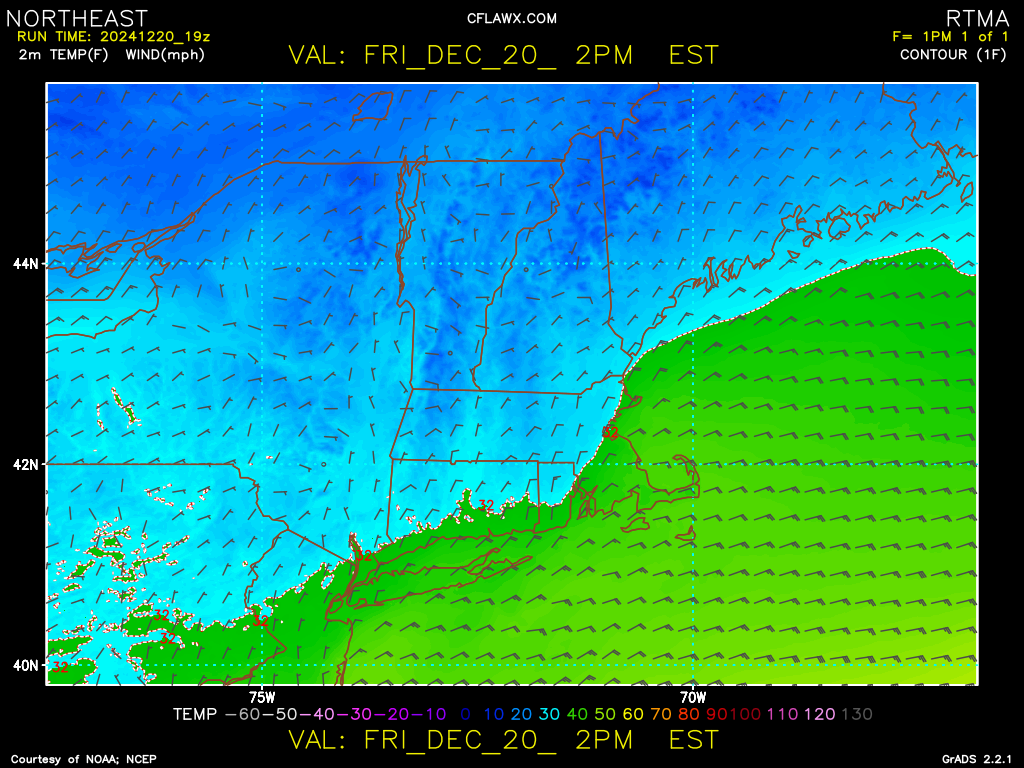
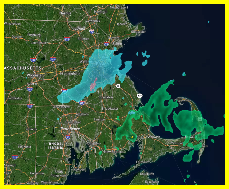
December 2024 - Best look to an early December pattern in many a year!
ROOSTA replied to FXWX's topic in New England
Love this place, ONE.....LOL said it all So close, Looks a little toasty... Here come the passive aggressive. Nice to watch from afar. -
Looks kind of toasty S of the border! How many times do you have to see the NAM off its rocker. I'm not biting yet, need model agreement.
-
December 2024 - Best look to an early December pattern in many a year!
ROOSTA replied to FXWX's topic in New England
Didn't mean to divert the thread, my bad. We all have a cross to bear. We never know what goes on behind the statement, comments, life throws challenges at all of us. Again, I'm sorry for the OT statements. -
December 2024 - Best look to an early December pattern in many a year!
ROOSTA replied to FXWX's topic in New England
Exactly. Only now starting to control. 2 types of insulin with a Dexcom monitor. Old age sucks -
December 2024 - Best look to an early December pattern in many a year!
ROOSTA replied to FXWX's topic in New England
I have 2. I take over a dozen scripts. Once you start taking them, you're hooked. Took Eliquis for a year and the clots came back. Now on Xerolta, thankfully I have a good healthcare plan. Changes your perspective and attitude of life. -
December 2024 - Best look to an early December pattern in many a year!
ROOSTA replied to FXWX's topic in New England
My highest weight was 260lbs. age-56. Forced to retire, neurological issues from a slipped disc, lowest point in my life. I had to retire because of inability to walk or commute to work. My parents passed, bookended Mom in Dec and Dad in January. So, I moved to FL to start over. One day I had a podiatrist tell me I had circulation issues. A sore, an ulcer on my big toe. Long story short version- triple by-pass, a dozen stints, developed neuropathy in both legs, clots everywhere. I lost 140lbs. I was skin and bones coming in at 120lbs. My last visit to the hospital was due to DVT. Talk about painful OMG. Doctors stated I was terminal and that I ran out of procedures, no more surgeries and that the clots are going to kill me. Here one minute gone the next. TMI I REALLY WANT TO SEE YOU GUYS GET BURIED. I'll bet buried the other way... LOL -
December 2024 - Best look to an early December pattern in many a year!
ROOSTA replied to FXWX's topic in New England
It's 83F with a dew of 72F -
NEXT.... In search of an extreme event. I do believe that there is a big-one in the deck of cards this season. aka HECS, a triple phaser. These 6-12" tracking for days just don't seem to cut-it. I want to see a cross polar blocking pattern, massive trough negatively tilted, SJ, NJ, banana 1050 to the N much like Sandy or the Perfect Storm backs in and stalls. Hey, one can dream.
-
I left on the 01-12-15. If I only knew without a doubt would have stayed. First big snows hit a week later... No indication what-so-ever to what was going to happen. No idea that my health was going to fail either.