ROOSTA
-
Posts
3,146 -
Joined
-
Last visited
Content Type
Profiles
Blogs
Forums
American Weather
Media Demo
Store
Gallery
Everything posted by ROOSTA
-
 A brushing. Industrial strength wire brush. ATT Not an OTS solution, not a direct hit. Subject to adjust accordingly. NEXT
 -
It will only take once. No A/C, no heat, all the food in the fridge goes bad. Having no electricity for a week (been there done that) is tough, after a week it's brutal. Can't go eat somewhere, ATM's are down. At night nothing but a lantern and or flashlight, celI service goes down even if you have a charger it does no good. I learned the hard-way. Extremes are what we post for. Some events shouldn't be hyped or wished for a hurricane is one of those extremes. Go chase one, experience the fury outside your hood then you'll understand. Can't compare a hurricane to a snowstorm.
-
Insurance Co. SUCK! I was in the hospital for an extended stay, triple bypass. I had a leak in the bedroom bath, came back to mold everywhere. I contracted ServPro (i would never recommend) Claim adjuster came out and approved claim. I could go on...8 months later, 35k lighter. Insurance paid dime to dollar. I considered a lawyer... Next time I will get 100% cost of repair! LEE TRACK: 40/70 or bust.
-
Disappointment galore, even if Lee somehow tracks W of the envelop now unfolding. Will it be considered a LF'ing hurricane? Little semblance of what is once was, more like a mid-lat strong cyclone. Moving to slow to keep a compact inner core, weakening, expansive wind field. Probably the greatest threat will be from scattered flooding from 5 days of rainfall. Surf and swells with coastal erosion.
-
Regardless of eventual track. East facing coastal beaches, WOAH! 20-30' breakers almost certain to make for a Photo Op.
-
Known as the Gandolf effect, "Thow shall not pass," -70W I don't believe for a second, the stall is plausible. Still time as the Long-wave pattern re-orients. Come back in 5 days, guaranteed all will change. Believe what you see but don't give it a definitive - this is going OTS.
-
Beware of very intense Hurricanes on occasion will insulate themselves creating their own surrounding environment. I would never write off any system that has yet to pass any given location in the path.
-
Best of the Summer, many discrete cells, several of which are rotating.

-
The NCAR RAL website had to add 20kts. to the intensity graph. One model (NVGI) goes almost off the scale.
-
There was one storm I don't recall the year or the name. Every single model had the system being influenced by a trough entering the Lakes and of course the Atlantic High. It sat and meandered for what seemed like a never ending loopy-loop right off the NC coast. Written off as a fish. Well, even the best forecast, models, synoptic set-up can run amuck. I bet dime to dollar few believed what the ECMWF initially showed for Sandy it was an outlier, so far out (in a different universe) it was written off. As strong as these tropical system get I remember reading somewhere that UL LL Dynamics dictate track dependent on the strength, size, location. But of course grasshopper. I have to go look that storm up..."I'LL BE BACK"
-
Look for the orientation of the Ridge, Trough, timing strength. ATT that's all you need to concentrate on. It's going to change. Bigger question is does Lee strengthen to Wilma catagory?
-
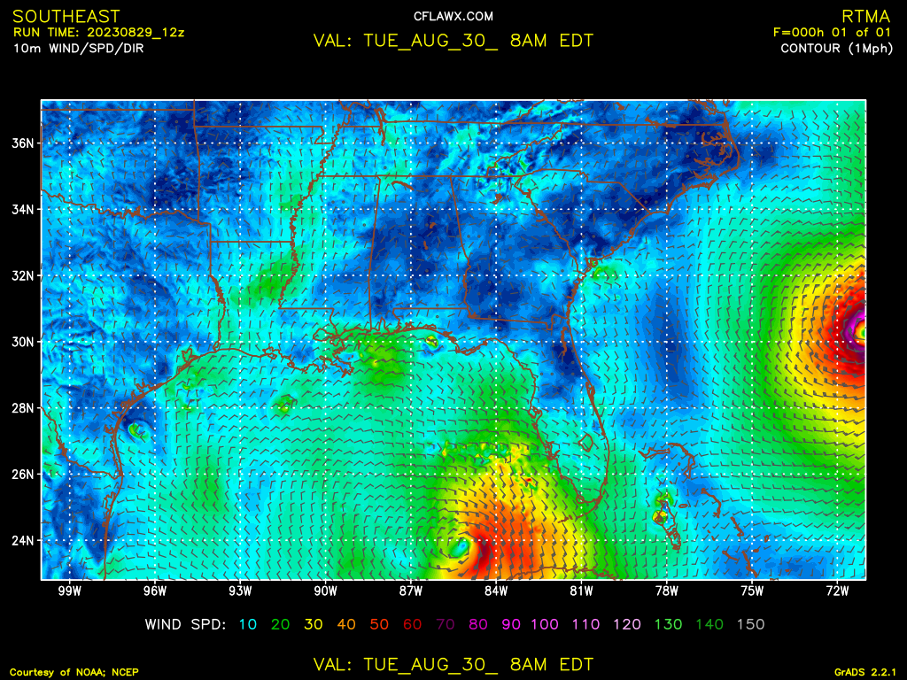
Blitzortung.org - Live Lightning Map Took a couple of days to get ready, pull an all nighter- getting old sucks. Up till I lose power.
-
What a scary looking MOFO. About 10 minutes from getting into the outer core envelop here. Thought about a chase for about 0.009 seconds. I kind of like being among the living. I should get some decent gusts.
-
I'm liking this- a huge gap between spiral bands. Surprising but figure the longer the better , keep power on. Thinking now the strongest winds will be on the backside. Water surge around Cedar Key 15', that is insane and will wipe the countryside clean.
-
First feeder band descending on the hood, downstream gusts 40-50mph. How long will power stay?
-
"Apologies to that one dude whom I triggered, but here is my Final Call....feel free to not read or look because I am insignificant." Don't let anyone get in your "space" Your appreciated, a valued weather nut. Happened to me on numerous occasions, getting called out. I went off! once. Today I regret my actions and comments just the way that I reciprocated. Not worth it. I'M GETTING A BIT NERVOUS. One of the things in my bucket list is to experience the passage and being in the EYE of a Major Hurricane. Here's my chance. I chase 50 miles to my N. BINGO!
-
Regardless of intensity at LF. Surge will still be the biggest takeaway. I'm concerned with the quick spin-ups which will be prolific and during the night for my area. SURGE, WINDS, TORNADO'S ----- GRLEVEL product- Use the Marker, place it in the center of the eye, then overlay with the range ring. Last dozen or so scans A SLIGHT W of due N track.
-
For posterity and humanity..."BRIGHTO"

-
Key West Radar. Let the watch begin. To pick-up echos from that distance...spinning like a mofo at what maybe 40-50k. The obligatory "BOMBS AWAY"
-
Every now and then one gets a feeling, a pit in the stomach, an adrenaline rush. That gut feeling especially watching the threat become more foreboding. Trend is not your friend; I've said this before. These events you don't want to experience for obvious reasons. I'm not liking the upward trend in strength, as in probably a Major Hurricane at LF. Track has been steady to a wobble or two. Huge implications re: TB (lower chance) up to Cedar Key (higher chance) Ensembles confirm with nearly 1/2 W with the other 1/2 to the E in the spread. 11pm. update- oh look I'm back in the "cone" Very healthy, stronger, located further S and E than any of the prior advisories. (Estimated)
-
I have a cavalier attitude toward this system, even CAT5 IAN for which I prepared for. My area: Power was out 6days, highest wind speed ~60-70mph. a fringe job and more an inconvenient nuisance. Everything returned to "normal" in day or two. Still time to stock-up if the track moves E and intensity ramps-up. Most of the hurricane models do just that (950-970MB). I've been in and out of the cone of uncertainty. The last few SAT images are beginning to show good outflow in the RFQ. Appears Idalia will look better than Franklin (larger) might even take on an annular appearance.
-
Ironic that one's perspective changes. 10 years ago or there about I wanted to experience a Major Hurricane. TODAY- no friggin way. Since moving here even the brushed by tropical systems packed a punch, (lucky I guess) there is one out there. I kind of like my possessions, property and especially my life. Here the storms are different than in the northern clims. More often than not they're sheared out weakening systems moving at highway speeds once getting to SNE's latitude. Franklin has been well modelled. Not the set-up conducive for a New England LF. This threat that the EURO has been showing has potential and of course the GFS is OTL just now picking it up. The GOM's SST are rocket fuel. Worse scenario- UL trough moves W, shear abates, and the system explodes. LF in FL. with the E. Coast abused then makes another LF in or around L.I. Not a forecast but it is possible! My interest is piqued. Should be interesting for the next 3 days.
-
And so it begins. Went from nothing to an explosion of named storms. A week ago, as I was talking to my neighbor the topic shifted to the weather, namingly FL. and the chances of getting hit this season. Trying to keep it simple without detailed factors I told of my estimate 18-20 named storms out of those 8-12 hurricanes, 2-4 Major. I mentioned first would be home grown a Gulf of Mexico LF of what intensity unknown. Given the heat content I wouldn't be surprised with having several named at once. A season that will seem to never end..well into late Oct., odds of a FL. LF hurricane >80% Talk about being vague!
-
Thursday, July 27, 2023 Severe Weather Potential
ROOSTA replied to weatherwiz's topic in New England
Just imagine for 1 minute you get a direct hit. House is leveled. I wouldn't want that for anyone! Life and property when all is said and done should override the want of one. I get it but... -
Thursday, July 27, 2023 Severe Weather Potential
ROOSTA replied to weatherwiz's topic in New England
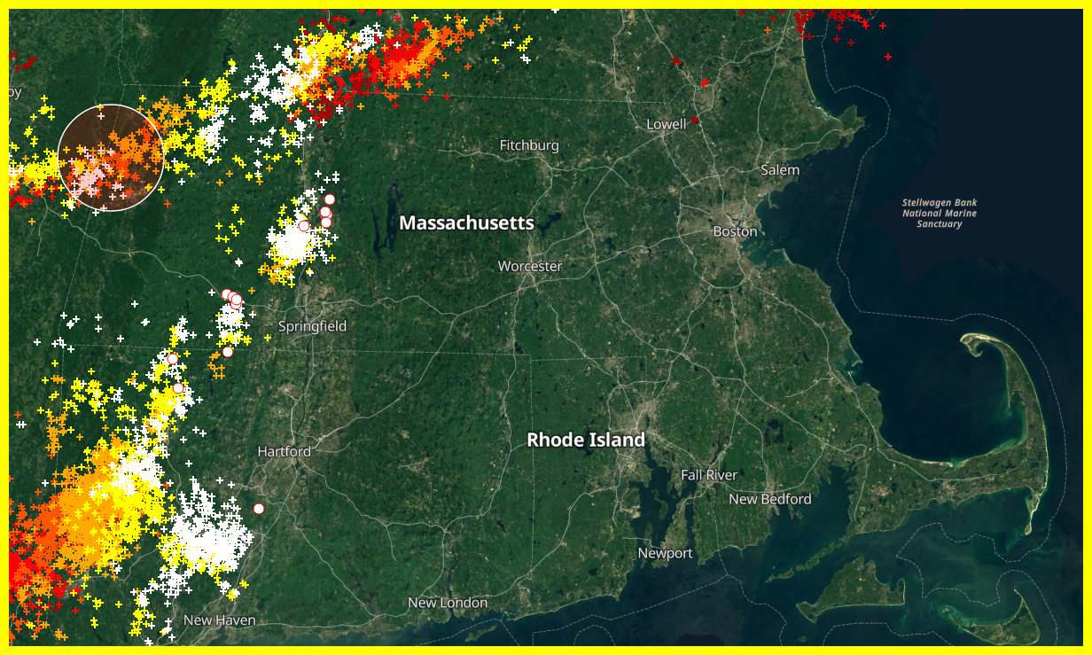
Berkshire County complex is exploding!