

ROOSTA
-
Posts
3,146 -
Joined
-
Last visited
Content Type
Profiles
Blogs
Forums
American Weather
Media Demo
Store
Gallery
Everything posted by ROOSTA
-

The last hurrah? Putting all the eggs in the Tuesday 3/14 basket
ROOSTA replied to Ginx snewx's topic in New England
TIME: Getting close to <48hrs to go time. Sort of running out of model runs. Huge EU run, liking the trends to an offshore more impactful event for Eastern area's. Goalposts have narrowed enough to either your in or your out. Boiling down to the haves and have nots and where? -
The last hurrah? Putting all the eggs in the Tuesday 3/14 basket
ROOSTA replied to Ginx snewx's topic in New England
SREF's (admittedly out-of-range) have a MEAN accum across the landscape much lower than the clown show. -
The last hurrah? Putting all the eggs in the Tuesday 3/14 basket
ROOSTA replied to Ginx snewx's topic in New England
Software available via Unidata. AWIPS and it probably is used by the NWS. I know with GRADS it's just a simple script change in programming, -
The last hurrah? Putting all the eggs in the Tuesday 3/14 basket
ROOSTA replied to Ginx snewx's topic in New England
oh-oh, Mets are playing conservative and for good reason IMHO. The BM track is becoming less likely. Not a perfect capture, stall and stack. Indications leaning toward by the time it does consolidate the SFC center will be at the LAT of BOS, the moisture will have been displaced to the E. so even if the BL cools to support snow it will be of no consequence, also the 40-60mph. gusts from the E toasting the coastal plain. W New England Ctrl NYS parts of the Berks will cash-in on the UL dynamics. Put your horses back in the stalls. This is far from resolved and can change on 6hr intervals. -
The last hurrah? Putting all the eggs in the Tuesday 3/14 basket
ROOSTA replied to Ginx snewx's topic in New England
No dog in the fight really changes the emotional attachment. If you had money on presenting a forecast, I think many would start very conservative most probably wouldn't even comment or forecast. -
The last hurrah? Putting all the eggs in the Tuesday 3/14 basket
ROOSTA replied to Ginx snewx's topic in New England
Many are getting out over their ski's re: The BOX snowfall map? As mentioned, the Agency is where the public turns for Official information and responsible for numerous other Agencies, i.e. Public Works, EMA including the safety of the General Public. It's a First Call Map and way out of range. I'm probably one of few who think it's prudent ATT. -
The last hurrah? Putting all the eggs in the Tuesday 3/14 basket
ROOSTA replied to Ginx snewx's topic in New England
Down to 968 per 18z. -
The last hurrah? Putting all the eggs in the Tuesday 3/14 basket
ROOSTA replied to Ginx snewx's topic in New England
I use to love my boilermakers! -
The last hurrah? Putting all the eggs in the Tuesday 3/14 basket
ROOSTA replied to Ginx snewx's topic in New England
How can it go wrong? One should never base a forecast on the NAM in this type of set-up beyond 2days. -
The last hurrah? Putting all the eggs in the Tuesday 3/14 basket
ROOSTA replied to Ginx snewx's topic in New England
Inside of 24hrs? Thermal profile. Used in warm season for QPF and timing. -
The last hurrah? Putting all the eggs in the Tuesday 3/14 basket
ROOSTA replied to Ginx snewx's topic in New England
Welcome to the show! -
The last hurrah? Putting all the eggs in the Tuesday 3/14 basket
ROOSTA replied to Ginx snewx's topic in New England
What is known, what is unknown? Keepin it real... personal reflect goes a long way. Ironing out QPF, translating to ratios won't be known till. I use the meso's (when in range) heavily on the SREF plume MEAN to pinpoint amounts. -
The last hurrah? Putting all the eggs in the Tuesday 3/14 basket
ROOSTA replied to Ginx snewx's topic in New England
IT'S THE NAM... Not A Model, especially for winter type storms. -
The last hurrah? Putting all the eggs in the Tuesday 3/14 basket
ROOSTA replied to Ginx snewx's topic in New England
Using words as: Possible, First Call, At this time, Subject to change. Will quiet the naysayers. It's a tough field when 99% of the populous have no idea what it entails. -
The last hurrah? Putting all the eggs in the Tuesday 3/14 basket
ROOSTA replied to Ginx snewx's topic in New England
Might start hearing the coveted B word. As it occludes it is a warm core Winter Hurricane. -
The last hurrah? Putting all the eggs in the Tuesday 3/14 basket
ROOSTA replied to Ginx snewx's topic in New England
The CONUS WV shows the ULL system in real-time. Compare where the models initialize that will give a good indication of how, what but won't answer to where. -
The last hurrah? Putting all the eggs in the Tuesday 3/14 basket
ROOSTA replied to Ginx snewx's topic in New England
A fantastic explanation. Much appreciated John. Thank-you If members just read your posts they could learn meteorology without even taking a course. -
The last hurrah? Putting all the eggs in the Tuesday 3/14 basket
ROOSTA replied to Ginx snewx's topic in New England
HOLD ON TO YOUR WEENIES! Nothing resolved, well maybe only a huge storm is about to befall y'all. Complexities of which might just come down to the dreaded "nowcast" Time just flies by. I sit and then look at the time. I thought is was like 10am. FASCINATING! -
The last hurrah? Putting all the eggs in the Tuesday 3/14 basket
ROOSTA replied to Ginx snewx's topic in New England
oops 976 I make mistakes like that all the time. Geez 776 would be end-of-days. Carry-on, my bad. -
The last hurrah? Putting all the eggs in the Tuesday 3/14 basket
ROOSTA replied to Ginx snewx's topic in New England
Not by the models, and far from wish-casting. 970-980Mb is a good ballpark figure. -
The last hurrah? Putting all the eggs in the Tuesday 3/14 basket
ROOSTA replied to Ginx snewx's topic in New England
Yes. I'm really rooting for you guys. Just don't see it playing out as most are portraying. Subject to changing my mind. he-he-he -
The last hurrah? Putting all the eggs in the Tuesday 3/14 basket
ROOSTA replied to Ginx snewx's topic in New England
It is what it is. At the height of the storm SFC temperatures are marginal at best. I have no idea where or why I'm "downing" this. Playing devil's advocate to a possible solution.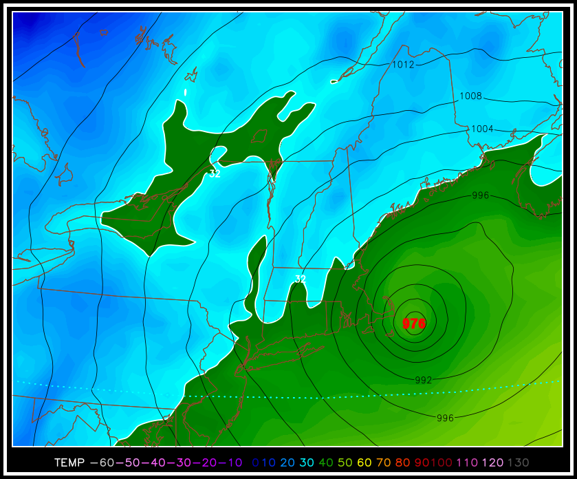
-
The last hurrah? Putting all the eggs in the Tuesday 3/14 basket
ROOSTA replied to Ginx snewx's topic in New England
Locations along the E MA. coast (CC) @100MPH in GUSTS. Still thinking ORH south and east will be toast. A 30 burger just over in NY State. -
The last hurrah? Putting all the eggs in the Tuesday 3/14 basket
ROOSTA replied to Ginx snewx's topic in New England
Still a little convoluted in model land for snow amounts, to many variables still need to be iron out. The prolific 3' amounts are rare even in perfect conditions in the depth of mid-winter. Based on 06z the track is NOT near the BM, the projected stall and capture will more than likely produce a dry slot into E areas. Expect marine taint well inland maybe as far as the Berks keeping QPF way down. Fronto magic will deliver the goods well N and W further than the models are currently producing. Given the marginal airmass elevation will help. Expect random snow-falling in one location and drizzle, light rain next town over, back and forth. By the time the storm matures it's to late the column will cool most in the southern 3 states will be left with light left over snows. I think many are in for a disappointment! Like we haven't seen this before. -
The last hurrah? Putting all the eggs in the Tuesday 3/14 basket
ROOSTA replied to Ginx snewx's topic in New England
Still a long way to go until this gets resolved! I don't trust anything the OP's are running out and will be far from what actually happens. A friigin butterfly could fart in Idaho and change the overall pattern, timing and evolution. It's not like A+B-C*D/F=Z


