

ROOSTA
-
Posts
3,146 -
Joined
-
Last visited
Content Type
Profiles
Blogs
Forums
American Weather
Media Demo
Store
Gallery
Everything posted by ROOSTA
-

1/9-1/10 Now Morphing to Less-Than-Exciting Power Cutter
ROOSTA replied to Torch Tiger's topic in New England
Expecting Power outage this evening. My grid is so fragile a butterfly could just think of farting and out she goes. SPC is a little busy today. -
The southern tail on this is packing a punch. Severe Warnings are being issued all around down here. Gusts in the 40mph. range with temps in the 80's.
-
I was hacked bigtime. My tracking curtailed to the dark ages. Two computers down after installing WhatsApp. Beware of Walware, went right to my OS boot. Good luck all you weenies! Looking good after 2 yr. hiatus.
-
Appears knowledge of micro-climate of SNE, climatology re:, structure of how the storm evolves, temp profile, intensity but most importantly the track will determine how much and what type of precipitation will fall. Thinking CF will be a given. To early to determine jacks. Guess I just encapsulated the purpose of the forum. Everyone should keep expectations in check. No control over the event so emotional expression should be kept at a minimum. IMBY- nobody gives a rats arse.
-
Foreplay arousal, WOOD inbound. She's more beautiful than initially thought.
-
From the trends I 'm thinking fringe effect in SNE. It's a Jersey, Mid-Atlantic event. Still time to change thoughts with the evolving model runs.
-
There is some serious stuff going on in here. DON'T MESS WITH "MY" SNOW! There are so many other events, endeavors in life to get upset about other than the weather. I don't frequent this forum or participate like I used to. I hear a murmur of clapping in the background. 2 years without a solid event brings out the best in people. NOT
-
I think they now have soundings on the ECMWF homepage.
-
Geez it sure busy in this here Forum. Lovin it cause it keeps me grounded to my roots. I've been running the Cave program on one of my computers. Interesting software and looks very detailed, with lots to learn. My worthless obligatory snow maps will be forthcoming closer in to go time. I don't want anyone to hold their breath.
-
Told everyone it was going to snow this year! HAPPY NEW YEAR! One and all.
-
Something to track, FINALLY!
-
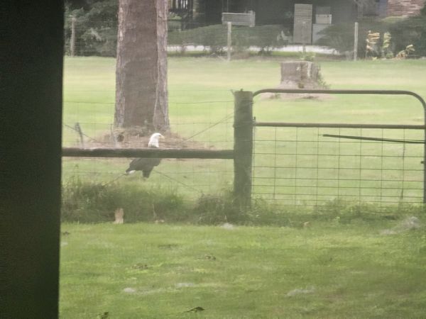
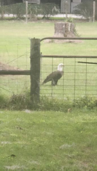
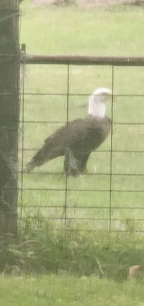
Just your average typical American Bald Eagle walking around the backyard. I hope he was scoping for a nesting area. A guarantee: IT'S GOING TO SNOW NEXT YEAR
-
HAPPY HOLIDAYS!!!! To one and all. I pray that you'll enjoy the Season and the days are filled with memories!
-
Famous last words, (coming from me) The times are a changing. You's guys are going to get some snow with the turn of the year. Ensembles will get the goods percolating. Operational models will come around. Come back in week all will change.
-
I just came across the ECMWF website has expanded the charts with more variables on their HIRES models. Good stuff! https://charts.ecmwf.int/
-
Sunday, December 17 - Monday, December 18, 2023 Storm
ROOSTA replied to weatherwiz's topic in New England
Whoa. More impactful than a tropical system. Not surprised, always had the potential to overachieve. Hoping it's the event to change the pattern going forth. -
Sunday, December 17 - Monday, December 18, 2023 Storm
ROOSTA replied to weatherwiz's topic in New England
The good is just coming ashore. Already have 2.14" in the bucket, winds sustained 15-20, with gusts around 30mph. Temp has been rising with Bar dropping like a rock. WEEEEEEEEE -
Sunday, December 17 - Monday, December 18, 2023 Storm
ROOSTA replied to weatherwiz's topic in New England
I commend you Paul on an excellent write-up. It's going to be wild down here tonight. There are no watch's or warnings yet, should be forthcoming from the SPC and NWS. Impacts will be stronger in many ways than a tropic system. Roosta's WX Command Ctr. is up and running. LOL -
Down here the hype is over-the-top, even took lead in story instead of all the murders. Decorations taken down; local festivities cancelled. Severe threat tomorrow night is heightening. An OCM just stated either zero or widespread activity. Just too difficult to predict, WHAT? One thing for sure Gales with 2-3." A great sign. Just needing the hounds to release. Could be a challenge forecasting several phasing events.
-
I remember that night as if it were yesterday. My Dad just passed, relocated in Florida a month later. My last night on the town. Tumultuous times and missed out on the greatest stretch of Winter weather ever and may never see the likes again. I miss you's guys.
-
A good sign with these systems modelled to "PHASE" going forward it possibly has a bomb or two in Jan.-Mar. '93' without a cold airmass. This present event still has a way to go to resolve. Where it forms, track and timing will be critical to what happens around my environs. Intrigue is back. Feels good to be tracking.
-
The year: 2014 My last GTG. I parked right at the front door, well worth the $50.00 parking ticket. I was just up visiting family for Thanksgiving. Nephew, nieces children about 2 dozen. They grow so fast, half of which I don't even know their names. Anywho... Think it was I who suggested a gathering for those who worked in town. Glad to see it blossom into an annual event. Make it happen!
-
NEXT... So close but no cigar. A stiff breeze 20-30mph sustained along coastal areas, some gusts to >50. A little rain, the bands have already detached, moving well to the N and E. Unfortunately no investment dividend. 10D tracking with only 6-8hrs of blah. Wave action, good photo op will probably be the only redeeming aspect.
-
OT I'm stoked for the longest time I've had a commercial tower 30' in height waiting for erecting. Finally finding a little strength to try. The sections are out at the plot, sensors connected, 200ft to the nearest tree. A wireless Davis VP2, all the whistles and bells. Going to be tough raising @300lbs. The old me would of had it up and running in about 2 days. I also have (4) IP cameras to install for a panoramic view NW,SW, SE, NE. To appease my addiction and yet still haven't found my fix. Two sensor suites, one in each pasture! Lee LF: Rockland ME. Is it really going to be a landfall? Probably be PT as the center of the storm tracks over land. O/U Highest gust: 85mph. In or around Halifax.
-
Throughout the whole evolution of LEE the Global models for the most part have been spot-on with the track. Intensity (expected) hiccuped a couple of times. Back 8 days ago the a pole-ward track would commence , location of the hurricane approx. at 25N 65W. Well modeled! Divergence persists. Here we are...pick your poison, the slower movement especially as LAT is gained should concern everyone. A wobble one way or the other, HUGE If that W' ward hook continues on future runs. RUT-ROH (Ginx) I remember NOEL. Many of us chased down to Chatham, that was fun...


