ROOSTA
-
Posts
3,146 -
Joined
-
Last visited
Content Type
Profiles
Blogs
Forums
American Weather
Media Demo
Store
Gallery
Everything posted by ROOSTA
-
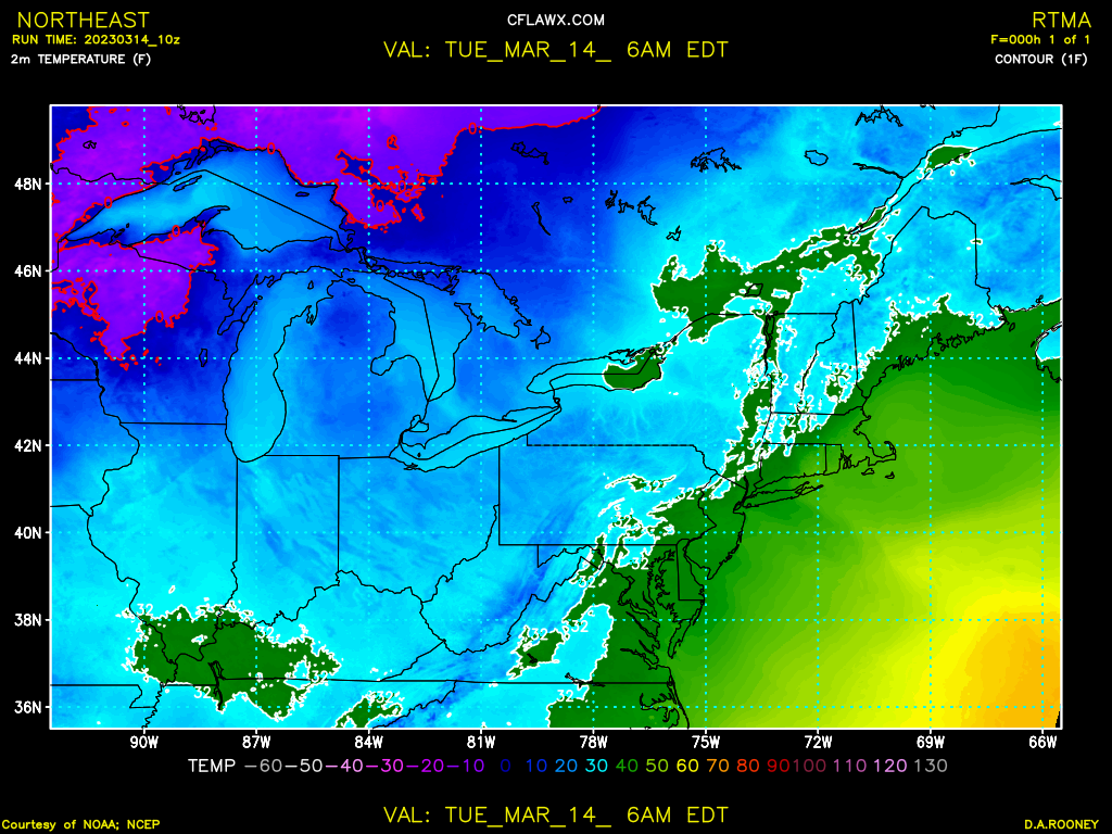
I don't know if these maps I post help. They be an hour behind but they do point out what's going on at the SFC. Ocean influenced E winds into ME. Can see the dual LOW.

-
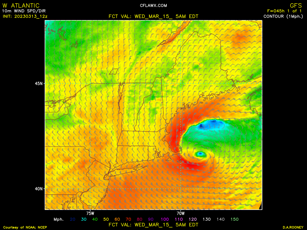
Storm is at @ 993Mb and modelled down to 970 something. Still a ways to go! WOW
-
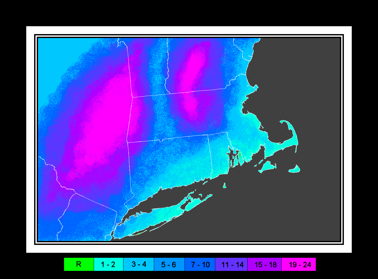
Measuring with a yardstick? Or CT, ruler? Looks like about 24 maybe a little over.
-
I asked jokingly in jest, as a fellow member and friend. One thing I've learned over the years now especially removed 1200 miles is not to become emotionally invested. It's not easy to accomplish.
-
All that matters HAS Methuen FLIPPED YET?
-
CC is steadfast not budging on the W side, with slight movement toward the S on NW periphery. Going to be like watching grass grow for the next hour or two.
-
If you look up marginal airmass you'll find this in the dictonary. Crash baby, crash!
-
If I were back in MA. I'd be going apesh*t. All this wasted QPF! Look a dual- SFC LOW. The Ocean L is starting to explode, take over the circulation. Fear not the change-over will be swift, estimating change to be complete by 12z in the Metro BOS area, 13z in the SS and clear the S coast by 15z. Should go to town tonight for several hours. Est. rates of 2-3"/hr. Smashed potatoes. Accumulation maps are useless- all boils down to obs. and nowcast.
-

The last hurrah? Putting all the eggs in the Tuesday 3/14 basket
ROOSTA replied to Ginx snewx's topic in New England
Ok someone must be on a website that can post a 700 VV map at the height. Guaranteed that (pic) map in this case will tell a story. -
The last hurrah? Putting all the eggs in the Tuesday 3/14 basket
ROOSTA replied to Ginx snewx's topic in New England
Pilot to bombardier: Give me a vector Victor and don't call me Shirley! This is going to be fun watching it unfold. Target insight and it's going to be explosive bomb equipped with an eye and spiral banding. -
The last hurrah? Putting all the eggs in the Tuesday 3/14 basket
ROOSTA replied to Ginx snewx's topic in New England
The actual 5H VORT on satellite WV seems to be slightly S and E of what the 12z models initialized. Getting close to real-time, nowcast analysis. -
The last hurrah? Putting all the eggs in the Tuesday 3/14 basket
ROOSTA replied to Ginx snewx's topic in New England
The RAP does give the Dacks 4FEET! Ya thats going to happen!!! -
The last hurrah? Putting all the eggs in the Tuesday 3/14 basket
ROOSTA replied to Ginx snewx's topic in New England
Things that are going to occur. I think the winds along the E coast will approach Storm Force 12z NAM
-
The last hurrah? Putting all the eggs in the Tuesday 3/14 basket
ROOSTA replied to Ginx snewx's topic in New England
With that 12z HRRR you could overlay a Topo Map almost an exact match Meanwhile I'm 80F with a Td of 72F. Stiff SW winds 20-30mph, with gusts Oh and a threat of Thunderstorms. I've lost my emotional attachment. -
The last hurrah? Putting all the eggs in the Tuesday 3/14 basket
ROOSTA replied to Ginx snewx's topic in New England
Do not look at 12z HRRR. There are some 3' amounts in them their Hills of W Ma. A thing of beauty! Two feet or Bust! -
The last hurrah? Putting all the eggs in the Tuesday 3/14 basket
ROOSTA replied to Ginx snewx's topic in New England
The BUST potential +/- is larger than any storm as far back as I can remember. Two areas in particular: Ctrl NYS forecast 2' could bust by 2' SE Ma. CC forecast 2" could bust by 2' Today's War Cry "2' or BUST" All together now... -
The last hurrah? Putting all the eggs in the Tuesday 3/14 basket
ROOSTA replied to Ginx snewx's topic in New England
QPF lost about 2" across the board. Dumfounded! -
The last hurrah? Putting all the eggs in the Tuesday 3/14 basket
ROOSTA replied to Ginx snewx's topic in New England
Drew Barrymore: "Back-off, back-off. FIRESTARTER There is something wrong with models. Houston We Have A Problem. Each model has a bias and well known but this is ridiculous. Over programmed and overloaded with unseen data? No way to explain... -
The last hurrah? Putting all the eggs in the Tuesday 3/14 basket
ROOSTA replied to Ginx snewx's topic in New England
To be honest I really hate SF maps from the assorted models. It's not representative of the pending changes in model runs. Now a personally drawn map is an individual forecast inclusive of start to finish. With that said my weenie side results in a possible outcome to this chaos... SUBJECT TO CHANGE Stated days ago, that ORH S and E would get burnt. Probably way off but it's only fun at least for yours truly.
-
The last hurrah? Putting all the eggs in the Tuesday 3/14 basket
ROOSTA replied to Ginx snewx's topic in New England
The more you start TOSSING you'll end-up with nothing. One of these models is (will be) less wrong then another. Million-dollar question, which one? -
The last hurrah? Putting all the eggs in the Tuesday 3/14 basket
ROOSTA replied to Ginx snewx's topic in New England
Some clarity... ummm, back to uh oh ummm... Fog incoming down to vis < 1/8 mile. Ah, just stick with elevation. Cut back amounts. "Everything gonna be alright." -
The last hurrah? Putting all the eggs in the Tuesday 3/14 basket
ROOSTA replied to Ginx snewx's topic in New England
GOOD AWFUL WTF Which is it? Anyone care to elaborate? -
The last hurrah? Putting all the eggs in the Tuesday 3/14 basket
ROOSTA replied to Ginx snewx's topic in New England
I'll compromise (2 1/2) it's just a comment to express a point not exact time, Geez! Anyways from beginning to end, end being sometime Wed. Total accum by 8am. -
The last hurrah? Putting all the eggs in the Tuesday 3/14 basket
ROOSTA replied to Ginx snewx's topic in New England
NWS watch, warnings from BOX are measured in content, seem accurate with wiggle room to upgrade or stay as is for 3D lead-time. -
The last hurrah? Putting all the eggs in the Tuesday 3/14 basket
ROOSTA replied to Ginx snewx's topic in New England
It's all tied to IMBY. The scientific aspect is lost come threat time, wishing doesn't equate to an accurate analysis unfortunately. Weigh the comments by who posts.