
Knoxtron
-
Posts
331 -
Joined
-
Last visited
Content Type
Profiles
Blogs
Forums
American Weather
Media Demo
Store
Gallery
Everything posted by Knoxtron
-
Started snowing last night around 8PM, woke up to a half inch of snow. Currently sleeting at 30.6°
-
Lightly snowing with a good dusting, 30.6° I'll take what I can get
-

January 2023 Medium/Long Range Pattern Discussion Thread
Knoxtron replied to Carvers Gap's topic in Tennessee Valley
Still hoping for a little dusting at elevation on the plateau this Monday, at least this time it's been cold going into the event so maybe more will stick. Little more following that as well out to the 27th Lots of potential....- 923 replies
-
- 5
-

-

-
- warm start
- cold
- (and 4 more)
-
Looks loaded upstream coming off Lake Michigan
-
Pouring snow/sleet for hours but accumulation comes and goes strangley enough. Prob the third 1/2 inch that's accumulated then dissappeared today lol Temps steady 30.4°
-
Most of the snow melted/evaporated away but in the last hour started moderately snowing tiny flakes again, got back to 1/2 inch. Temps steady at 30.7°
-
Stopped snowing around 8, currently have about a 1/2 inch. Hoping the slug of moisture in middle Tennessee will make it here, currently 30.9° and very slowly dropping
-
Yeah about 2100', radar isn't showing much over us even though it's still lightly snowing. Got a good dusting so far!
-
Been pouring snow up here since about 4am, just now starting to accumulate. Some of the heaviest snowfall I've ever seen! 32°
-
NAM still adding to the totals at the end of the run mid day Sat. I am solidly in the blues according to these maps...
-
January 2023 Medium/Long Range Pattern Discussion Thread
Knoxtron replied to Carvers Gap's topic in Tennessee Valley
Really appreciate all of the posts and weather insights from you guys! Looks like its gonna be our first time expericing a (hopefully) good north west flow event since our move last summer. Moved from Knoxville to Bledsoe county, up on one the higher elevation ridges (2100') of the plateau/waldens ridge. Just happens our small ridge rises above the plateau about 500-700' and oriented facing northwest.. maybe im being to hopeful but a private road near the top is called Snowy Hoping for atleast a good dusting! No idea what to expect really haha- 923 replies
-
- 5
-
-
- warm start
- cold
- (and 4 more)
-
been getting snow flurries the last hour or so, 38°
-
Somehow ponds still have a good amount of ice coverage up here, crazy how cold the ground got!
-
Historic Christmas Cold & maybe snow?! Dec 23rd-30th
Knoxtron replied to Wurbus's topic in Tennessee Valley
Finally got above freezing around 10AM yesterday, crazy to think there was a 40° temp change from last Friday to yesterday! -4 to +36 almost feels the same as a 40 to 80 jump Only 114 hours below freezing up on the mountain! -
Historic Christmas Cold & maybe snow?! Dec 23rd-30th
Knoxtron replied to Wurbus's topic in Tennessee Valley
Snowing moderate again, going on hour 4 of snow. Approx 1.5 inches -
Historic Christmas Cold & maybe snow?! Dec 23rd-30th
Knoxtron replied to Wurbus's topic in Tennessee Valley
Been light to moderate snow for the last 45 mins under little to no returns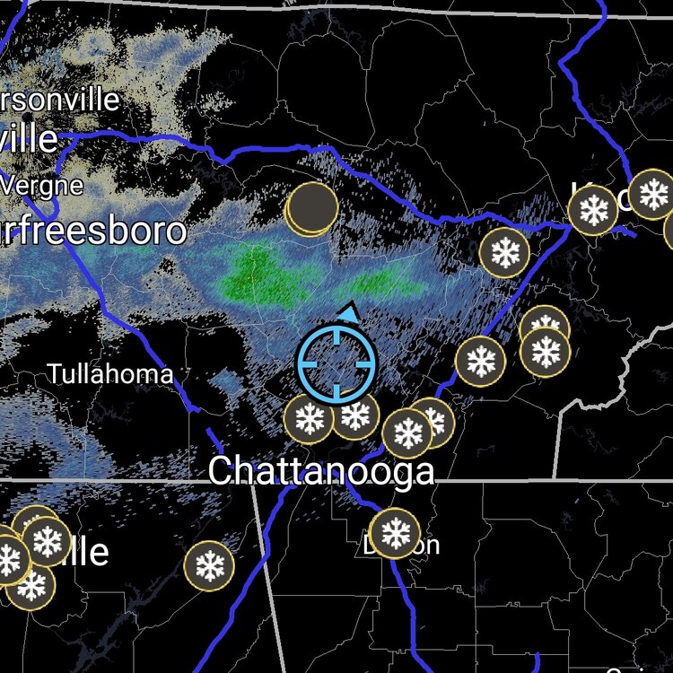
-
Huntsville radar has been down, but appears we've been under decent returns and have been recived only virga on the plateau north of chatt noticed the home weather station has consistenly shown winds from the south all morning, sitting at 21° currently with most of our Friday snow dusting still remaining
-
Historic Christmas Cold & maybe snow?! Dec 23rd-30th
Knoxtron replied to Wurbus's topic in Tennessee Valley
OMG you can actually see the lake effect snow band from Wheeler Lake in Alabama! Curious how much snow that is From yesterday -
Historic Christmas Cold & maybe snow?! Dec 23rd-30th
Knoxtron replied to Wurbus's topic in Tennessee Valley
Looks like TVA has resumed the rolling blackout program, just had Sequatcie Valley Electric Coop turn off my power for a while Got another half inch of snow dust last night, still falling under clear skies. Currently only -1 so only dropped a degree overnight -
Historic Christmas Cold & maybe snow?! Dec 23rd-30th
Knoxtron replied to Wurbus's topic in Tennessee Valley
Appears the lines frozen in two locations We have an outside on demand water heater (supposedly rated for this cold), but I didn't drip thr hot water just cold. Froze right inside the wall The other freeze was where we had a new tub put in against an outside wall, contractor clearly didn't put any insulation back (thermal imager comfirns that). I pit heaters under the crawl space and found the coldest points on my.water lines to put heater blankets and hair dryer. After about 30 mins the hot water started running again -
Historic Christmas Cold & maybe snow?! Dec 23rd-30th
Knoxtron replied to Wurbus's topic in Tennessee Valley
Don't see lake effect streamers from Kentucky Lake very often... -
Historic Christmas Cold & maybe snow?! Dec 23rd-30th
Knoxtron replied to Wurbus's topic in Tennessee Valley
Lesson learned that's for sure! Thankfully I got it unfrozen. I stupidly bought a overpriced FLIR thermal imaging scope a few weeks back... sure came in handy finding the frozen section! I need my wife to see this lol Thanks for the info! Yeah looks like I'm leaving them dripping for a few more days haha -
Historic Christmas Cold & maybe snow?! Dec 23rd-30th
Knoxtron replied to Wurbus's topic in Tennessee Valley
annnnnd our water lines are frozen crap, this isn't gonna be fun -
Historic Christmas Cold & maybe snow?! Dec 23rd-30th
Knoxtron replied to Wurbus's topic in Tennessee Valley
Currently-4° with windchills in the mid -20s, got about half and inch A large 20 acre pond nearby has begun freezing over... so crazy watching the steam rise off the pond like it's a hot cup of coffee! Definitely getting tiny flakes in the air under blue skies, but can clearly see dark gray clouds to the north and west that appear to be convective snow streamers so hopefully get a little more Crazy temp drop overnight! -
Historic Christmas Cold & maybe snow?! Dec 23rd-30th
Knoxtron replied to Wurbus's topic in Tennessee Valley
Front made it up this way 41 at 11:20 24 now and pouring snow, power went out for about 30 seconds but back currently

