CAPE
-
Posts
36,838 -
Joined
-
Last visited
Content Type
Profiles
Blogs
Forums
American Weather
Media Demo
Store
Gallery
Everything posted by CAPE
-
81 at 11pm
-
Let us dream a little, Chuck. Its July 1 lol.
-
I made a poor mans DFH Raison D'Etre by plopping some fresh raisins into a glass and pouring a 90 min IPA over it, giving it swirl, and letting it warm a bit. Pretty good!
-
Not good news, but was not a fan of that signing. He wasn't very good last year- terrible after the trade to the Mets. Os have enough young arms to fill that role.
-
My second team!
-
Os got decent pitching, timely hitting, and didn't have costly defensive/ base running gaffes. Solid game by O'Neill(need way more of that) And they won. Imagine that.
-
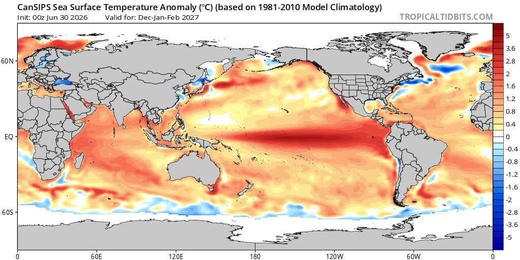
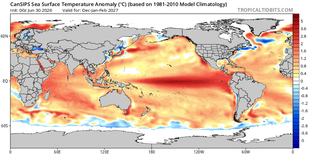
CanSIPS has a basin wide Nino for the winter months. If that verifies the chances for snow vs mostly rain will largely be determined by the HL pattern. As currently advertised the h5 look(+PNA/-EPO/ possibly -AO/NAO should bring some colder air southward at times to combine with a pronounced STJ and some favorable storm tracks. All speculation at this juncture ofc. I will 100% roll with that idea. Anything but a strong East-based event.
-
Highest HI here was 106. Temp now 93 after a high of 95
-
Currently 94/73. That's the high for the day. Feels pretty sultry and miserable out there if you move a little with the high DP. Standing in the shade and not doing anything feels ok for awhile.
-
Its good that you are thinking about these specific and different circumstances. There is rarely one right answer. However, there are agreed upon accepted official standards, both national and international, about how measurements should be carried out, including the specific measurement techniques, calibration, and uncertainty analysis. As someone who teaches metrology, what caught my eye in your OP was questioning why official air temperature is measured in shade(whether it's at a height of 5, 8, or 10 meters is less important). That's what I was focused on. Hopefully you understand that now. Keep up the good work. Always dig deeper for a more profound understanding. There are specific situations that call for some deviation from accepted norms. The context is important.
-
I doubt he will be. He has a partial no trade clause. The logic in doing it is because the team may not be competitive for a few years, and they are going to lose 'core' players to FA, so why not get some younger players via a trade if its to a team Alonso is willing to go to? No idea why you think that hurts their chances to sign future FAs. Its all about the money dude.
-
Approximately lol. I think it has more to do with getting the measurement point reasonably high enough so that heat from near the surface has less influence. My station is probably 4 1/2 feet. Having it in shade is a bigger deal. A radiation shield and proper ventilation can minimize errors when in direct sun.
-
The young core...Adley? He hasn't been good for 2 years now, and injured a lot, Gunnar's play started declining the latter part of last year and he has been pretty awful this season. Mayo? Cowser? Westburg?? Good chance none of them will be on the team in 2 years. The pitching is crap. Its rebuild time dude. Trade Alonso.
-
It wont happen but Elias should be fired NOW. Why let him fuck things up more by making desperate moves before the trade deadline in an attempt to save his job? Why would ownership trust him given what a mess this team has become? This is quickly becoming a dumpster fire.
-
That's good stuff but way overcomplicates it. The simple fact is that the sun doesn't really heat the air- it heats the ground which then transfers the heat to the air by radiation, and it was probably determined that 2 meters was a height where there is significantly less direct influence from retention of heat/ radiation of heat from ground. And again, that height is approximately human head level.
-
The coaching is awful. Gunner is in a total funk, yet they start him every game in the 2 hole. Give him a day off here and there, and move him down in the lineup. He is feeling the pressure and it only exacerbates his struggles.
-
Oh they can, and have. Location! Mostly east of me but there have been plenty of 6-10" events here in Nina winters since 2017. I root for Ninas now. Sure there is always the chance of a ratter with a persistent SER but lately most have been on the cold side.
- 259 replies
-
- 1
-

-
- we got burned
- rugpull central
- (and 1 more)
-
Perfect track rainstorms
- 259 replies
-
- 1
-

-
- we got burned
- rugpull central
- (and 1 more)
-
Sometimes, despite the apparent talent, it just doesn't work collectively. Not aways easy to pin down, and in most cases there are multiple reasons. Look at the Mets the past 2 seasons. Absolute disaster. I think its time to make changes. Make some deals at the deadline but more for the future, not necessarily to try to win now. Trade Alonso. Get a couple good younger players, and jettison players like Mayo and Cowser. Busts.
-
@SnowenOutThere Metrology is important(essential) to meteorology. Not sure that it is taught in a meteorology program(probably not), but imo it probably should be. If not, you can get a more profound understanding of some of the questions you seek by learning a bit more about it. Just a suggestion.
-
A few practical things to consider. Fundamentally temperature is a measure of the average(random) atomic kinetic energy of a substance. There is a sensor involved in this measurement- usually a Pt 100 RTD. It produces a predictable change in resistance with a change in temperature. Errors associated with this measurement include self heating(electrical current flowing through the resistance of the sensor = heat). Minor effect. Absorbing solar energy in direct sunlight has a similar effect- but it produces a more significant error(due to sensor heating) while measurement of actual air temperature is the objective. That can't be accomplished in direct sunlight. The 2 meter/in shade 'requirement' allows consistency in the measurement regardless of location. That became the standard. It could have easily been at some other level, but 2 meters off the ground is where we live. One of the topics I teach is temperature measurement for industrial processes- so I am a bit geeky about the topic lol.
-
I'm consistently 'contributory', but you are entitled to your opinion. I won't comment on your value here......................................................... No kicks. I just tell it like it is. And my 'mental issues' have nothing to do with my age.
-
For accuracy measuring the actual temperature, it is important. My station gets "sun soaked" briefly early afternoon this time of year, and I discard those readings.
-
Big heat is kinda boring as a weather event. Just have to deal. Luckily it wont last that long this time.