

CAPE
-
Posts
36,838 -
Joined
-
Last visited
Content Type
Profiles
Blogs
Forums
American Weather
Media Demo
Store
Gallery
Everything posted by CAPE
-
For those interested in actual science- https://www.climate.us/
-
-
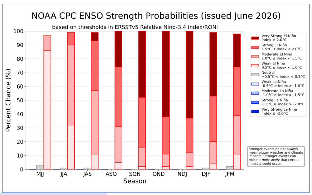
"Super" is hyperbolic. Just like monstrous, Ludicrous, or 'Godzilla' Nino. Social media silliness. Official categories for strength of Nina/Nino events are- weak, moderate, strong , and very strong.
-
Picked up a few hundreds overnight to push the total to 1.02". Hopefully more to come this week.
-
Check the radar now
-
Looks the like ocean/bay breeze boundary is losing its oomph. Those storms will probably weaken and dissipate as they did over here. Need another trigger.
-
Interpret it literally- there is an 80% chance you will get some rain- and a 20% chance you won't. Should you get some rain, amounts between a quarter and a half inch are possible.
-
Looks like all the action east of the bay and now just to the west is being triggered by a westward moving boundary from the Ocean/ DE bay.
-
Flood Watch. Over here just to my SW there is a Flash Flood Warning, but no flood watch is in effect. See the difference? Anyway, see how things evolve this evening. It will not be widespread- almost never is in these setups- but decent chance places within the watch area will need a flash flood warning.
-
Breeze off the DE bay doing some work over here triggering heavy rain in the area, but not in my yard at this point lol.
-
Sitting at 0.95" here. With the extreme drought and given the near ideal setup for heavy rain, anything less than another half to one inch would be disappointing.
-
Looks like @SnowtoRain might get crushed again
-
GEFS and GEPS keep the ridge out west and have average to even slightly below avg temps. EPS expands/shifts it towards the central US, but temps in the east look pretty typical for mid July.
-
0.83" so far
-
Nothing heavy but yeah some persistent showers. Much heavier to the south.
-
Booming thunder and legit heavy rain just woke me up. Finally something decent.
-
Already north although there is another appendage developing just to the SW. See what that does.
-
0.21" Need 10 times that over the next couple days to put a dent is this drought.
-
Some nice cracks of thunder and a decent downpour. Won't last long but at least on the board.
-
Hopefully. That graphic looked very similar for last evening and yielded next to nothing for many.
-
Got some action developing along a boundary moving westward from the ocean/DE bay. A cell just north and more developing just south(typical lol) Looking like some northward movement. We shall see. Hearing thunder now.
-
-
-
Radar looks exactly like the last time we had a multi-day threat and I ended up with less than a tenth total- action going north, action going south and nothing happening in between lol. Comical at this point. Maybe tomorrow, or the next day will deliver Might get some leftover sprinkles later as the stuff west of DC dies off moving east. Still low key kind of rooting for exceptional drought category. Why not at this point? 92 and gross outside.
-


