

CAPE
-
Posts
36,838 -
Joined
-
Last visited
Content Type
Profiles
Blogs
Forums
American Weather
Media Demo
Store
Gallery
Everything posted by CAPE
-
Looks like some hail near Ridgely. Already 0.42" there. 0.23" here.
-
I think you are getting crushed dude. Probably an inch at least.
-
You are gonna get nailed pretty good by the looks of it. Bowing segment with some hail per radar.
-
Booming thunder. Looks like Ridgely 3 miles to my SW will get hit pretty good. Be interesting to compare the Mesonet site there to my station lol. Looks like I should see at least some moderate rain.
-
I need that convection to build a bit further north as it heads east. Probably unlikely.
-
I am further north. NW of Greensboro. Hearing some nice thunder from the storm just missing to my south! Broken record since April.
-
Disintegrating on the doorstep lol. Same old. Perhaps a sprinkle or some drizzle. What a horrific forecast from Mount Holly this morning. 1-2" lol. You would think in situations like this they would just go with the standard 'tenth of an inch or less except in thunderstorms' wording. The activity upstream is gonna crush areas south of here. Probably comes down to tomorrow, which also favors areas just south. Low key rooting for exceptional drought category at this point lol. I have never seen that here before.
-
Some nice cracks of thunder to the west. Looks like the goods will go south but its close. Hopefully I can get some scraps of moderate rain with this batch. See how it goes with the stuff further west later.
-
I saw dust devils a little earlier in the field(with crops) across from my driveway.
-
Mid shore is gonna get it, but north of you and probably south of me. Congrats Denton.
-
Looks good in general, but I can see the split lol. See how it evolves.
-
This morning Mount Holly actually had 1-2" in the forecast here for tonight, with a quarter to a half inch today. I knew that forecast was a bust. Now a half to three quarters tonight, and pretty much nothing this afternoon/early evening. See what it gives. There's always the delayed but not denied thing for tomorrow if tonight underwhelms with another piece of energy slowing the front. I'm sure it will all work out.
-
That really sucks for the areas that really need it. Luckily, the NAM really sucks lol.
-
Forecast here is for 0.75" to 1.25" for Monday/Monday night. I have seen that sort of thing multiple times over the past few weeks, only to get next to nothing. I will believe it when I see it lol.
-
Steady heavy rain up north and hit or miss storms around here. That will be frustrating as usual.
-
The 35-41 orioles, who were just shutout despite a good pitching performance, now get to play the Dodgers lol. Any chance this ends well?
-
Is it bad that I am already sipping on a bourbon?
-
It is a bit yes. I mean it could happen, but heavy snows in the deep south?? Even northern Florida? that's just ridiculous. Even more so in a strong El-Nino winter. Sure it will be cooler than normal and generally wet there, but not white.
-
The water table barely broke the surface in my seasonal woodland wetland this Spring. Just some patches of "puddles" here and there. Normally it ends up an expansive area(an acre) of water a foot deep. Applying larvicide was an easy job.
-
Per Mesonet the VWC is 0.02 at the Ridgely station. Probably about the same in my yard.
-
We miss to the NW one day, and to the SE the next. At least the lower shore and SE DE will get a tiny bit of relief from the drought.
-
Its ridiculous. Tree debris all over the place here. A high velocity hot blowtorch that's just exacerbating the drought.
-
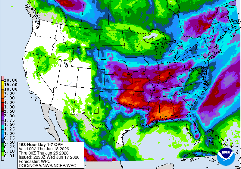
Extreme drought over here per latest update. Cant buy a raindrop.
-
Comical
- 259 replies
-
- 3
-

-

-

-
- we got burned
- rugpull central
- (and 1 more)
-
Sure. But I can still look forward to Fall. Summer sucks if its going to be a veritable desert.


