
CAPE
-
Posts
36,647 -
Joined
-
Last visited
Content Type
Profiles
Blogs
Forums
American Weather
Media Demo
Store
Gallery
Everything posted by CAPE
-
 Heh, might actually get something that will make this day not a total bust.
 -
With a voddy tonic. oh, having one now.
-
Well this has largely disappeared lol. Still a bit of a -NAO develops towards the very end of the month. Not very helpful at that point. Still, the currently advertised pattern centered on the 25th isnt awful.
-
It is the best model. One against all the rest.
-
What a complete nothingburger. The decision to close schools early was questionable regardless. I mean, even in a worst case scenario in these parts, we are taking a few tornados over a very broad area. Anyway, a tenth of an inch of rain here lol. Didn't even sniff a garden variety storm and minimal wind with forecasts of 40+ mph gusts. Not mad at all.
-
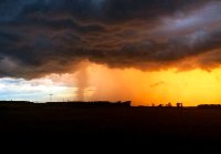
You can get some awesome shots over here as you know with it being flat and wide open. I have so many cool shelf cloud shots. eta-shots like my current profile pic
- 1,093 replies
-
- 1
-

-
- severe
- thunderstorms
- (and 1 more)
-
Depends on the model- The 3km NAM suggest you might want to head east.
-
Sounds like both to me.
-
Idk, seems like we routinely fail at severe. Mostly garden variety storms with some heavy rain, modest wind gusts, and some decent T&L.
- 1,093 replies
-
- 2
-

-
-
- severe
- thunderstorms
- (and 1 more)
-
I probably have at least 50 trees that could reach my house but luckily the only close call(other than some branches) was an oak that fell during Irene. The very top branches barely brushed the back of the house.
-
It's not over, at least potentially... if the NA look materializes and we can time a wave.
-
This potential severe outbreak has inspired a profile pic change from Winter to Spring mode. I think I took that one back in 2015 from the end of my driveway. I will be driving from work northeastward towards home late afternoon tomorrow. I may adjust the timing based on actual conditions.
- 1,093 replies
-
- 3
-
-
- severe
- thunderstorms
- (and 1 more)
-
Chaser in WI and into MI. https://www.youtube.com/watch?v=dxFBUJmARtU
-
https://www.news8000.com/weather/live-cameras/
-
SPC ...Carolinas into MD/PA and vicinity... Areas of showers may occur early in the day especially but should rapidly lift north, allowing areas of heating and gradual destabilization over the entire area. As the surface trough deepens, low-level wind will back and strengthen throughout the day. Supercells producing tornadoes appear most likely ahead of the cold front from SC into NC and southern VA. Models vary with degree of instability, but strong tornadoes do appear possible with effective SRH of at least 300-400 m2/s2. Fast storm motions over 50 kt suggest a long tracked tornado will be possible. Meanwhile, a robust line of storms will develop as the cold front pushes east, stretching from the Carolinas to southern NY. With a moist air mass and large-scale support, this line is expected to produce particularly damaging winds, along with QLCS tornadoes across the remainder of SC/NC, VA, MD, and much of southern PA. This will likely peak during the late afternoon hours. The activity may eventually interact with cool trajectories off the Atlantic during the evening.
- 1,093 replies
-
- 2
-

-
-
- severe
- thunderstorms
- (and 1 more)
-
A couple webcams to monitor the MN-WI-MI blizzard- https://it.nmu.edu/webcam
-
Pacific is kinda crap but that's a legit NAO Rex Block as advertised. In late March, that could work.
-
I was gonna suspend the WB account yesterday but I didn't want to rely on WW for maps just in case something unusual happens lol.
-
The Chill WDI remains favorable.
-
I did post an h5 map for that window a couple days ago- I said it was awfully late outside of the mountains, but ya never know. Shit can happen the last week of March, and this might be the winter for it given we have scored multiple times without the 'ideal' upper level pattern.
-
It's very interesting, but the outcome can be devastating in many ways. Its weird- from a weather geek perspective we love it and tend to want it to happen- as long as it occurs elsewhere and not in our yards lol. Morbid.
-
Gunnar not in the lineup tonight for USA vs Canada. WTF? Why is a TV personality even a manager? He has no experience and didn't even know the rules and rested players against Italy. Lucky they made it to the quarterfinals.
-
What do you look forward to from now into late next Fall? Its all we got(plus tropical), which both tend to fail more prolifically than winter weather. That leaves bigtime heat. We do that very well! Embrace it.
-
Yeah just looked at the schedule- April 2026. I will be down there in early April- hopefully I can get it on tap.


