CAPE
-
Posts
36,948 -
Joined
-
Last visited
Content Type
Profiles
Blogs
Forums
American Weather
Media Demo
Store
Gallery
Everything posted by CAPE
-
99.3. If it gets to 99.5 I get to round up, right?
-
99! Never hit 100 since I have been at this here location.
-
98/75 Feels like an oven out there. Not likely gonna get to 100 though.
-
From Mount Holly AFD this morning- DISCUSSION... KEY MESSAGE 1...Dangerous heat and humidity will build across the region through Saturday. All time record high temperatures could be challenged today and Friday with widespread triple digit temperatures. Strong mid-level ridging across the Mississippi Valley, Great Lakes, and Ohio Valleys is building eastward into the Northeast and Mid Atlantic and will persist into the holiday weekend. A west to southwest flow will shift more west to northwest by Friday. The ridge will finally start to break and retreat some starting Saturday into Sunday. High temperatures are forecast to range between 100 to 105 degrees in most areas today and Friday. The shift to a more west to northwest flow aloft will allow for better mixing out of dewpoints during the afternoon, and also a component of downsloping (adiabatic warming) from the Appalachians. This phenomenon should be a little stronger on Friday with low level flow being slightly stronger, but regardless dewpoint should still mix out a fair amount this afternoon. This setup will support temperatures climbing above 100 degrees across most non mountainous inland areas as dewpoints mix out into the mid to upper 60s during the afternoon hours. Resulting forecast heat indices are mostly in the 105-110 degree range, though localized values upwards of 115 degrees are possible if dewpoints stay closer to 70 degrees. This is indeed the type of synoptic pattern that could challenge all time record high temperatures in our region. Areas north of I-78 are forecast to experience the hottest air temperatures (upper 90s to near 100 degrees, even as high as 95 degrees at Mount Pocono) today. Further south, the hottest air temperatures (mainly in the 100-105 degree range, and in the upper 90s to near 100 degrees for the New Jersey Shore and Delaware Beaches) are forecast to occur on Friday.
-
He is young and has been handled terribly, so still some hope if the ownership has the balls to clean house at the top. New GM. New manager, and coaches. Hard to say which of those is worse right now, but its all bad and major change is needed.
-
Imo, not until Elias is gone. I wish that could be now, but ofc it won't be. So he will likely make some moves at the deadline that will further set this team back in an attempt save his skin, then get canned after the season.
-
Well lets be honest about this team- there are a lot of uncertainties at this point-unless you believe the Elias gaslighting lol.
-
Same. And wasting time bantering about the Orioles lol. Bring on training camp!
-
Nice first post. The Orioles signed Alonso with the idea that they would be in contention and he could be a piece to help put them over the top. As it turns out, that doesn't appear to be working out. He would have to be willing to be traded, but lets say he is. Maybe after being a member of the disastrous Mets last year, he now sees a similar situation here at this point. Given how disappointing the Orioles have been for the better part of 2 seasons, the lack of progression of several of their core players, and the likely prospect of losing some of them to FA in the next 2-3 years, why is this so far fetched? Trade a vet to a contender, dump some salary, get a couple good young players in return. Will it happen? Most likely not.
-
All teams are trying to win. If by "trying to win" you mean "in contention" are the orioles really that? Now might be a good time to see if they have a closer in the making. That guy was at best a stop gap, and a pretty expensive one at that.
-
81 at 11pm
-
Let us dream a little, Chuck. Its July 1 lol.
-
I made a poor mans DFH Raison D'Etre by plopping some fresh raisins into a glass and pouring a 90 min IPA over it, giving it swirl, and letting it warm a bit. Pretty good!
-
Not good news, but was not a fan of that signing. He wasn't very good last year- terrible after the trade to the Mets. Os have enough young arms to fill that role.
-
My second team!
-
Os got decent pitching, timely hitting, and didn't have costly defensive/ base running gaffes. Solid game by O'Neill(need way more of that) And they won. Imagine that.
-
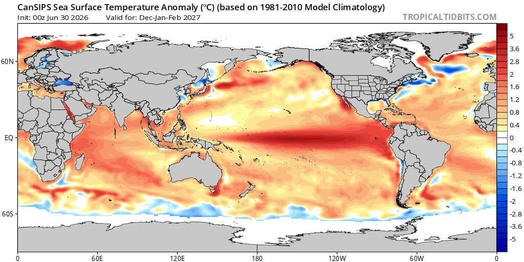
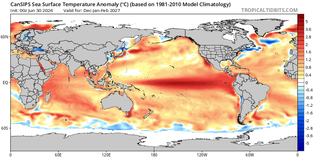
CanSIPS has a basin wide Nino for the winter months. If that verifies the chances for snow vs mostly rain will largely be determined by the HL pattern. As currently advertised the h5 look(+PNA/-EPO/ possibly -AO/NAO should bring some colder air southward at times to combine with a pronounced STJ and some favorable storm tracks. All speculation at this juncture ofc. I will 100% roll with that idea. Anything but a strong East-based event.
-
Highest HI here was 106. Temp now 93 after a high of 95
-
Currently 94/73. That's the high for the day. Feels pretty sultry and miserable out there if you move a little with the high DP. Standing in the shade and not doing anything feels ok for awhile.
-
Its good that you are thinking about these specific and different circumstances. There is rarely one right answer. However, there are agreed upon accepted official standards, both national and international, about how measurements should be carried out, including the specific measurement techniques, calibration, and uncertainty analysis. As someone who teaches metrology, what caught my eye in your OP was questioning why official air temperature is measured in shade(whether it's at a height of 5, 8, or 10 meters is less important). That's what I was focused on. Hopefully you understand that now. Keep up the good work. Always dig deeper for a more profound understanding. There are specific situations that call for some deviation from accepted norms. The context is important.
-
I doubt he will be. He has a partial no trade clause. The logic in doing it is because the team may not be competitive for a few years, and they are going to lose 'core' players to FA, so why not get some younger players via a trade if its to a team Alonso is willing to go to? No idea why you think that hurts their chances to sign future FAs. Its all about the money dude.
-
Approximately lol. I think it has more to do with getting the measurement point reasonably high enough so that heat from near the surface has less influence. My station is probably 4 1/2 feet. Having it in shade is a bigger deal. A radiation shield and proper ventilation can minimize errors when in direct sun.
-
The young core...Adley? He hasn't been good for 2 years now, and injured a lot, Gunnar's play started declining the latter part of last year and he has been pretty awful this season. Mayo? Cowser? Westburg?? Good chance none of them will be on the team in 2 years. The pitching is crap. Its rebuild time dude. Trade Alonso.
-
It wont happen but Elias should be fired NOW. Why let him fuck things up more by making desperate moves before the trade deadline in an attempt to save his job? Why would ownership trust him given what a mess this team has become? This is quickly becoming a dumpster fire.
-
That's good stuff but way overcomplicates it. The simple fact is that the sun doesn't really heat the air- it heats the ground which then transfers the heat to the air by radiation, and it was probably determined that 2 meters was a height where there is significantly less direct influence from retention of heat/ radiation of heat from ground. And again, that height is approximately human head level.