All Activity
- Past hour
-
Tropical Storm Henriette Discussion Number 18 NWS Central Pacific Hurricane Center Honolulu HI EP082025 Issued by NWS National Hurricane Center Miami FL 500 AM HST Fri Aug 08 2025 Henriette has failed to produce deep convection for about 12 hours now. The latest subjective Dvorak estimates are 25 kt from JTWC and too weak to classify from SAB and PHFO. Recent objective intensity estimates range from 25 to 40 kt. An earlier ASCAT pass from 0535 UTC showed a large area of 30-33 kt vectors on the north side of Henriette. Henriette will be maintained as a 35-kt tropical storm for this advisory, but it could degenerate to a post-tropical remnant low at any time today. The cyclone is moving just north of due west at 280/15 kt. A turn to the west-northwest is expected soon as the cyclone tracks along the southwestern periphery of a subtropical ridge to its northeast. A turn toward the northwest is forecast late this weekend into early next week as Henriette becomes steered between an amplifying longwave trough northwest of Hawaii and the subtropical ridge to its northeast. The NHC track forecast is nearly identical to the previous one and is in good agreement with the tightly clustered consensus aids. Confidence remains high that Henriette will remain far to the north of Hawaii. Henriette is over 24C sea-surface temperatures (SSTs) and is embedded within a dry airmass. These cold SSTs are expected to persist along the cyclone's track for another 12 to 24 h. If Henriette doesn't generate organized convection soon, it could degenerate to a remnant low today, and this is explicitly shown in the NHC forecast Beyond 24 h, Henriette (or its remnants) will encounter progressively warmer water temperatures over the weekend, peaking around 26-27C in about 3 days. Upper-level temperatures are also expected to decrease in a couple of days as the aforementioned trough approaches Henriette, which would increase instability. These factors, along with relatively low shear, will likely allow Henriette to restrengthen later this weekend into early next week, as depicted by most of the models. The NHC intensity forecast is at the low end of the guidance envelope through 36 h, and at the high end of the guidance at 72-96 h. Beyond day 4, wind shear from the longwave trough and cooling SSTs should lead to steady weakening as Henriette moves farther into the mid-latitudes. Even if Henriette becomes post-tropical today, given the high likelihood of regeneration back into a tropical cyclone and subsequent restrengthening, NHC plans on maintaining advisories during the post-tropical phase. FORECAST POSITIONS AND MAX WINDS INIT 08/1500Z 19.7N 141.5W 35 KT 40 MPH 12H 09/0000Z 20.3N 143.7W 30 KT 35 MPH...POST-TROP/REMNT LOW 24H 09/1200Z 21.3N 146.3W 30 KT 35 MPH...POST-TROP/REMNT LOW 36H 10/0000Z 22.6N 148.7W 35 KT 40 MPH...TROPICAL CYCLONE 48H 10/1200Z 24.1N 150.9W 45 KT 50 MPH 60H 11/0000Z 25.9N 153.2W 55 KT 65 MPH 72H 11/1200Z 27.9N 155.7W 65 KT 75 MPH 96H 12/1200Z 32.3N 160.4W 65 KT 75 MPH 120H 13/1200Z 37.1N 165.1W 50 KT 60 MPH $$ Forecaster Hagen
-
-

Occasional Thoughts on Climate Change
TheClimateChanger replied to donsutherland1's topic in Climate Change
-
I mentioned how the shadows looked funky with the smoke.
-

2025 Atlantic Hurricane Season
BarryStantonGBP replied to BarryStantonGBP's topic in Tropical Headquarters
-
WELCOME ABOARD INVEST 96L (0/50)
BarryStantonGBP replied to BarryStantonGBP's topic in Tropical Headquarters
-
TROPICAL WAVE LOCATED IN CHAD, AFRICA (NOT 96L)
BarryStantonGBP replied to BarryStantonGBP's topic in Tropical Headquarters
-
air quality alert for smoke issued for the entire eastern panhandle of WV.
-
how dare you get told that molotov cocktails are dangerous
-
July 2025 Discussion-OBS - seasonable summer variability
TheClimateChanger replied to wdrag's topic in New York City Metro
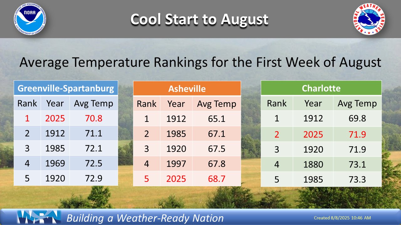
Pretty close! Officially checked in at 71.9F, matching 1901 & 1949 for 4th place overall. -
Interesting @Kmlwx https://x.com/Gio_wx/status/1953625408219271370
-
Looking at 850Ts, seems like a subtle shift north with the highest 850 temps on guidance. Might be your classic MHT-lower elevation Maine roaster. Just for Dryslot. A Tamarack Torcher.
-
 NYC came extremely close to having three days of 100+ which is outrageous in this era of foliage blockage and the fact that this happened in August, not July. It still did not match August 1948's three straight days of 100+ but this was the closest we've gotten to since then for three straight 100+ days at NYC in August. Tony could you post the 100+ days in August 1948 at all of these locations please-- I think this was the first month that the sensor at JFK came into operation.
 -
If the Coop is nearby, it's over 400' lower. So makes sense it would be warmer.
-

2025-2026 ENSO
40/70 Benchmark replied to 40/70 Benchmark's topic in Weather Forecasting and Discussion
I understand the limitations of these data at this range, but I don't disagree. -

2025 Spring/Summer Mountain Thread
Maggie Valley Steve replied to Maggie Valley Steve's topic in Southeastern States
What an amazing start to August!
-
Yes, you are right. Looks like the NWS must have a coop site nearby too. Looks a little warmer throughout the record than the observatory numbers, maybe lower in elevation?
-
what I find ironic is that JFK's 99 was actually on the day prior to the hottest day in the other locations. LGA and EWR set the monthly records with their 104 and 105 and NYC was only one degree off with their 103.
-
Thanks Tony!! Wow, the skies are so deep blue, I could live with this weather forever. Screw summer, screw winter, just have this weather 24/7/365 lol
-
Not sure if the Coop is the same as the observatory. I read it off their website.
-
Blue Hill Co-op saw its 4th hottest July on record with a mean temperature of 75.4F. Overall, it was the 9th hottest July for the state of Massachusetts with a gridded mean of 73.7F.
-
No smoke, no humidity. Just a 10/10 day out there.
-

2025 Atlantic Hurricane Season
WxWatcher007 replied to BarryStantonGBP's topic in Tropical Headquarters
I can't imagine the NHC will wait too much longer before tagging the newest wave given the signal across guidance, but with 96L "underperforming" (great call @Newman) we see how a model signal can change on a dime in this environment. -
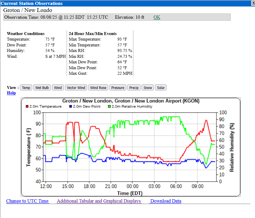
Hmm...KGON seems to be having some sensor problems. Hit 91 yesterday and 93 already today.
-
Agree about "significant uptick" but the subseasonal environment is getting more favorable. And if you're the kind of person looking for land impacts you probably want only one game in town--or at least widely spaced systems--otherwise you'll likely end up with ridging weaknesses all over for easy recurves. My current thought is that 96L underperforming may actually open the door for a closer approach of the follow up wave because the weakness in the ridging that is going to take 96L away will have the ability to close before the wave leaving Africa can reach it.