All Activity
- Past hour
-
A nice couple of days on tap across the area with highs reaching up into the low 80's today and the mid 80's tomorrow. Tomorrow should be the warmest day of the week before we cool back to near normal with shower chances increasing by Friday night into Saturday.
-

E PA/NJ/DE Summer 2025 Obs/Discussion
ChescoWx replied to Hurricane Agnes's topic in Philadelphia Region
A nice couple of days on tap across the area with highs reaching up into the low 80's today and the mid 80's tomorrow. Tomorrow should be the warmest day of the week before we cool back to near normal with shower chances increasing by Friday night into Saturday.
-
On the 7th I'll toss up a CF6 for the first 7 days at KEWR.... whose data seems hot to some of us but likely is not per NWS tolerances for ASOS Data. Whether we can muster 90 this Thu or Fri is doubtful to me (17C 850) and smoke aloft which I suspect is knocking off a deg or 2 on daytime max. Looking ahead 13th-20th first day of summer... I'm taking a stab here but unless compromised by sea breezes or midday showers, looks to me like a pretty long stretch of a above normal temps as Both the EPS and GEFS are developing a significant ridge somewhere between 80 and 95W...Ie Great Lakes-Upper Midwest. That should mean warming here with possible cool frontal passages, but also possible shots at 90F for at least the interior. Have a day
-
Hazy smoke slowly clearing east in NJ
-
yesterday's catching up to us from the past - ... kinda reminds me of the QM stuff about time being in both directions. Like reality explodes out of QM, as an emergence, so ... that's what makes the observation actually possible. Man, that's weird - anyway, an hour ago i cited that we were ahead of yesterday per hour::minute with temperature recovery, but had only recovered 10 - yesterday's delta per was 16... this difference was that initially, today had a 6 or so deg head start, so at the time we were ahead of yesterday. however now, we are the same as yesterday per hour:minute. So today's smoke retarded rising at a slower rate is allowing yesterday to overtake us, winning the race from the past. ... think i need to dump this coffee... so for the time being, and all other factors being equal, that leaves smoke blunting as a high confidence limiting factor. i don't think the models actually factored that in. the NAM/met machine numbers are 87-89-ish along the BDL-FIT-ASH arc ... we may still make that because the complexity of this crushingly nerdy expose is then enhanced further by the fact that machine numbers tend to be too cool on this side of the solar max anyway... so the smoke blunting give the machine numbers at an unfair competitive advantage.
-
Thank God
-
Weekend rain threat really fell apart
-
How did I go my whole life without knowing about this?
-
That is the only feature that I miss from my old house. We used that a lot.
-
on a couple of borderline nights we turned on the whole house fan-sucks the heat right out assuming the outdoors is not humid.
-
https://www.mediaite.com/media/tv/florida-weatherman-warns-he-wont-be-able-to-accurately-predict-hurricanes-this-summer-because-of-federal-budget-cuts/
-
I didn't create it, just sent it out all over the world. 52 for the low here.
-
How is your second floor not hot though? The Sun is so strong that it gets quite warm even if it's like 75 and sunny.
-
73/35 yesterday under blue skies. Moon had a yellowish tone last evening as the smoke arrived.
-
It's been nice-have yet to turn on the CAC here....but it's coming
-
-
What lake are you on?
-
I am pleased with our low this morning. If only every morning can have lows in the upper 50s in summer it would be amazing.
-
He dead
- Today
-
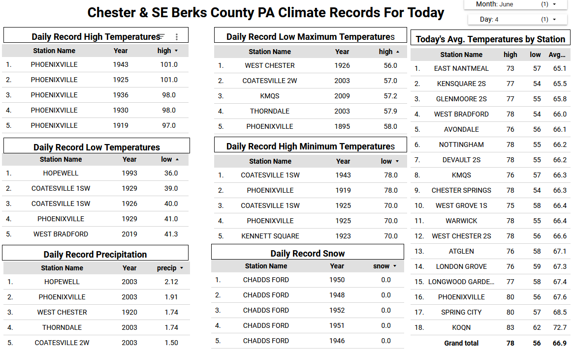
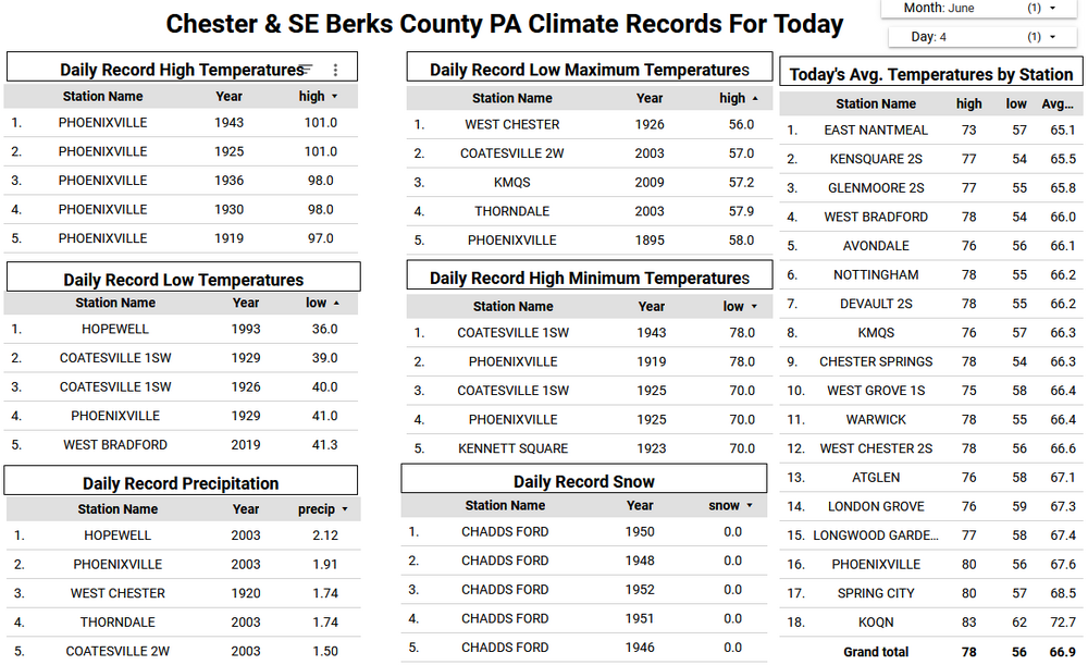
Records: Highs: EWR: 97 (1943) NYC: 99 (1925) LGA: 96 (1943) JFK: 91 (1971) Lows: EWR: 48 (1964) NYC: 48 (1926) LGA: 51 (2023) JFK: 49 (2023) Historical: 1825 - A hurricane struck Long Island NY leveling trees and causing damage to ships. The early season hurricane, which originated around Cuba, caused major damage along the Atlantic coast from Charleston SC to New York City. Many were lost at sea. (David Ludlum) 1825: A severe storm of tropical origin swept up the Atlantic Coast during the first week of June 1825 with reports of significant damage from Florida to New York City. Shipping logs told of a disturbance at Santo Domingo on May 28th and Cuba on June 1st. Gales were reported at St. Augustine, Florida on the 2nd. The Norfolk and Portsmouth Herald reported "undiminished violence" from the gale force winds for 27 hours, ending on June 4th. The effect of the storm reached well inland. Washington had cold, heavy rain all day on the 4th with high winds laying the crops in the vicinity. The wind also tore up trees by the roots in front of the State House in Philadelphia. This storm impacted the New Jersey Coast and the Long Island area as well with high winds and a two-foot storm surge. A Columbian frigate was driven ashore as were many smaller boats. The largest loss of life occurred along the Long Island shore when a schooner capsized. The entire crew of seven was lost. 1860 - Iowa's Commanche Tornado , with wind speeds estimated in excess of 300 mph, was unquestionably one of the worst experienced by early settlers, with nearly a million dollars damage. (The Weather Channel) 1877: A tornado of estimated F4 intensity touched down just west of Mt. Carmel, Illinois and moved east-northeast, devastating the town. 20 businesses and 100 homes were damaged or destroyed. At least 16 people and as many as 30 were killed, with 100 others injured. 1885: Pittsburgh, PA & Cleveland, OH received up to 10 inches of rain that caused serious flooding. (Ref. Wilson Wx. History) 1892: A rare June snowfall occurred at Cheyenne, WY with 8 inches reported also in 1937 Cheyenne, WY reported 3 inches of snow.(Ref. Wilson Wx. History) 1945: Several locations in the upper Midwest had their coldest June temperatures on record. La Crosse, WI and Waukon, IA dropped to 32°. This was their latest spring freeze and coldest June temperature. Other locations recording their coldest June temperature were Mondovi, WI: 29° and Richland Center, WI: 31°. (Ref. Wilson Wx. History) 1958: An F4 tornado tracked 32 miles through St Croix and Dunn Counties in Wisconsin, killing 20 people and injuring 110 others. (Ref. Wilson Wx. History) 1982 - A four day storm began over New England which produced up to 14 inches of rain in southern Connecticut breaching twenty-three dams and breaking two others. Damage was estimated at more than 276 million dollars. (David Ludlum) 1987 - Early morning thunderstorms in south Texas produced 6.5 inches of rain at Hockheim, and five inches at Hallettsville, in just a few hours. Afternoon thunderstorms in Virginia deluged northern Halifax County with 5.5 inches of rain in two hours. Thunderstorms produced wind gusts to 76 mph at Dusty WA, and wind gusts to 88 mph at Swanquarter NC. (The National Weather Summary) (Storm Data) 1988 - A dozen cities in the eastern U.S. reported record low temp- eratures for the date, including Atlantic City NJ with a reading of 40 degrees. Fifteen cities in the north central U.S. reported record high temperatures for the date, including Glasgow MT and Havre MT with readings of 102 degrees. (The National Weather Summary) 1989 - Thunderstorms produced severe weather from the Southern Plains Region and the Lower Mississippi Valley to the Southern Atlantic Coast Region during the day and into the night. Just four tornadoes were reported, but there were 87 reports of large hail and damaging winds. (The National Weather Summary) (Storm Data) 1993: Lynchburg had 70 mph winds, 95% of city lost power, 21 million damage. Severe thunderstorms were widespread from Missouri and Arkansas eastward to the Mid Atlantic states with more than 260 reports of severe weather, including over two dozen tornadoes. An early morning mesoscale convective complex over southern Missouri and north Arkansas moved eastward and evolved into a vicious derecho, traversing eastward across Kentucky in excess at 80 mph at one point. Wind gusts reached 100 mph near Elizabethtown, KY. Damage was widespread. 30 homes and mobile homes suffered major damage in Butler County. Over 75% of the roads in the county were blocked due to downed trees. 4.5 inch diameter hail fell at Smith Mountain Lake, VA. Total damage from the high winds at hail in Virginia was $60 million dollars, with $21 million of that occurred in the city of Lynchburg. 3.5 inch inch diameter hail was reported in Davie County in North Carolina. (Ref. Wilson Wx. History) 1998: The temperature at Williston, ND dropped to 26° to establish a monthly record for June. Neillsville, WI also reported their coldest June temperature as they dropped to 22°. The mercury dropped to 24° in Tower, MN as winter made one last call across the northern Plains. 2 to 3 inches of snow fell in portions of South Dakota and 7 inches fell in portions of Wyoming. (Ref. Wilson Wx. History)
-
Nice, a dog fighting video. Fuck that and fuck him.
-
You should have been a surgeon instead of poisoning people with your MRNA vaccines
-
It is actually 100x and it has stabilization...but when zooming in, you really need a still hand. This was around 645 this morning.

-
I despise the sound of all powered garden equipment, especially the sound of gas powered blowers.