All Activity
- Past hour
-

September 2025 OBS-Discussion centered NYC subforum
steve392 replied to wdrag's topic in New York City Metro
Muggy 66 degree's going to work this morning. -

Occasional Thoughts on Climate Change
donsutherland1 replied to donsutherland1's topic in Climate Change
The landscape was comprised of savannas, wetlands, and woodlands. Tundra and Taiga were greatly reduced. Greenland's ice sheet was much smaller. The fauna of the period included both familiar and extinct animals. Early ancestors of modern elephants, giraffes, antelopes, along saber-toothed cats and short-faced hyenas were present. Giant ground sloths, camels, and early horses were present in North America Megalodon sharks rule the seas. Whales were evolving into today's forms. Early hominins emerged in Africa. Yes, at the current level of consumption, humanity is on an unsustainable path. The concept of "Earth Overshoot Day" captures a current reality where humanity is consuming more resources each year than what the world can provide. Add pollution (unrestrained greenhouse gas-led geoengineering, plastics/microplastics, a range of chemicals and derivatives) into the mix and that further illustrates unsustainability. -

September 2025 OBS-Discussion centered NYC subforum
bluewave replied to wdrag's topic in New York City Metro
Many stations had two consecutive lows of 70° on the 24th and 25th. This is the 2nd latest on record for spots like Islip. The lastest was 10-08 and 10-09 back in 2017. Islip Area, NYPeriod of record: 1963-09-05 through 2025-09-25 Highest minimum temperatures (degrees F)Top Record 2nd Record 3rd Record 9/24 70 in 2025 69 in 1970 67 in 2011+ 9/25 72 in 1970 71 in 2025 67 in 2011 10/8 72 in 2005 71 in 2017 67 in 1990 10/9 71 in 2017 69 in 1990 62 in 2018+ -
At Stockholm’s airport about to fly back to PA. Everyone should come experience this beautiful place. @Jns2183 my final cocktail was actually my favorite - a Negroni with bourbon, rum, Campari, vermouth and chocolate bitters.
-
1.65” in the tipper. I was running close to Gene until afternoon so I’ll have to check the Stratus for confirmation…tipper could be plugged again.
- Today
-
Looks like 1.29” was the total. River was getting low and now looks like that will be coming up. Welders was making out good with aluminum boat repairs this year.

-
The Copernicus model suite is showing the same total disconnect between the SPV and the TPV that we saw last winter. It’s showing them staying uncoupled in November and December with a very weak SPV, but a +AO/+NAM at the surface. Interestingly, the last times such scenarios happened was when we had a negative IOD @Stormchaserchuck1
-
65° / 62° Nice July morning.
-
The drought continues to worsen. Yesterday’s rain event underperformed what was expected earlier on in the week, not that it would have made much of a dent anyway. Soil moisture is also ridiculously below normal
-
Yeah, if we would have had a mediocre defense 2 years ago, we probably would have gone to the super bowl last year, if not won it (the Eagles were super hot though). smh is right, we've mistimed some key parts. It's actually hard to stay good in the NFL, with high draft picks to bad teams, coaching changes every year, salary cap. The winning formula seems to be a good QB though, which we have. Remember when the Ravens traded for Marcus Peters, then won 11 games in a row. Imagine winning 11 in a row now, and on paper we seem to have a much better team.. team is slacking these days
-
Actually did pretty well. 1.56"
-
A location on the Azores is currently gusting to 100 kts
-

Invest 94L—80% 2 day and 90% seven day odds of development
GaWx replied to WxWatcher007's topic in Tropical Headquarters
0Z EPS: 29 of 50 hit SE US with ~10-11 as hurricanes Night night! -
 Very interesting stuff. Long way to go…
 -
Invest 94L—80% 2 day and 90% seven day odds of development
GaWx replied to WxWatcher007's topic in Tropical Headquarters
0Z GEFS: 14 of 30 members with SE US landfall with one of those 14 a hurricane -
Yikes. That’s a bit of a change. Let’s see what the ensembles say.
-
Invest 94L—80% 2 day and 90% seven day odds of development
GaWx replied to WxWatcher007's topic in Tropical Headquarters
0Z Euro stalls for 48 hours just offshore SC/GA before turning back WNW into Beaufort, SC and not til Thu night!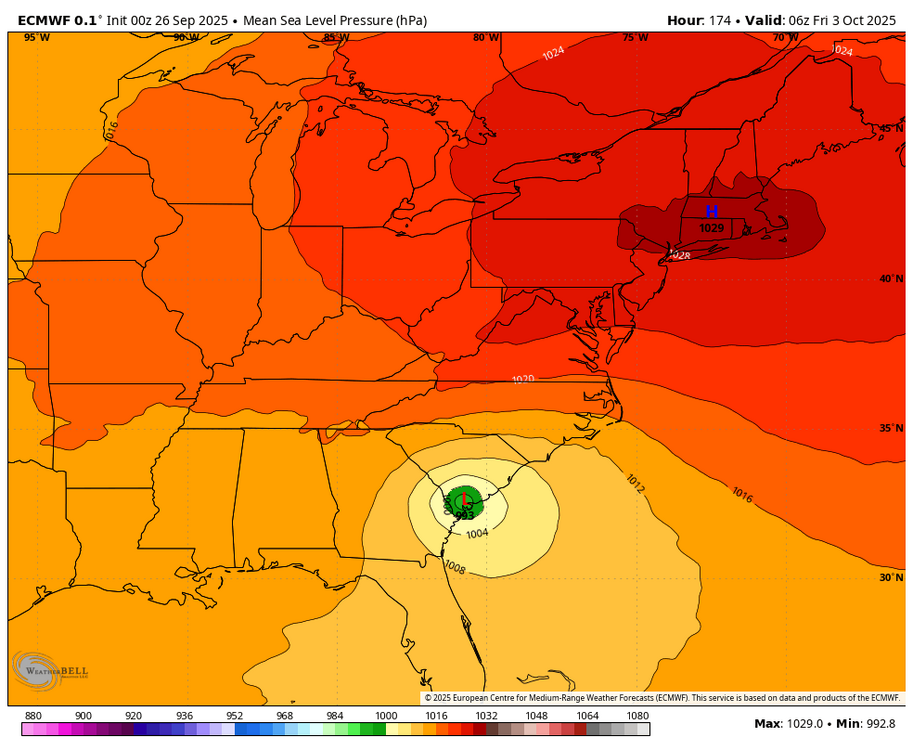
-
Invest 94L—80% 2 day and 90% seven day odds of development
GaWx replied to WxWatcher007's topic in Tropical Headquarters
0Z Euro much different vs prior Euros
-
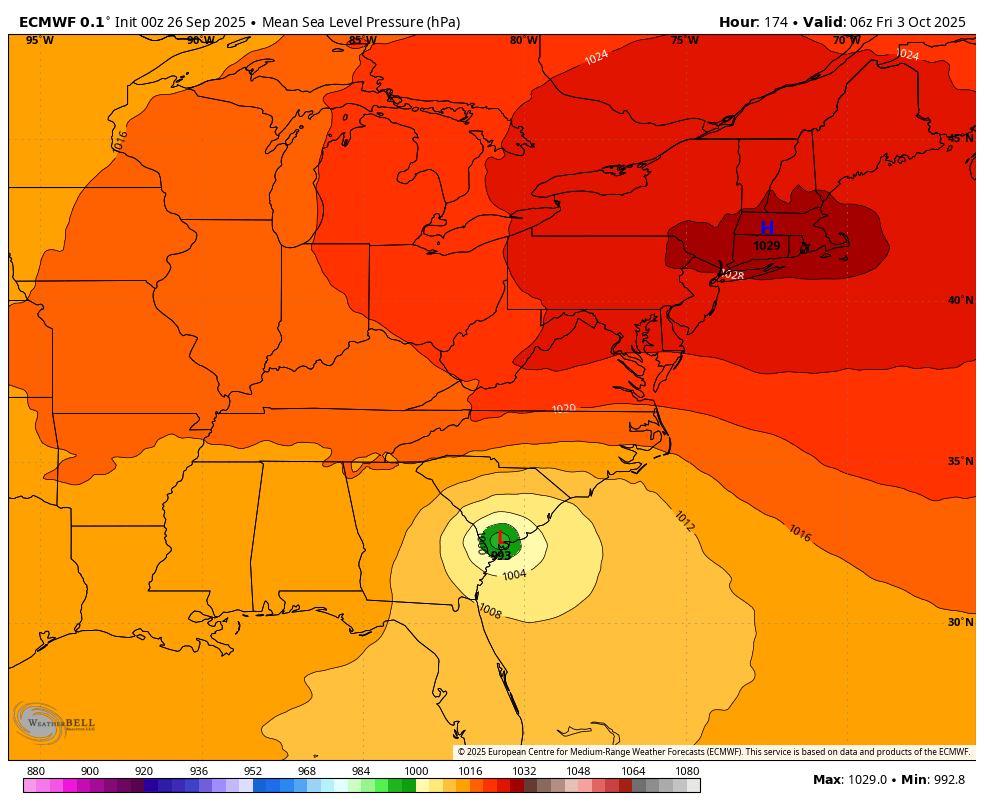
 The only good news should this storm stall over the Carolina’s is the very dry antecedent conditions. This has been one of the driest periods in NC since I was born. We have just 0.16” for the month and going back to mid August we have had well under 1/2” for the entire period. That being said tropical rains can and will cause flooding no matter the antecedent conditions but that certainly helps as almost all rivers and watersheds are low There is a favorable environment for strengthening through the Bahamas and the way the MLC presents itself this morning I believe the storm will likely take advantage of that. How well formed it gets there will likely be key to future intensity because it appears there will be southwesterly shear at some point in approach and likely some dry air intrusion but a mature strong cyclone can be more tolerant of that. If it slows down north of the NC/SC border and sits over the shelf water from Wilmington to hatteras it will likely weaken because shelf temps are unseasonably cool, in the 70s. It goes without saying intensity will be tricky but a stronger storm over the Bahamas and quicker speed into landfall would likely lead to a stronger storm on the coast. Anything that takes its time organizing or moves slowly into coast likely stays relatively weak. ATM since this is only a few days away I would think a cat 1 hurricane is most likely with a cat 2 being the ceiling if it landfalls. This is not a region that favors cat 3 landfalls and it takes almost a perfect setup to get one. Add in all of the cat 3+ storms ti affect the Carolina’s were mature hurricanes that had been strong for quite awhile before approaching. This system is basically home brew (I know it’s from an African wave but it will not develop until the Bahamas). In other words, there is not a climo precedent for a major hurricane landfall in the Carolina’s from a setup like this with a storm forming this close. As others have said, rainfall potential is rather high here, again. Given dry conditions as of present it might temper some impacts but 12”+ amounts would be likely if many model solutions verify and that’s… not good
 -
Talking about that event, or March 2013, should be insta IP ban.
-
Invest 94L—80% 2 day and 90% seven day odds of development
GaWx replied to WxWatcher007's topic in Tropical Headquarters
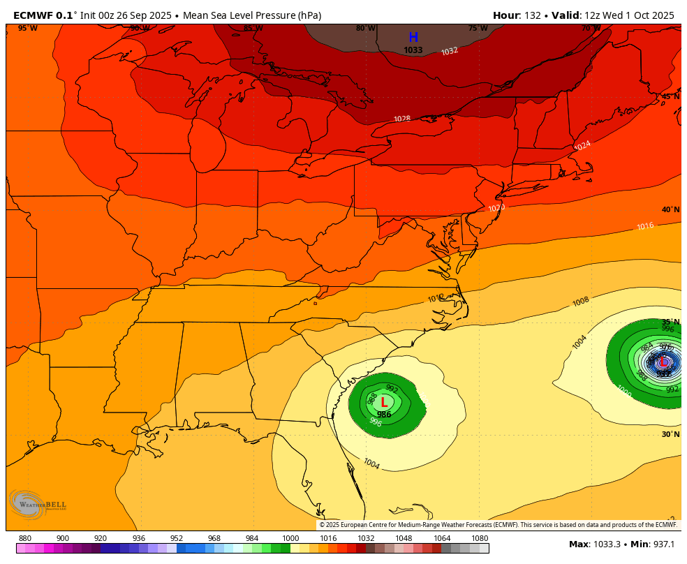
0Z: So far, similar to 12Z with GFS hitting Myrtle Beach while Icon, CMC, and UKMET again all Fujiwara 94L safely OTS JMA only goes out to 72 at 0Z…so, can’t tell much Euro is next —————- 0Z UKMET: NEW TROPICAL CYCLONE FORECAST TO DEVELOP AFTER 48 HOURS FORECAST POSITION AT T+ 48 : 22.5N 76.7W LEAD CENTRAL MAXIMUM WIND VERIFYING TIME TIME POSITION PRESSURE (MB) SPEED (KNOTS) -------------- ---- -------- ------------- ------------- 0000UTC 28.09.2025 48 22.5N 76.7W 1004 39 1200UTC 28.09.2025 60 24.8N 76.1W 1003 41 0000UTC 29.09.2025 72 25.6N 76.6W 1000 42 1200UTC 29.09.2025 84 26.5N 77.1W 999 40 0000UTC 30.09.2025 96 27.3N 77.3W 997 43 1200UTC 30.09.2025 108 27.3N 77.3W 995 43 0000UTC 01.10.2025 120 27.1N 75.4W 992 44 1200UTC 01.10.2025 132 27.3N 73.5W 989 44 0000UTC 02.10.2025 144 28.8N 70.0W 984 52 1200UTC 02.10.2025 156 30.8N 65.1W 979 69 0000UTC 03.10.2025 168 34.6N 57.8W 972 76 -
Biscotti values continuity...unfortunately to a fault, smh I mean yeah I know we were technically winning and we had reached the AFC championship, but...oy. (I kinda feel like that did nothing but buy Harbs more time. Like getting deep in the playoffs that year actually made that decision more difficult, smh I'm starting to wish we hadn't gotten that deep, lol
-
To overperform it has to have an inner core built pretty quickly this weekend. That’s worth watching for sure. The intensification as it’s landfalling is an interesting signal since the environment is not ideal by then.
-
It’s a very interesting setup. Still very unclear what’ll happen.
-

September 2025 OBS-Discussion centered NYC subforum
doncat replied to wdrag's topic in New York City Metro
0.17" here, was expecting more like 1.50".